Garmin
195 productos

| Valoración general | (13 opiniones) |
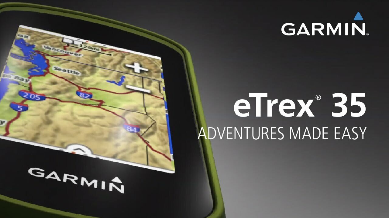
eTrex Touch 35 is the new family navigator for outdoor activities and alpine adventures, ideal for everyone that likes to dip their toes into the great outdoors - from casual cyclists and hikers to geocaching newbies and hillwalkers.
eTrex has been the world’s most popular and successful recreational GPS series for the past 15 years. eTrex Touch 35 is its newest member, that is now easier and more convenient to use than ever. With additional altimeter, it also supports alpine activities like mountaineering and mountain biking. It comes with preinstalled TopoActive Europe maps and optimised Activity Profiles for various recreational activities, not forgetting 250,000 geocaches for endless fun outdoors. With smart notifications straight to your device from your smartphone1, you can stay connected when you’re on the go. To make it even easier to get going, a cycling mount is included in the box. Get out there and have fun with the family. eTrex will guide you every step of the way.
Garmin family navigator that’s easy and fun to use, with touchscreen, altimeter and preloaded TopoActive Europe maps
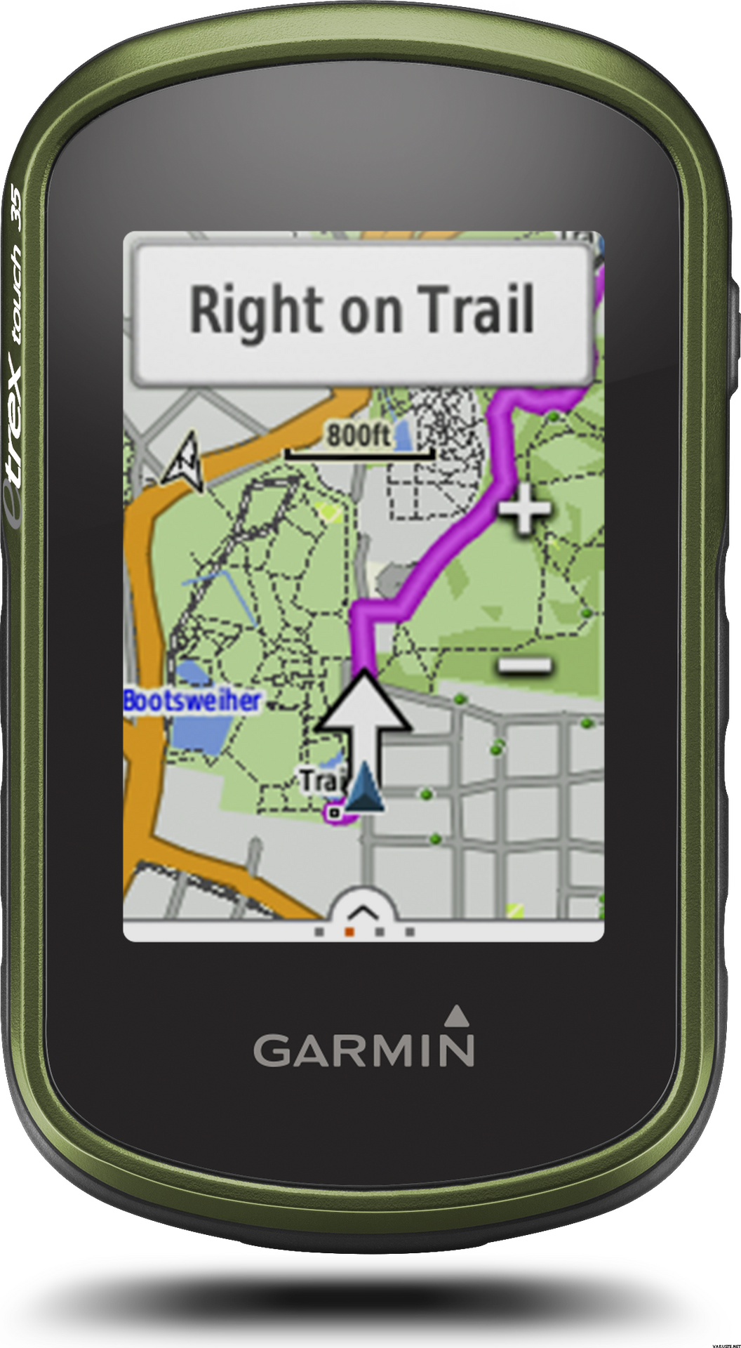
Find your way the easy way
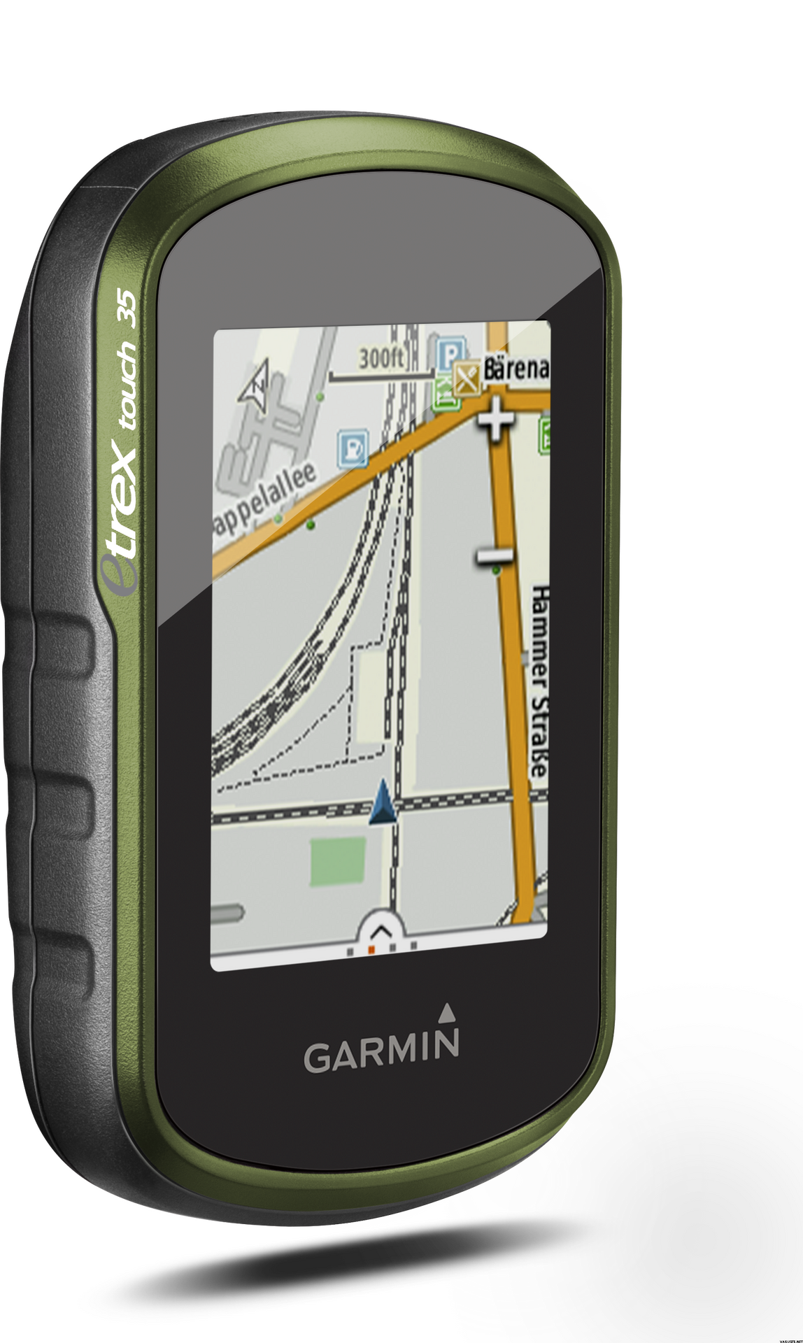
eTrex Touch works like an in-car sat nav, but with maps and features specifically designed for navigation during recreational activities like cycling and hiking. Whether you have a specific destination in mind, or you just want to record your activities to share later on, eTrex Touch gives you the freedom to explore with confidence. You can even find and download activities others have completed on Garmin Connect and Garmin Adventures, or share your own with the community.
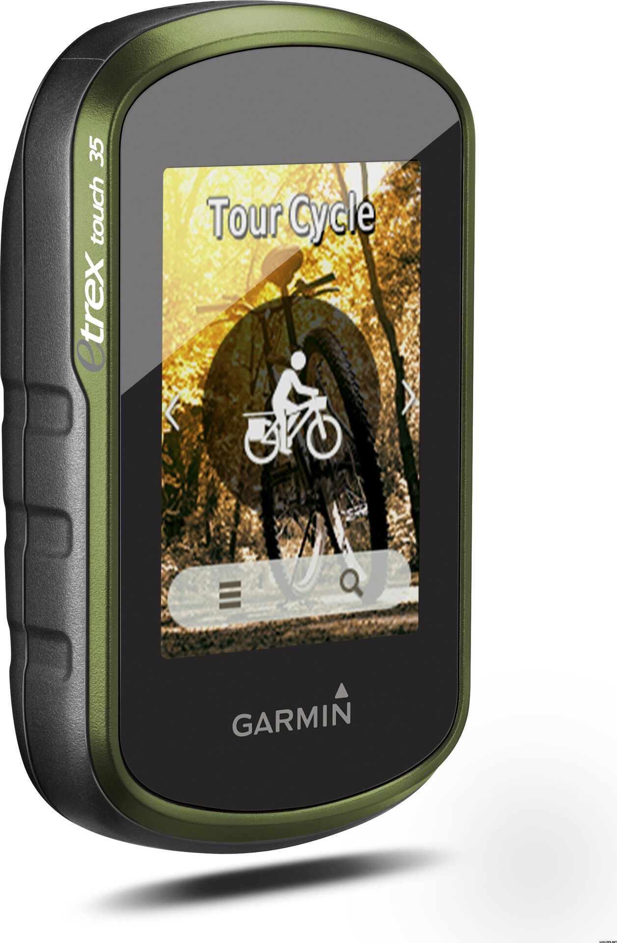
With an easy to use touchscreen, the kids will be able to have a go too. Just touch and go, as the moment takes you! The Activity Profiles give you immediate access to customised profiles like hiking, cycling and geocaching, so you’re all set up for your chosen activity, with everything you need at your fingertips. You can focus on enjoying the great outdoors, and having a great time with your family – knowing you’re in safe hands.
All ready and set to ride
eTrex Touch holds no one back, it’s everything you need to get out there and experience the outdoors at every opportunity. Not only is it designed to enhance whatever activity you fancy that day but it comes fully prepared for you to take it straight out the box and get going.
With a cycling mount included, the eTrex Touch is particularly appealing to recreational cyclists, who can easily fix the device to their handlebars.
The device comes preloaded with Garmin TopoActive Europe maps for 46 countries - just switch the device on, connect to GPS and start navigation. And the maps can be updated at no additional cost. With a large 8 GB internal memory and a microSD slot, there’s plenty of room for additional mapping, whether you’d like to enhance it with advanced topo maps or marine maps.
Dive into geocaching
Experience the great outdoor GPS treasure hunt called geocaching. With the eTrex Touch, geocaching is convenient for everyone, with paperless geocache directions, ratings and recent logs saved directly on the device - no need to print anything.
eTrex Touch 35 comes with an electronic compass that shows you the direction to your destination even while you’re stood still - which helps a lot during short breaks on geocaching adventures.
For beginners, eTrex Touch holds 250,000 great geocaches suitable for those new to geocaching – to help you get used to the whole concept. All geocaches are from geocaching.com, the world’s largest geocaching platform.
Adventures unearthed and shared
Don’t have a specific destination or route in mind? Search for recommended adventures on Garmin Connect or Garmin Adventures, and see routes and geocaches that others have completed. Then download them to eTrex Touch ready for your next adventure. Or create and customise a completely new route to download to your device.
Want to save and re-live a recent adventure? eTrex Touch records where you’ve been so you can upload your routes to Garmin Connect or Garmin Adventures and relive them whenever you want. Garmin Connect and Garmin Adventures are free and allow you to share your recreational adventures with friends and family.
Rock solid eTrex quality
eTrex Touch is the latest product from the famous eTrex GPS handheld series. These products have been successfully deployed all over the earth, from the freezing poles to the heat of African deserts and the humid South American jungles. eTrex has mastered all terrains and the eTrex Touch offers that same toughness and endurance.
eTrex Touch supports GPS and GLONASS, giving you the power of two satellite systems, for faster fix and better accuracy in challenging environments. Let eTrex do all the hard work for you – just check your actual position and follow the guidance. eTrex 35 also adds a barometric altimeter to the mix, for safer navigation in alpine environments and accurate elevation data.
The device is fully ruggedised, IPX7 water-rated and has a scratch-resistant screen. The long 16 hour battery life and field-replaceable standard AA batteries guarantee flexibility when you’re on the go.
eTrex Touch also provides all of the classic eTrex features like hunting and fishing information, sport watch, sun and moon calendar, sunrise and sunset data and much more.
Compact and versatile companion
The handy device fits easily into a pocket or on a handlebar. It’s also designed to be a size that allows kids to easily handle it too. Using the spine mount mounting system, eTrex Touch can be mounted pretty much anywhere with specialised mounts for boats, cars, backpacks etc.
Stay connected
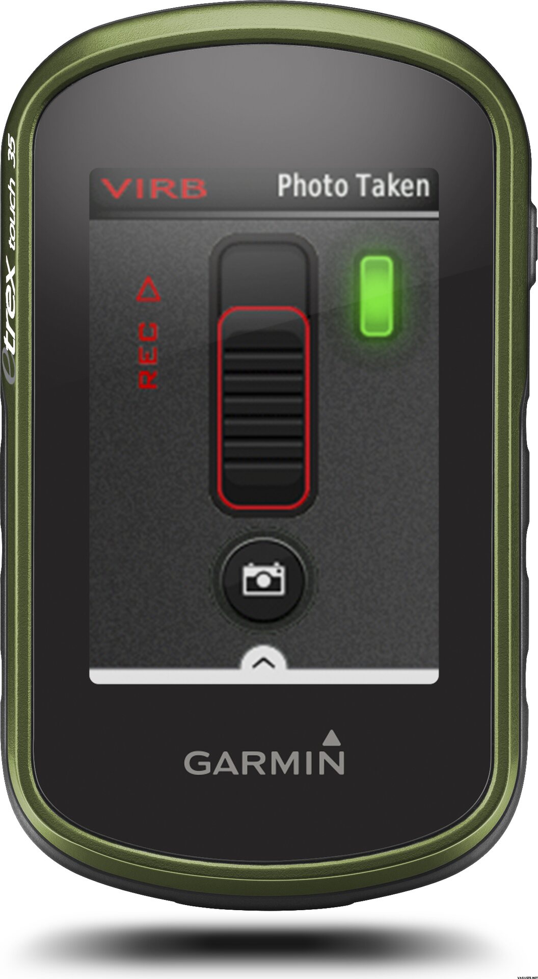
eTrex Touch 35 lets you share your waypoints, tracks, routes and geocaches wirelessly, through unit-to-unit sharing with compatible Garmin devices. With the smart notification feature, you’ll never miss a text, email or notification from your compatible smartphone*, unless you want to. You can also use your eTrex Touch 35 as a remote control for our VIRB® XE, VIRB X and VIRB Elite action cameras.
eTrex Touch 35 also supports Live Track which allows your friends and family to follow your activities in real time. Invite followers, via email or social media, to track your activity and location on Garmin Connect.
Physical & Performance
Physical dimensions5.8 x 10.2 x 3.3 cm
Display size, WxH3.6 x 5.5 cm
Display resolution, WxH160 x 240 pixels
Display type2.6" 65K colour TFT
Touchscreen
Weight159 g with batteries
Battery2 AA batteries (not included); NiMH or Lithium recommended
Battery lifeUp to 16 hours
Water ratingIPX7
High-sensitivity receiver
InterfaceUSB
Camera
No
Barometric altimeter
Electronic compass
Unit-to-unit transfer (shares data wirelessly with similar units)
Maps & Memory
Basemap
Preloaded maps
No
Ability to add maps
Built-in memory8 GB
Accepts data cardsmicroSD™ card (not included)
Custom POIs (ability to add additional points of interest)
Waypoints/favorites/locations4000
Routes200
Track log10,000 points, 200 saved tracks
Outdoor Features
Automatic routing (turn by turn routing on roads)Yes (with optional mapping for detailed roads)
Geocaching-friendlyYes (Paperless)
Custom maps compatible
Sun and moon information
Tide tablesYes (with optional Bluechart)
Area calculation
Picture viewer
Garmin Connect™
Garmin Connect™ compatible (online community where you analyze, categorize and share data)
Additional
Additional
Smart Notifications: Yes
Live Tracking: Yes (with Garmin Connect™ Mobile)
 Taiwan
 — Mostrar original
 — Mostrar original
Es bueno que la aplicación esté lista en la tarjeta de memoria. Si es necesario, también se puede descargar del sitio web del National Land Survey of Finland. El Garmin eTrex tiene un tamaño conveniente. El tamaño importa, los grandes no siempre quieren ni siquiera llevárselo. El dispositivo no venía con un manual de usuario en finlandés. Puede encontrarlo en línea y también puede imprimir desde allí. El dispositivo comprado en Finlandia supondría que el manual está incluido, preferiblemente todavía en color. Las baterías recargables duran más. Vale la pena comprarlos, no incluidos en la entrega, que ya se conoce al realizar el pedido.| Valoración general |
— Mostrar originalDispositivo bueno y preciso. Menús bastante complejos, por lo que aún no he aprendido todas las funciones.| Valoración general |
— Mostrar originalCompré el dispositivo principalmente para geocaching y, en segundo lugar, para ciclismo. Estaba buscando un dispositivo de pantalla táctil pequeño con buena duración de batería y este fue seleccionado. Me tomó un tiempo acostumbrarse a la lógica de navegación del menú, pero comenzó a encontrar las funciones y configuraciones necesarias. Dispositivo pequeño, pero lo suficientemente claro en la pantalla y el mapa. Personalmente, me cuesta un poco descargar cachés a mi dispositivo (uno a la vez desde un navegador de computadora a un dispositivo). Probablemente hubiera sido más útil con la consulta Pocket de Geocaching si hubiera una membresía premium. Luego, ingresará con más frecuencia las coordenadas de la caché en Garmin y examinará las descripciones de la caché en su teléfono. En el ciclismo, se suponía que Garmin reemplazaría el teléfono con navegación y llevaría fuentes de alimentación de repuesto. El portabicicletas incluido está bien, aunque hay un accesorio de brida para cables. Las funciones de navegación, al menos en un enlace de ciudad, no son las mejores que pueden ser. Antes de adquirir Garmin, me gustaba planificar un viaje en bicicleta a nuevas áreas con Google Maps y transferirlo a mi teléfono. No es muy fácil, al menos a primera vista, planificar una ruta en el software Base Camp de Garmin (en una computadora) o, cuando se ingresa directamente en el dispositivo. Quizás debido a esto, luego tuve que hacer más en la navegación del teléfono como asistente de los bucles de bicicleta, incluso con un poco de esfuerzo y aprendizaje, incluso llevando a Garmin a un nivel tolerable.| Valoración general |
— Mostrar originalHa funcionado bien. Sin embargo, una vez que parecía que la distancia que estaba viajando, ya fuera debido a las heladas severas, había energía en los radiadores.| Valoración general |
— Mostrar originalBien, geps básicos. La pantalla no es muy extraña en comparación con un teléfono celular, pero brinda certeza y seguridad para navegar en viajes más largos.| Valoración general |
— Mostrar originalDispositivo de tamaño conveniente y fácil de usar después de un poco de práctica. Unirlo al relleno es una buena adición y ayuda cuando se recorre la ruta en bicicleta.
Diseñado principalmente para su uso en Geocaching. La entrega fue rápida y la empresa ya estaba familiarizada, todo funciona bien.| Valoración general |
— Mostrar originalUn artilugio útil. Inicialmente, lo conseguí para geocaching, pero parece estar posicionado en el manillar de la bici para dar información y mostrar el mapa ... habrá más pólvora en los muslos para lucir :) En geocaching, la pantalla parecía de alguna manera demasiado pequeño, pero tal vez te acostumbres también. Sorprendentemente, al andar en bicicleta, la información es visible y el mapa es fácil de leer.
Sí, se necesitan muchas baterías, así que de inmediato obtuve baterías recargables y un cargador. Buen artilugio!| Valoración general |
— Mostrar originalUn navegador deportivo verdaderamente versátil. Lo uso principalmente para ciclismo de montaña, pero también funciona para senderismo y esquí.| Valoración general |
— Mostrar originalBien, pero requiere tiempo de entrenamiento para esos ricos perfiles y menús.