
Garmin
194 products

| Overall rating | (3 reviews) |
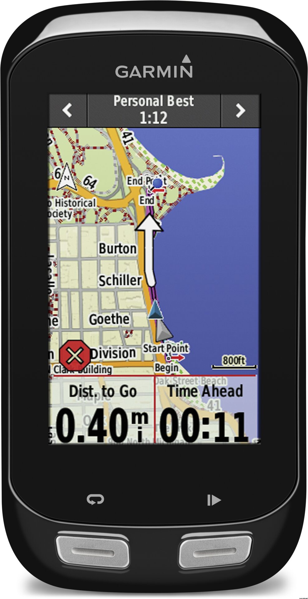
Along with in-ride challenges and connected features, Edge 1000 offers advanced bike-specific navigation and mapping capabilities. The preloaded Garmin Cycle Map includes OSM (Open Street Map) content with routable road and bike paths, elevation data, points of interest and address search. Mapping data is stored onboard the Edge, so your access to navigation and performance capabilities isn’t dependent on cell coverage, and map updates are free.
Now you can explore more, on and off road, thanks to this device’s round-trip routing feature. Simply enter how far you want to ride, and Edge 1000 calculates up to 3 cycling-friendly routes. You can even review the elevation profiles before making your selection. It also offers a new route planner capability that allows you to create routes directly on the Edge 1000 using the map, POI and segments you’ve downloaded from Garmin Connect. Again, you can preview the elevation profile of your custom route before you roll. If you do get off course or want to end your ride sooner, Edge can always guide you back to start or calculate the most direct route and provide turn-by-turn directions to get you back.
Edge 1000 features a 3-inch high-resolution color touchscreen display with dual orientation. It has an ambient light sensor that automatically adjusts the screen brightness to changing light conditions to improve visibility. Unlike your smartphone, the display is optimized to work with gloves and in the rain³. You can customize your training pages with up to 10 data fields and use activity profiles to allow for easy transitions when you switch cycling activity, such as road, mountain or touring.
Edge 1000 is compatible with ANT+® sensors, including speed, cadence, heart rate and compatible weight scale. It’s the first Garmin bike computer that integrates with Shimano Di2 electronic shifting systems4 to display your current gear on the screen. Edge 1000 is also compatible with ANT+ power meters, including Vector™, our unique pedal-based power meter that measures total power, left/right balance and cadence. A preloaded power-based workout on Edge 1000 allows you to calculate your functional threshold power (FTP), from which you can base your power training zones. The 1000 offers a training calendar and is compatible with advanced workouts, which you can plan, schedule and upload from Garmin Connect.
When paired with a dual-sensing Vector power meter, Edge 1000 displays our revolutionary Cycling Dynamics metrics and are included in Garmin Connect for post ride analysis. These metrics measure where the power is being applied throughout the pedal stroke, and where on the pedal it is being applied, allowing the cyclist to understand his or her particular way of riding.
Compatible Garmin Edge devices will now work with WKO4 individual power levels (iLevels), the newest metric for cyclists and triathletes who train with a power meter. Developed by Dr. Andrew Coggan, iLevels are specific training levels based on an athlete’s unique physiology and current level of fitness.
WKO4 software, developed by TrainingPeaks, has changed how coaches and athletes analyze data and prescribe workouts. Fully customizable charts allow you to view and compare specific data to gain clearer insights into your training. Based on the introduction of the power duration curve, WKO4 has introduced several new training metrics, including Functional Reserve Capacity and Pmax tracking, which help coaches and athletes track their specific fitness.
The prescription of power-based training is derived from an athlete's Functional Threshold Power and targeted to general percentages. iLevels are based on the power duration curve and adjust automatically based on your performance. They detect micro changes in fitness to ensure you are always training at the right intensity.
Now you can update iLevels directly from WKO4 by simply plugging in your Edge 1000 and automatically downloading the daily iLevels to your Garmin device. These iLevels will be displayed in a unique 9 levels view on the Garmin head unit and will be available in workouts. Download a free 14-day trial of WKO4.
When paired with your smartphone and the Garmin Connect™ Mobile app, Edge 1000 offers a suite of connected features, including live tracking, incoming call and text alerts, social media sharing, weather, wireless uploads and sending/receiving courses and segments. As soon as your ride is complete, the data can be automatically sent to Garmin Connect via Bluetooth® or Wi-Fi®. This lets you stay connected and instantly share the details of your ride with friends, family and social media contacts. LiveTrack allows your friends and family to follow your races and training activities in real time. Invite followers using email or social media, so they can view your live data on a Garmin Connect tracking page. Once they get your email invite, they can click to follow and see your stats and location on the map.
LiveTrack lets family and friends track your location in real-time while you’re riding, and now it’s even easier to use. When you enable auto-start, you can spend more time focusing on the ride and less on the technology. LiveTrack will automatically detect when you start riding, which means there’s no need to even reach for your phone anymore. Auto-start is also compatible with the new Strava Beacon, which lets Strava Premium subscribers take advantage of the same great feature. It’s never been easier for you and your loved ones to have peace of mind while you ride.
| Overall rating | ☆☆☆☆☆ |
 — Show original
| Overall rating |
— Show originalGarmini got into a real test drive with Team Rynkeby Helsinki 1221 km from the Paavo statue to Paris. There was heat, wind and rain that is not encountered in Finland! With Garmin, the route was navigated just fine. The display is accurate in all weather conditions. The pointless rain caused some operational problems, as the monitor practically swam in the water and did not accurately respond to commands. The screen is also large enough for an older user. The only downside is actually the poor visibility of the arrow showing your location on the map. With the most accurate navigation possible, ie both satellite options in use, the battery was not enough for a full 10h driving day. However, when charging from the battery, the device was quickly ready for use. The maps in Europe were accurate and functional, the terrain maps of Finland have not been tested. The menu structure requires learning, but is reasonably clear. Customizable displays serve a wide variety of uses. I recommend! — Show originalBoth the device and the National Land Survey map seem to work as they should during a short test period. Good. — Show originalProbably be on all devices (phones sun other) max battery life mentioned in the least power consuming settings. I bought itekkin that device quite happy, features whip and more can be charged. Battery life is not yet oo experience. (Know at least save power if the loops stretch longer)