Sports‪» Outdoor activities‪» Electronics‪» GPS‪» Accessories‪» Electronic maps‪»

National Land Survey Of Finland: Electronic Map of Finland in microSD

National Land Survey Of Finland: Electronic Map of Finland in microSD


Price
25,00 + delivery costs
Incl. VAT 25.5 %


Quantity
pc


Available in stock
Store (Helsinki)on-shelfover 30 pcs immediately
Store (Helsinki)in stockover 30 pcs immediately
Available in the webstoreover 30 pcs immediately

Availability
Immediately

Detailed availability

Location Store (Helsinki): checkout, Kassa, warehouse


Reviews
Overall rating ()


Product description
Translated by GoogleShow original

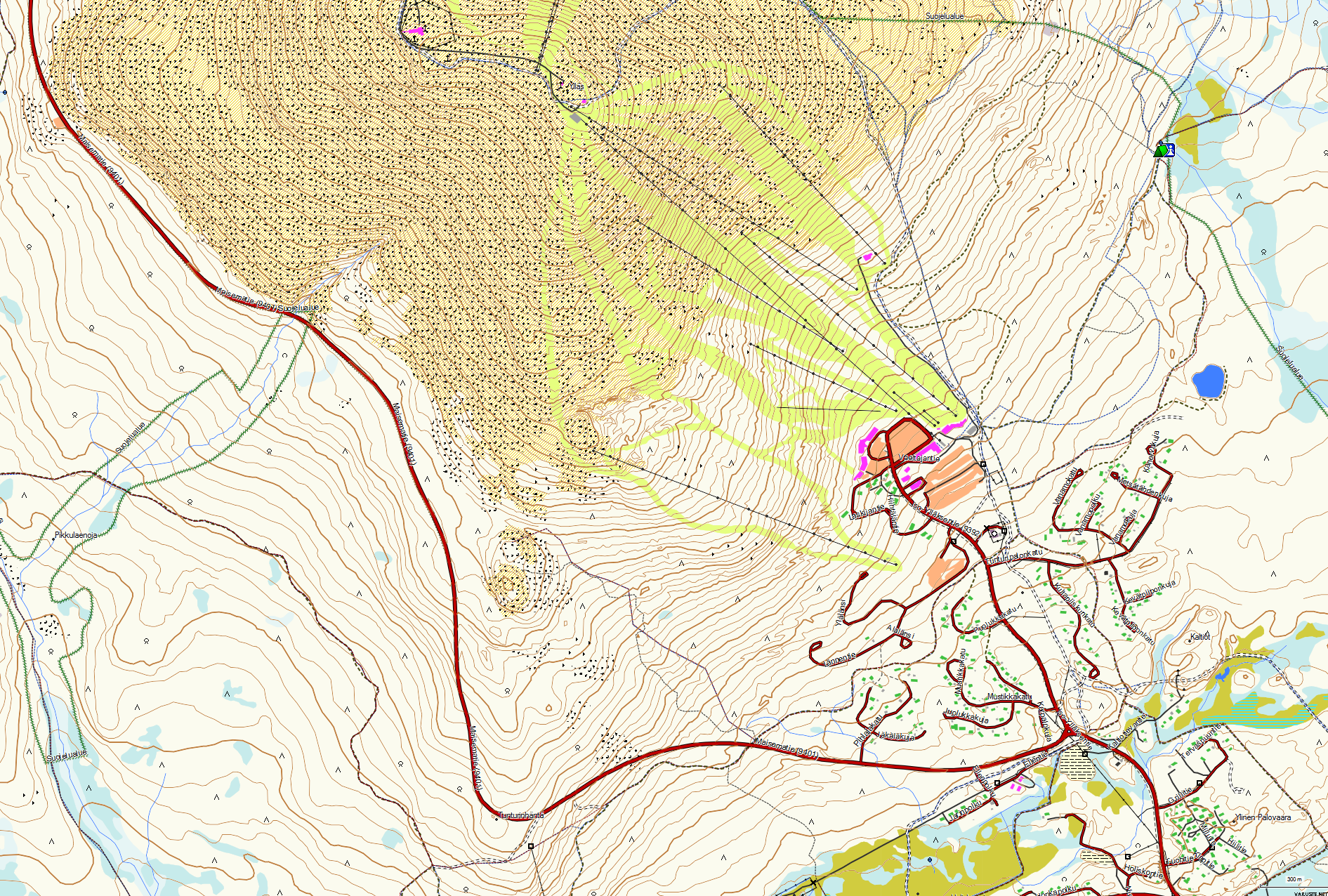
A microSD card suitable for Garmin GPS devices with a memory card slot, which is preloaded with a Terrain map prepared based on the map data of the National Land Survey (Author is Teemu Peltonen. Licensed under a Creative Commons Attribution-Non-Commercial 4.0 Unmodified license.)
An up-to-date version of the map can always be downloaded for free from https://kartat.hylly.org/

  • The MicroSD card contains preloaded terrain maps with the same level and appearance as the basic map of the Land Surveying Institute for Garmin GPS devices
  • The map includes property boundaries
  • The map does not include the boundaries of Metsähallitus' hunting areas
  • There is no routing on the map
  • The use of the map is voluntary
    • Garmin or Viranomainen.fi do not provide user support for installing or using the map
    • Neither Garmin nor Viranomainen.fi takes responsibility for the use of the map
    • You can buy the user manual or user support at https://kartat.hylly.org/


Licenses for using the map:

  • The map contains material from the Land Surveying Institute's Terrain Database. ( License )
  • The map contains material from the Finnish Transport Agency's marine chart database. License for Traficom's marine mapping data
  • The map contains data from Metsähallitus.
  • Data brought to the map from OpenStreetMap © OpenStreetMap contributors. License

Use the electronic map only as a navigation aid

Electronic maps are a navigation aid when using official paper maps. The purpose of electronic maps is not to replace official paper maps. Only official charts and information for mariners publications contain the necessary information for safe navigation. As always, the ship's captain is responsible for navigation methods.

ATTENTION: Information about sea and land areas is always changing, therefore the information on the electronic map does not always include all the latest changes.


The approximate size of the packed product or the sales package is 50 x 50 x 20 mm.


Weight
0,01 kg(Includes the weight of the packaging)


Comments
Pasi M. verified buyer, 26.11.2024
Overall rating
Translated by GoogleShow original
Good accurate maps. It makes camping even more enjoyable when you can see where you are moving.
Anonymous verified buyer, 17.11.2024
Overall rating
Translated by GoogleShow original
Easy deployment
Anonymous verified buyer, 15.11.2024
Overall rating
Translated by GoogleShow original
It worked well on the garmin alpha 300i device.
Anonymous verified buyer, 12.10.2024
Overall rating
Translated by GoogleShow original
Definitely worth getting.
Kari K. verified buyer, 11.10.2024
Overall rating
Translated by GoogleShow original
Works
Anonymous verified buyer, 27.9.2024
Overall rating
Translated by GoogleShow original
Good
Heli K. verified buyer, 14.9.2024
Overall rating
Translated by GoogleShow original
Good accurate map.
Jyrki A. verified buyer, 15.8.2024
Overall rating
Translated by GoogleShow original
Accurate and clear maps
Anonymous verified buyer, 14.8.2024
Overall rating
Translated by GoogleShow original
Accurate maps.
Jari K. verified buyer, 3.7.2024
Overall rating
Translated by GoogleShow original
I haven't been able to get it set up on the Garmin yet.
Show all (16) Add a comment

Products that have often been purchased with this product:

Garmin GPSMAP 67
 
Sports‪»Outdoor activities‪»Electronics‪»GPS‪»Hiking GPS‪»
Garmin GPSMAP 67
499,00 €
(3)
Available in stock
Garmin GPSMAP 65 ja TopoActive Europe -kartat (Länsi-Euroopan pakkaus)
 
Sports‪»Outdoor activities‪»Electronics‪»GPS‪»Hiking GPS‪»
Garmin GPSMAP 65 ja TopoActive Europe -kartat (Länsi-Euroopan pakkaus)
359,00 €
(8)
Garmin GPSMAP 67i
 
Sports‪»Outdoor activities‪»Electronics‪»GPS‪»Hiking GPS‪»
Garmin GPSMAP 67i
599,00 €
(10)
Available in stock
Garmin Montana 700i
 
Sports‪»Outdoor activities‪»Electronics‪»GPS‪»Hiking GPS‪»
Garmin Montana 700i
679,00 €
(5)
Available in stock
-2%
Garmin Montana 700
 
Sports‪»Outdoor activities‪»Electronics‪»GPS‪»Hiking GPS‪»
Garmin Montana 700
Campaign price 636,30 €
(1)
Available in stock
Garmin GPSMAP 65s ja TopoActive Europe -kartat (Länsi-Euroopan pakkaus)
 
Sports‪»Outdoor activities‪»Electronics‪»GPS‪»Hiking GPS‪»
Garmin GPSMAP 65s ja TopoActive Europe -kartat (Länsi-Euroopan pakkaus)
398,90 €
(4)
Available in stock
Garmin eTrex 22x
 
Sports‪»Outdoor activities‪»Electronics‪»GPS‪»Hiking GPS‪»
Garmin eTrex 22x
198,00 €
(16)
Available in stock
Garmin eTrex 32x and TopoActive Europe
 
Sports‪»Outdoor activities‪»Electronics‪»GPS‪»Hiking GPS‪»
Garmin eTrex 32x and TopoActive Europe
249,00 €
(58)
Available in stock
Garmin Montana 750i
 
Sports‪»Outdoor activities‪»Electronics‪»GPS‪»Hiking GPS‪»
Garmin Montana 750i
749,00 €
(2)
Available in stock
-11%
Garmin Alpha 50 Handheld
 
Sports‪»Outdoor activities‪»Electronics‪»GPS‪»GPS Dog Tracking Devices‪»
Garmin Alpha 50 Handheld
Campaign price 439,00 €
(4)
Available in stock


Blog

Hanki esiladattu kartta-aineisto mukaan muistikorttipaikkaisiin Garmin-laitteisiin

Myymme muistikorttipaikkaisiin Garmin GPS-laitteisiin microSD-korttia, johon on esiladattu Maanmittauslaitoksen kartta-aineiston pohjalta laadittu maastokartta (Tekijä on Teemu Peltonen. Lisensoitu Creative Commons Nimeä-Ei muutoksia-Epäkaupallinen 4.0 Muokkaamaton -lisenssillä.)...