Garmin
194 件商品

| 一般评价 | (11 评价) |
The wireless connectivity to Geocaching.com on your Oregon makes it easier than ever to enjoy a superior geocaching experience. You can set your device to automatically stay up to date with all the latest caches. No more manual entry of coordinates or printing out cache details on paper.
The expanded wireless capabilities of Oregon 700 make it easier than ever to update software, check the weather radar2 and upload adventures to ourGarmin Connect online community. You can even share LiveTrack location data or geocache discoveries via WiFi or smartphone. Smart Notifications via Bluetooth connectivity with a compatible smartphone let you receive emails, texts and alerts right on your device. So you can see what’s going on while you’re getting away from it all.
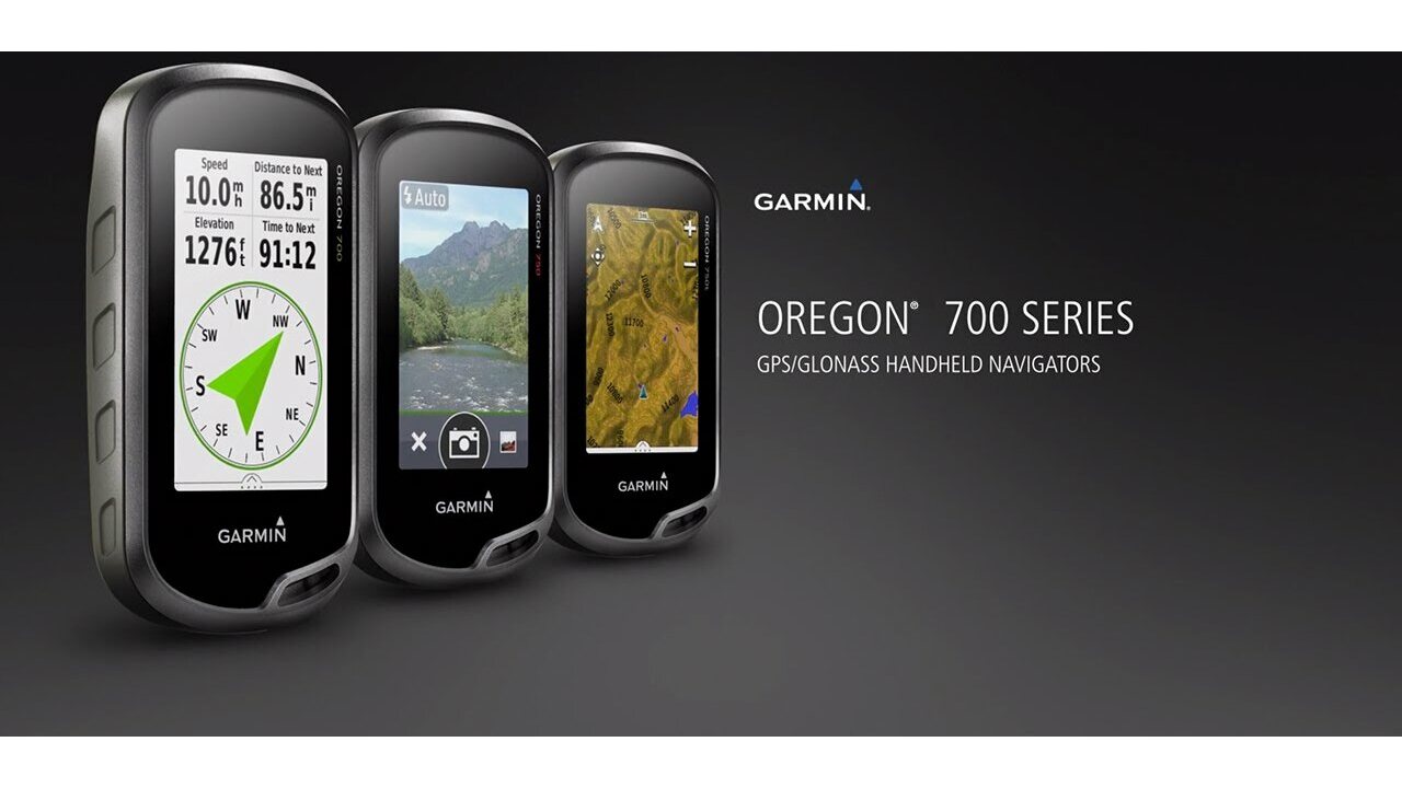
The Oregon 700 handheld provides comprehensive navigation and tracking to guide you on and off the beaten path, using GPS and GLONASS plus ABC (altimeter, barometer and compass) sensor capabilities. The built-in altimeter provides elevation data to accurately monitor ascent and descent, while the barometer can be used to predict weather changes by showing short-term trends in air pressure. The 3-axis electronic compass keeps your bearing, whether you’re moving or not. There’s also a TracBack® feature on Oregon 700 to help you navigate back to your starting point the same way you came. You can also mark locations, such as your campsite, vehicle or other points of interest, to which you'd like return navigation.
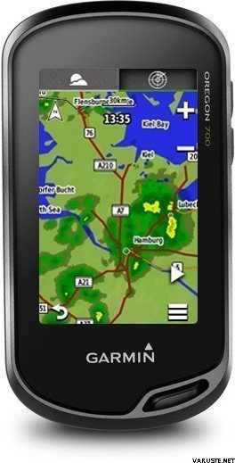
The Oregon 700 handheld features a bright, sunlight-readable 3-inch colour touchscreen display with dual orientation for landscape or portrait views. It easily supports multiple mapping options such asBlueChart® g2 HD for water navigation or City Navigator® for turn-by-turn driving directions. Durable and water-rated to IPX7, the Oregon series is built to keep delivering vital mapping and tracking data, no matter what the elements throw at you. Plus, you can even customise your Oregon’s display with free downloads from the Garmin Connect IQ™ online store3.
Take charge of your next adventure with BaseCamp™, software that lets you view and organise maps, waypoints, routes and tracks. This free trip-planning software even allows you to create Garmin Adventuresthat you can share with friends, family or fellow explorers online. BaseCamp displays on your computer screen any topographic map data stored on the device, including contour lines and elevation profiles. It also can transfer an almost unlimited amount of satellite images to your device using the included BirdsEye Satellite Imagery subscription.
1When paired with a compatible smartphone. See garmin.com/ble for compatibility.
2Active Weather is available in the UK, Ireland, Portugal, Spain, France, Germany, Belgium, Netherlands, Luxembourg, Switzerland, Denmark, Norway, Sweden, Finland, Austria and Slovenia with partial coverage in Northern Italy.
3Apps, widgets and data fields will be introduced when they become available; not all products may be available all the time. Please check ourwebsite for current inventory of Connect IQ products.
The Bluetooth® word mark and logos are registered trademarks owned by Bluetooth SIG, Inc. Wi-Fi® is a registered trademark of the Wi-Fi Alliance.
Physical & Performance |
|
| Physical dimensions | 6.1 x 11.4 x 3.3 cm |
|---|---|
| Display size, WxH | 3.8 x 6.3 cm; 3" diag (7.6 cm) |
| Display resolution, WxH | 240 x 400 pixels |
| Display type | Transflective colour TFT touchscreen |
| Touchscreen | |
| Weight |
209.8 g with batteries |
| Battery | 2 AA batteries (not included); NiMH or Lithium recommended, rechargeable NiMH pack (optional) |
| Battery life | Up to 16 hours |
| Water rating | IPX7 |
| High-sensitivity receiver | |
| Interface | high-speed USB and NMEA 0183 compatible |
| Camera |
No |
| Barometric altimeter | |
| Electronic compass | Yes (tilt-compensated 3-axis) |
| Unit-to-unit transfer (shares data wirelessly with similar units) | Yes (plus images and custom maps) |
Maps & Memory |
|
| Basemap | |
|---|---|
| Preloaded maps |
No |
| Ability to add maps | |
| Built-in memory | 1.7 GB |
| Accepts data cards | microSD™ card up to 32 GB (not included) |
| Custom POIs (ability to add additional points of interest) | |
| Waypoints/favorites/locations | 10,000 |
| Routes | 250 |
| Track log | 20,000 points, 250 saved tracks |
Outdoor Features |
|
| Automatic routing (turn by turn routing on roads) | Yes (with optional mapping for detailed roads) |
|---|---|
| Geocaching-friendly | Yes (Paperless) |
| Custom maps compatible | |
| Hunt/fish calendar | |
| Sun and moon information | |
| Tide tables | |
| Area calculation | |
| Picture viewer | |
Garmin Connect™ |
|
| Garmin Connect™ compatible (online community where you analyze, categorize and share data) | |
|---|---|
Additional |
|
| Additional |
|
|---|---|
 Taiwan
| 一般评价 | ☆☆☆☆☆ |
 — 显示原文
| 一般评价 |
— 显示原文
这是我拥有的第三个俄勒冈州。我主要用它来骑自行车。我得到了第三个,所以我不必为我的车把购买新的固定装置并学习新的系统。我希望它的使用寿命比我的 Oregon 600 长得多。几年后,当在法国阳光下骑行一周时,两个按钮上的橡胶完全降解,结果失败了。
700比600唱歌跳舞多了。续航好像少了一些。它需要 AA 电池,我现在随身携带备用电池。
尽管有这些负面因素,我仍然喜欢俄勒冈州。我发现它很容易使用,而且我喜欢它的屏幕尺寸。| 一般评价 |
— 显示原文
这是最好的 Garmin GPS,他们不再生产了。现在的型号差很多,因为GPSMAP66在高程测量上有严重的误差,按钮很笨拙,蒙大拿是一块砖头,不适合徒步旅行。| 一般评价 |
— 显示原文一个好的手握。这已经是他们第三次不能保级了。
最好的是屏幕,阳光越多,屏幕越亮。| 一般评价 |
— 显示原文价格质量比似乎是正确的。与我之前带按钮的导航器相比,易于使用。随附的地形图效果很好。| 一般评价 |
— 显示原文长途旅行的电池寿命不佳,屏幕在阳光下完全无法使用。顺便说一句,尺寸相对较小。不幸的是,Garmin 似乎没有任何竞争对手,所以我们就这样吧。
土地测量院的地图是必要的补充!| 一般评价 |
— 显示原文xTrex 20 之前的用户体验是积极的,相比之下有很多改进,地形图是至高无上的荣耀
事物。