
Garmin
195 件商品


| 一般评价 | (70 评价) |
Rugged, Full-featured Handheld with GPS, GLONASS and Wireless Connectivity
2.6" sunlight-readable color screen
High-sensitivity GPS and GLONASS receiver with quad helix antenna
1-year BirdsEye Satellite Imagery subscription
3-axis compass with barometric altimeter
Wireless connectivity via Bluetooth® technology¹ or ANT+™
GPSMAP 64s
GPSMAP 64s features a 2.6” sunlight-readable color screen and a high-sensitivity GPS and GLONASS receiver with a quad helix antenna for superior reception. GPSMAP 64s includes a 3-axis electronic compass with barometric altimeter, wireless connectivity and a 1-year BirdsEye Satellite Imagery subscription.
Get Your Bearings
GPSMAP 64s has a built-in 3-axis tilt-compensated electronic compass, which shows your heading even when you’re standing still, without holding it level. Its barometric altimeter tracks changes in pressure to pinpoint your precise altitude, and you can even use it to plot barometric pressure over time, which can help you keep an eye on changing weather conditions.
Share Wirelessly
Share your waypoints, tracks, routes and geocaches wirelessly with other compatible devices. Your friends can enjoy your favorite hike or cache without waiting for you to plug in to your computer — simply press “send” to transfer your information to another Garmin handheld.
GPSMAP 64st also connects to compatible Garmin devices, including VIRB™ and accessory sensors, including tempe™, foot pod and heart rate monitor.
Stay Connected
With Smart Notification you can wirelessly receive email, texts and alerts from your compatible iPhone® 4s or later. Stay connected without having to dig into your backpack for your smartphone.
Explore the Terrain
GPSMAP 64s comes with a built-in worldwide basemap with shaded relief plus a 1-year BirdsEye Satellite Imagery subscription, so you can navigate anywhere with ease. With photo navigation, you can download geotagged pictures from the Internet and navigate to them.
Keep Your Fix
With its quad helix antenna and high-sensitivity, GPS and GLONASS, receiver, GPSMAP 64s locates your position quickly and precisely and maintains its location even in heavy cover and deep canyons. The advantage is clear — whether you’re in deep woods or just near tall buildings and trees, you can count on GPSMAP 64s to help you find your way when you need it the most.
Add Maps
GPSMAP 64s comes with a built-in worldwide basemap with shaded relief and a 1-year subscription of BirdsEye Satellite Imagery for a photo-realistic view. Adding more maps is easy with our array of detailed topographic, marine and road maps. With 4 GB of onboard memory and microSD™ card slot, you can conveniently download TOPO 24K and 100K maps and hit the trail, plug in BlueChart® g2 preloaded cards for a great day on the water or City Navigator NT® map data for turn-by-turn routing on roads (see maps tab for compatibility). In addition, the 64s is compatible with Garmin Custom Maps, a map format that allows you to transform paper and electronic maps easily into downloadable maps for your device, for free.
Find Fun
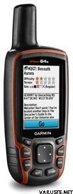
GPSMAP 64s supports paperless geocaching with 250,000 preloaded caches with hints and descriptions from Geocaching.com, and has a 16-hour battery life. By going paperless, you're not only helping the environment, but also improving efficiency. GPSMAP 64s stores and displays key information, including location, terrain, difficulty, hints and descriptions, which means there’s no more manually entering coordinates and paper printouts! Slim and lightweight, 64s is the perfect companion for all your outdoor pursuits.
Plan Your Next Trip
Take charge of your next adventure with BaseCamp™, software that lets you view and organize maps, waypoints, routes and tracks. This free trip-planning software even allows you to create Garmin Adventures that you can share with friends, family or fellow explorers. BaseCamp displays topographic map data in 2-D or 3-D on your computer screen, including contour lines and elevation profiles. It also can transfer an unlimited amount of satellite images to your device when paired with a BirdsEye Satellite Imagery subscription.
 Taiwan
| 一般评价 | ☆☆☆☆☆ |
 — 显示原文
 — 显示原文
作为第一台 GPS 设备,很难在手册中找到初学者需要的准确说明。包装上完全没有芬兰语说明,在网上找到它们需要互联网连接和技能,如果没有年轻人的帮助,70 岁以上的浆果种植者很少具备这些技能。换句话说,在森林里需要一个助手来使用这个设备。| 一般评价 |
— 显示原文这是我姐姐送给救援犬工作的礼物。他们说这很好。该小费也包含在我们联合的 Hammastuntur 徒步旅行中,我们发现它在任何地方都适用。我们只有一次在小径交叉口注意到它显示的位置错了大约 100 米,但除此之外它似乎总是显示完全正确。 — 显示原文相对容易使用,加载速度快,即使只行驶了几百米,行车电脑上有时会出现奇怪的里程读数| 一般评价 |
— 显示原文一个好的和可靠的设备。
我买了喷水器作为导航设备,所以我不得不再投资 150 欧元购买兼容的水域地图和支架。
它可以正常工作,信号不会不必要地下降。防水的。
可使用 AA 电池或镍氢电池,一次充电即可轻松使用一整天,即使屏幕亮度为全亮度。
物有所值。| 一般评价 |
— 显示原文操作说明也应该是芬兰语的。多才多艺,值得信赖。 — 显示原文相当不错的包,虽然现阶段用的不多| 一般评价 |
— 显示原文对于户外使用,唯一一款电池可以使用一整天的设备。即使戴上手套也可以使用。随附的地图上的屏幕更新速度很慢。菜单系统在以前的型号中更好。| 一般评价 |
— 显示原文它运作良好,但我还没有太多时间去越野。| 一般评价 |
— 显示原文用于寻宝的方便、准确的gepsi。在夏季和冬季霜冻中工作,因为该设备有按键。
当您用无用的文件夹删除它们并下载 gpx 文件和地形图时,将预加载的 trads 放在那里是没有用的,这是一款很棒的游戏。
