可用性This product is not for sale at the moment.
库存具体情况
评论
商品描述More Features, More Satellite Power
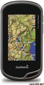
3" sunlight-readable touchscreen display with dual orientation
8 MP autofocus camera with LED flash/torch
Worldwide basemap with shaded relief
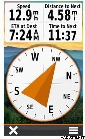
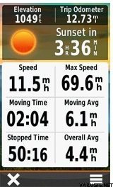
3-axis compass with accelerometer and barometric altimeter sensors
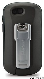
Dual battery — 2 AA batteries or included rechargeable internal NiMH pack
The new rugged and waterproof GPS Oregon series – more features, more power and the most brilliant, sunlight readable touchscreen we’ve ever put on a Garmin handheld.
From the moment you cradle the 650 in your hand, you’re ready to enter into a bold new world of Garmin outdoor navigation. With high-sensitivity GPS and GLONASS satellite tracking (more satellites mean faster fixes, even in challenging environments), preloaded worldwide basemap with shaded relief and a faster processor, you don’t just look at maps, you intuitively interact with them. Zoom in, pan out and rotate using multi-touch in any conditions and even with most gloves. The reflective display technology boosts touchscreen brightness so much that maps and displays are as vivid in full bright sunlight as they are in shade.
Touch and Go
Oregon 650 was purposely engineered for the outdoors. It features the most brilliant, sunlight readable touchscreen we’ve ever put on a Garmin handheld, strengthened for impact resistance but with multi-touch and dual orientation views that still accommodate gloved operation. Bumps, dust, dirt, humidity and water are no match for this mapping-oriented navigator.
Get Your Bearings
Oregon 650 has a built-in 3-axis electronic compass with accelerometer tilt compensation, which shows where you're heading even when you’re standing still, and not holding it level. Its barometric altimeter tracks changes in pressure to pinpoint your precise altitude, and you even can use it to plot barometric pressure over time, which can help you keep an eye on changing weather conditions. And with its high-sensitivity, WAAS/EGNOS and GLONASS-enabled GPS receiver and HotFix® satellite prediction, Oregon 650 locates your position quicker and more precisely and maintains its GPS location even in heavy cover and steep sided valleys.
Double Your Power
Besides its outstanding performance of up to 16 hrs of battery time the new Oregon 650 features our outdoor optimised dual battery system. You’ll have the option of using the internally rechargeable NiMH pack (not included) or traditional AA batteries in case there is no opportunity for charging — The NiMH pack charges automatically whenever the device is connected to external power.
Quality Photos
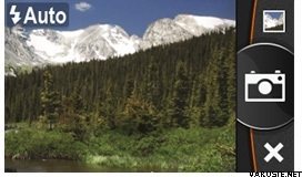
Now you don’t have to take an additional camera with you to take quality photos. Oregon 650's built in 8 megapixel autofocus digital camera takes photos worthy of sharing. And each picture is right away geotagged with the location of where it was taken, allowing you to navigate back to that exact spot in the future. Then share the photos from your Oregon 650 via USB with all your friends through Garmin Adventures, the new online adventure sharing community. For more storage, insert a microSD™ card; you can even view pictures from other devices with Oregon's picture viewer.
Share Wirelessly
Now you can wirelessly transfer large files such as photos, geocaches, routes and Custom Maps between Oregon 600-series devices. Plus, new technology allows your routes, waypoints and tracks to transfer up to 50 times faster. Sync your data such as waypoints, geocaches, tracks and images to the Garmin Cloud, and access from anywhere via your smartphone and BaseCamp mobile app. Oregon is also ANT+ wireless compatible with heart rate, chirp and tempe sensors.
Add Maps
Adding more maps to Oregon is easy. Load our Garmin GB Discoverer™ Ordnance Survey® 1:50k maps or choose our Birdseye™ Select 1:25k Ordnance Survey maps and hit the trail. Plug in BlueChart® g2 preloaded cards for a great day on the water or load City Navigator map data for turn-by-turn routing on roads (see maps tab for compatible maps). Add satellite images to your maps with Birdseye™ Satellite Imagery (subscription required).
You can even display and enter coordinates in British Grid format, the grid used on Ordnance Survey maps.
Load All the Geocaches
No more picking, choosing and planning, just download them all. The Oregon 650 can hold a massive number of geocaches. Not just one thousand, not just one million. Four million. Download every cache on OpenCaching.com. Load caches from GSAK. Or use your favourite program or website supporting GGZ files*. All your paperless geocaching features will be there for every cache. Read full descriptions, hints and logs. View cache photos. Filter caches by size, terrain, difficulty and type. Connect to chirp-enabled caches. Record your logs in the field. Do it all. The Oregon 650 has no limit.
Plan Your Next Trip
Make the most out of your adventures with BaseCamp™, Garmin's free trip planning software. BaseCamp is the perfect environment to comfortably prepare your trips with maps, waypoints, tracks and routes before you get out and once you are home again to create amazing Garmin Adventures to share with friends, family or fellow explorers. The software displays topographic map data in 2-D or 3-D on your computer screen, including contour lines and elevation profiles.
Relive Your Journeys
The BaseCamp mobile Mobile app lets you supplement the Oregon 600 series handheld with the power of your smartphone*. Easily manage and share the waypoints, routes and tracks you've logged on your trail-hardened device. Simply sync the Oregon with your smartphone* to download your data using Bluetooth 4.0 wireless technology. You can upload this trip data to your Garmin Cloud account; the private online storage data centre and access from anywhere. This data can later be used to create your very own Garmin Adventure which allows you to brag to your buddies about your travels or let fellow explorers follow in your footsteps.
Create and Share Adventures
Garmin Adventures provides a free, interactive way to share your hikes, bike rides, road trips and more. Using BaseCamp, you can combine track logs, waypoints, geotagged photos, YouTube® videos and more into an adventure that gets published online. You can then email a link to your adventure to friends and family, share it on social media sites or even post it in your favourite forums. BaseCamp even makes it easy to follow in the footsteps of other travellers by allowing you to search for and download adventures.
The approximate size of the packed product or the sales package is 160 x 180 x 80 mm.
该产品只能通过以下方法交付:- 到店提货
- 按约定时间送货上门 (Matkahuolto Kotijakelu)
- 按约定时间送货上门 (Posti Home Parcel)
- 从自提点取货 (Matkahuolto)
- 从自提点取货 Posti
- 从自提点取货 (PostNord)
- 从R-kioski或K-Market自提点取货 (DB Schenker)
- 挂号信件
- 欧标托盘, 在营业时间内
- 欧标托盘, 在约定时间
- 送货上门 (DB Schenker)
- 送货上门 (Matkahuolto Jakopaketti)
- 送货上门 (Posti)
- 送货上门 (Posti 上午)
- 推货车, 在营业时间内
- 推货车, 在约定时间
- 宅急送 (DHL Express Worldwide)
- 专用托盘
- Pickup from parcel locker (Posti)
- Pickup from parcel locker (PostNord)
- Posti freight to doorstep
24 个月
评价Add a comment
品牌
 评论
评论


 — 显示原文