
Garmin
191 товарів

| Загальна оцінка | (4 відгуки) |
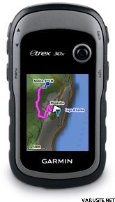
Handheld GPS with 3-axis Compass, Enhanced Display and Preloaded Mapping
eTrex 30x is our upgraded version of the popular eTrex 30, with enhanced screen resolution and extended internal memory to hold more maps. The preloaded Garmin ActiveMap supports and enhances a range of outdoor activities, such as hiking, geocaching, cycling, mountaineering and fishing. eTrex 30x has superior features compared to eTrex 30, while maintaining its ease-of-use, affordability and legendary durability.
See the Way
eTrex 30x has an enhanced 2.2 inch, 65K colour, sunlight-readable display. Durable and water-resistant, eTrex 30x is built to withstand the elements. It has an upgraded interface yet retains its toughness to withstand dust, dirt, humidity or water.
New Tools for Your Trek
The new in-built 3-axis tilt-compensated electronic compass keeps your bearings even when you’re standing still or not holding it level. Also added is a barometric altimeter that tracks changes in pressure to pinpoint your altitude. Use it to plot barometric pressure over time to help you keep an eye on changing weather conditions.
Go Anywhere
Fit your eTrex 30x just about anywhere, using an array of compatible mounts. Use the auto mount capability and City Navigator NT® maps for turn-by-turn driving directions, or the rugged mount for your bike or quad. You can even mount to a boat for fishing or sailing trips.
Go Global
The eTrex series can track both GPS and GLONASS satellites simultaneously – it has the ability to lock on to 24 more satellites than using just GPS. What’s more, the time it takes to “lock on” to a position is (on average) 20% faster than using GPS alone. With its high-sensitivity EGNOS-enabled GPS receiver and HotFix satellite prediction, eTrex locates your position quickly and precisely and maintains its GPS location even in heavy cover and deep valleys.
Preloaded Garmin ActiveMap
eTrex 30x comes preloaded with the new Garmin ActiveMap of Western Europe, a perfect starting point for your first recreational activity with GPS. The map provides relevant useful information for activities like hiking and cycling, it's routable and shows elevation changes*. Garmin ActiveMap Western Europe covers the following countries: Albania, Andorra, Austria, Belgium, Denmark, Finland, France, Germany, Iceland, Ireland, Italy, Liechtenstein, Luxembourg, Malta, Monaco, Netherlands, Norway, Portugal, San Marino, Spain, Sweden, Switzerland, United Kingdom and the Vatican City.
Use the microSD™ card slot to load additional advanced maps – like Topo maps, BlueChart® g2 marine maps or City Navigator® NT maps. eTrex 30x also supports BirdsEye Satellite Imagery (subscription required) to download and integrate with your maps.
Share Wirelessly
eTrex 30x lets you share your routes, geocaches and other user data wirelessly with other compatible devices. Simply press “send” to transfer your information and share your adventure with friends.
eTrex also connects to compatible Garmin devices, including VIRB™ and accessory sensors, including tempe™, foot pod and heart rate monitor.
Keep Your Fix
With its high-sensitivity, EGNOS-enabled GPS receiver and HotFix satellite prediction, eTrex locates your position quickly and precisely and maintains its GPS location even in heavy cover and deep valleys.
Find Fun
eTrex 30x supports paperless geocaching GPX files for endless geocaching adventures. Just visit Take control of your next adventure with BaseCamp™. The free, trip-planning software allows you to view and organise maps, routes and more, and even create Garmin Adventures to share with friends, family or fellow explorers. BaseCamp displays topographic map data in 2D or 3D on your computer screen, as well as a vast array of satellite images when paired with a BirdsEye Satellite Imagery subscription.
* Garmin ActiveMap is based on OSM mapping data, map quality depends heavily on local mapping coverage, Garmin cannot guarantee the quality and completeness of mapping data
Physical & Performance
Physical dimensions5.4 x 10.3 x 3.3 cm
Display size, WxH3.5 x 4.4 cm; 2.2" diag (5.6 cm)
Display resolution, WxH240 x 320 pixels
Display type2.2" transflective, 65K colour TFT
Weight141.7 g with batteries
Battery2 AA batteries (not included); NiMH or Lithium recommended
Battery lifeUp to 25 hours
Water ratingIPX7
High-sensitivity receiver
InterfaceUSB
Camera
No
Barometric altimeter
Electronic compass
Unit-to-unit transfer (shares data wirelessly with similar units)
Maps & Memory
Basemap
Preloaded maps
Yes - Garmin ActiveMap of Western or Eastern Europe
Ability to add maps
Built-in memory3.7 GB including preloaded maps
Accepts data cardsmicroSD™ card (not included)
Custom POIs (ability to add additional points of interest)
Waypoints/favorites/locations2000
Routes200
Track log10,000 points, 200 saved tracks
Outdoor Features
Automatic routing (turn by turn routing on roads)Yes (with optional mapping for detailed roads)
Geocaching-friendlyYes (Paperless)
Custom maps compatible
Sun and moon information
Tide tablesYes (with optional Bluechart)
Area calculation
Picture viewer
Garmin Connect®
Garmin Connect™ compatible (online community where you analyze, categorize and share data)
 Тайвань
| Загальна оцінка | ☆☆☆☆☆ |
 — Показати оригінал
| Загальна оцінка |
— Показати оригінал
Чудовий навігаційний пристрій!| Загальна оцінка |
— Показати оригіналЯкість Garmin, працює! — Показати оригіналМинулого літа пристрою вистачило на одну 10-денну поїздку на руці та 3 дні в дикій місцевості Північної Карелії, після чого на екрані з'явилася загадкова помилка. Екран мав темну пікселізацію по всьому периметру. Я повернув його в Garmin і отримав новий. Відповіді від виробника не було, тому я не знаю, що стало причиною помилки. У мене є деякі сумніви щодо якості пристрою для майбутніх поїздок. Я підозрюю, що пристрій не витримає вологості в довгостроковій перспективі. За час власного використання пристрій не кидав чи щось подібне. Він використовувався лише під час дощу та шторму.