Garmin
195 produktov

| Celkové hodnotenie | (4 hodnotenia/hodnotení) |
The expanded wireless capabilities of Oregon 750 make it easier than ever to update software, check the weather radar2 and upload adventures to Garmin Connect. You can even share LiveTrack location data or geocache discoveries via WiFi or smartphone. Smart Notifications via Bluetooth connectivity with a compatible smartphone let you receive emails, texts and alerts right on your device. So you can see what’s going on while you’re getting away from it all. Comes standard with a dual battery system that lets you use traditional AA batteries or a rechargeable NiMH power pack.
The wireless connectivity to Geocaching.com on your Oregon makes it easier than ever to enjoy a superior geocaching experience. You can set your device to automatically stay up to date with all the latest caches. No more manual entry of coordinates or printing out cache details on paper.
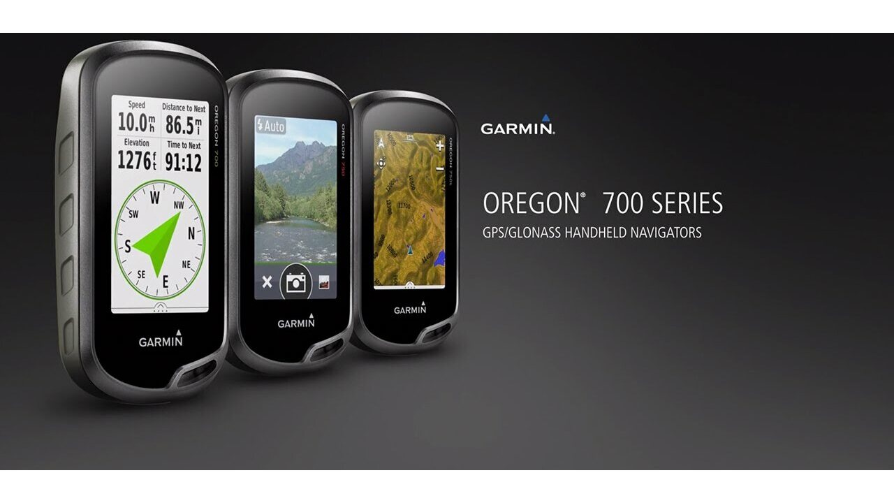
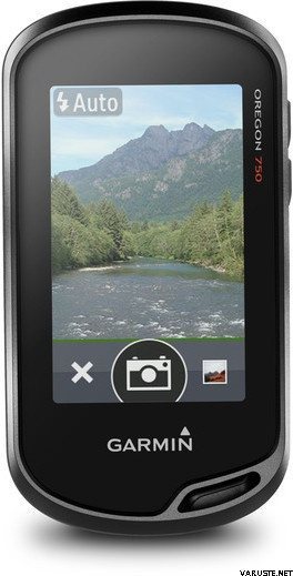
Capture locations and memories with the 8 megapixel digital camera. Each photo is automatically geotagged, allowing you to easily navigate back to that exact spot in the future. You can upload and share your favourite photos with friends via Garmin Adventures™, part of the Garmin online community.
The Oregon 750 handheld provides comprehensive navigation and tracking to guide you on and off the beaten path, using GPS and GLONASS plus ABC (altimeter, barometer and compass) sensor capabilities. The built-in altimeter provides elevation data to accurately monitor ascent and descent, while the barometer can be used to predict weather changes by showing short-term trends in air pressure. The 3-axis electronic compass keeps your bearing, whether you’re moving or not. There’s also a TracBack® feature on Oregon 750 to help you navigate back to your starting point the same way you came. You can also mark locations, such as your campsite, vehicle or other points of interest, to which you'd like return navigation.
The Oregon 750 handheld features a bright, sunlight-readable 3-inch colour touchscreen display with dual orientation for landscape or portrait views. It easily supports multiple mapping options such asBlueChart® g2 HD for water navigation or City Navigator® for turn-by-turn driving directions. Durable and water-rated to IPX7, the Oregon series is built to keep delivering vital mapping and tracking data, no matter what the elements throw at you. Plus, you can even customise your Oregon’s display with free downloads from the Garmin Connect IQ™ online store3.
Take charge of your next adventure with BaseCamp™, software that lets you view and organise maps, waypoints, routes and tracks. This free trip-planning software even allows you to create Garmin Adventures that you can share with friends, family or fellow explorers online. BaseCamp displays on your computer screen any topographic map data stored on the device, including contour lines and elevation profiles. It also can transfer an almost unlimited amount of satellite images to your device from the included BirdsEye Satellite Imagery subscription.
1When paired with a compatible smartphone. See garmin.com/ble for compatibility.
2Active Weather is available in the UK, Ireland, Portugal, Spain, France, Germany, Belgium, Netherlands, Luxembourg, Switzerland, Denmark, Norway, Sweden, Finland, Austria and Slovenia with partial coverage in Northern Italy.
3Apps, widgets and data fields will be introduced when they become available; not all products may be available all the time. Please check ourwebsite for current inventory of Connect IQ products.
The Bluetooth® word mark and logos are registered trademarks owned by Bluetooth SIG, Inc. Wi-Fi® is a registered trademark of the Wi-Fi Alliance.
Physical & Performance |
|
| Physical dimensions | 6.1 x 11.4 x 3.3 cm |
|---|---|
| Display size, WxH | 3.8 x 6.3 cm; 3" diag (7.6 cm) |
| Display resolution, WxH | 240 x 400 pixels |
| Display type | Transflective colour TFT touchscreen |
| Touchscreen | |
| Weight |
209.8 g with batteries |
| Battery | Rechargeable NiMH pack (included) or 2 AA batteries (not included); NiMH or Lithium recommended |
| Battery life | Up to 16 hours |
| Water rating | IPX7 |
| High-sensitivity receiver | |
| Interface | high-speed USB and NMEA 0183 compatible |
| Camera |
Yes (8 megapixel with autofocus; digital zoom) |
| Barometric altimeter | |
| Electronic compass | Yes (tilt-compensated 3-axis) |
| Unit-to-unit transfer (shares data wirelessly with similar units) | Yes (plus images and custom maps) |
Maps & Memory |
|
| Basemap | |
|---|---|
| Preloaded maps |
No |
| Ability to add maps | |
| Built-in memory | 4 GB |
| Accepts data cards | microSD™ card up to 32 GB (not included) |
| Custom POIs (ability to add additional points of interest) | |
| Waypoints/favorites/locations | 10,000 |
| Routes | 250 |
| Track log | 20,000 points, 250 saved tracks |
Outdoor Features |
|
| Automatic routing (turn by turn routing on roads) | Yes (with optional mapping for detailed roads) |
|---|---|
| Geocaching-friendly | Yes (Paperless) |
| Custom maps compatible | |
| Hunt/fish calendar | |
| Sun and moon information | |
| Tide tables | |
| Area calculation | |
| Picture viewer | |
Garmin Connect™ |
|
| Garmin Connect™ compatible (online community where you analyze, categorize and share data) | |
|---|---|
Additional |
|
| Additional |
|
|---|---|
 Taiwan
| Celkové hodnotenie | ☆☆☆☆☆ |
 — Zobraziť pôvodný text
| Celkové hodnotenie |
— Zobraziť pôvodný textHodnota za peniaze nie je uspokojivá. Raz som išiel do záručného servisu, pretože niekedy to vždy zhaslo. Často mrzne.| Celkové hodnotenie |
— Zobraziť pôvodný textKúpil som si ho ako náhradu za moje predchádzajúce série 60 Garmin GEP, ktoré začali trčaním trikov. Pri mojom vlastnom hlavnom použití pri výcviku po psíkovi je najdôležitejšia čo najpresnejšia reprodukovateľnosť stopy, a tam to funguje, rovnako ako moje vynikajúce zariadenie série 60. Nemám rád geocaching, takže funkcie s ním spojené sú mi nanič.
Najhoršou vecou na zariadení je úplne nešťastná výdrž batérie. Aj keď sa to vždy snažím nabiť tesne predtým, ako vyrazím do terénu, už po pár hodinách úroveň rezervácie klesla na nízku úroveň. Na dlhšie cesty si netrúfam stále ho mať zapnutý, ale zapnem ho, len keď cítim, že to potrebujem, a fotoaparát vôbec nepoužívam. Vždy musia byť k dispozícii náhradné batérie.
Vďaka Bluetooth sa zariadenie spája s Garmin Connect, ale zdá sa, že Basecamp a Express vyžadujú USB kľúč, nefungujú na BT ani cez wifi. V skutočnosti som neprišiel na to, kde by sa tu wifi vôbec dalo použiť (wifi funguje samo, to znamená, že nájde sieť, ale tie vlastné softvéry od Garminu sa chmúrne iba cez ventilátor ??)
Zhrnutie: Zariadenie, ktoré by inak bolo v poriadku, ale zlá výdrž batérie ho nepríjemne zhoršuje. Trochu príliš veľa funkcií na úkor spoľahlivej prevádzky. Fotoaparát je zbytočný, najmä preto, že jeho použitie spotrebuje ešte viac batérií, takže teraz by som si kúpil lacnejší bezkamerový model sám.| Celkové hodnotenie |
— Zobraziť pôvodný textKvalita Garmin, funguje!