Garmin
195 produktów

| Ogólna ocena | (4 ocen(y)) |
The expanded wireless capabilities of Oregon 750 make it easier than ever to update software, check the weather radar2 and upload adventures to Garmin Connect. You can even share LiveTrack location data or geocache discoveries via WiFi or smartphone. Smart Notifications via Bluetooth connectivity with a compatible smartphone let you receive emails, texts and alerts right on your device. So you can see what’s going on while you’re getting away from it all. Comes standard with a dual battery system that lets you use traditional AA batteries or a rechargeable NiMH power pack.
The wireless connectivity to Geocaching.com on your Oregon makes it easier than ever to enjoy a superior geocaching experience. You can set your device to automatically stay up to date with all the latest caches. No more manual entry of coordinates or printing out cache details on paper.
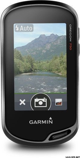
Capture locations and memories with the 8 megapixel digital camera. Each photo is automatically geotagged, allowing you to easily navigate back to that exact spot in the future. You can upload and share your favourite photos with friends via Garmin Adventures™, part of the Garmin online community.
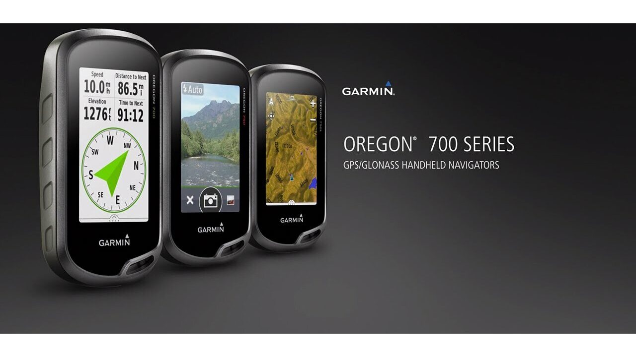
The Oregon 750 handheld provides comprehensive navigation and tracking to guide you on and off the beaten path, using GPS and GLONASS plus ABC (altimeter, barometer and compass) sensor capabilities. The built-in altimeter provides elevation data to accurately monitor ascent and descent, while the barometer can be used to predict weather changes by showing short-term trends in air pressure. The 3-axis electronic compass keeps your bearing, whether you’re moving or not. There’s also a TracBack® feature on Oregon 750 to help you navigate back to your starting point the same way you came. You can also mark locations, such as your campsite, vehicle or other points of interest, to which you'd like return navigation.
The Oregon 750 handheld features a bright, sunlight-readable 3-inch colour touchscreen display with dual orientation for landscape or portrait views. It easily supports multiple mapping options such asBlueChart® g2 HD for water navigation or City Navigator® for turn-by-turn driving directions. Durable and water-rated to IPX7, the Oregon series is built to keep delivering vital mapping and tracking data, no matter what the elements throw at you. Plus, you can even customise your Oregon’s display with free downloads from the Garmin Connect IQ™ online store3.
Take charge of your next adventure with BaseCamp™, software that lets you view and organise maps, waypoints, routes and tracks. This free trip-planning software even allows you to create Garmin Adventures that you can share with friends, family or fellow explorers online. BaseCamp displays on your computer screen any topographic map data stored on the device, including contour lines and elevation profiles. It also can transfer an almost unlimited amount of satellite images to your device from the included BirdsEye Satellite Imagery subscription.
1When paired with a compatible smartphone. See garmin.com/ble for compatibility.
2Active Weather is available in the UK, Ireland, Portugal, Spain, France, Germany, Belgium, Netherlands, Luxembourg, Switzerland, Denmark, Norway, Sweden, Finland, Austria and Slovenia with partial coverage in Northern Italy.
3Apps, widgets and data fields will be introduced when they become available; not all products may be available all the time. Please check ourwebsite for current inventory of Connect IQ products.
The Bluetooth® word mark and logos are registered trademarks owned by Bluetooth SIG, Inc. Wi-Fi® is a registered trademark of the Wi-Fi Alliance.
Physical & Performance |
|
| Physical dimensions | 6.1 x 11.4 x 3.3 cm |
|---|---|
| Display size, WxH | 3.8 x 6.3 cm; 3" diag (7.6 cm) |
| Display resolution, WxH | 240 x 400 pixels |
| Display type | Transflective colour TFT touchscreen |
| Touchscreen | |
| Weight |
209.8 g with batteries |
| Battery | Rechargeable NiMH pack (included) or 2 AA batteries (not included); NiMH or Lithium recommended |
| Battery life | Up to 16 hours |
| Water rating | IPX7 |
| High-sensitivity receiver | |
| Interface | high-speed USB and NMEA 0183 compatible |
| Camera |
Yes (8 megapixel with autofocus; digital zoom) |
| Barometric altimeter | |
| Electronic compass | Yes (tilt-compensated 3-axis) |
| Unit-to-unit transfer (shares data wirelessly with similar units) | Yes (plus images and custom maps) |
Maps & Memory |
|
| Basemap | |
|---|---|
| Preloaded maps |
No |
| Ability to add maps | |
| Built-in memory | 4 GB |
| Accepts data cards | microSD™ card up to 32 GB (not included) |
| Custom POIs (ability to add additional points of interest) | |
| Waypoints/favorites/locations | 10,000 |
| Routes | 250 |
| Track log | 20,000 points, 250 saved tracks |
Outdoor Features |
|
| Automatic routing (turn by turn routing on roads) | Yes (with optional mapping for detailed roads) |
|---|---|
| Geocaching-friendly | Yes (Paperless) |
| Custom maps compatible | |
| Hunt/fish calendar | |
| Sun and moon information | |
| Tide tables | |
| Area calculation | |
| Picture viewer | |
Garmin Connect™ |
|
| Garmin Connect™ compatible (online community where you analyze, categorize and share data) | |
|---|---|
Additional |
|
| Additional |
|
|---|---|
 Tajwan
| Ogólna ocena | ☆☆☆☆☆ |
 — Pokaż tekst oryginalny
| Ogólna ocena |
— Pokaż tekst oryginalnyStosunek jakości do ceny nie jest zadowalający. Raz poszedłem do serwisu gwarancyjnego, bo czasami zawsze wychodziło. Często zawiesza się.| Ogólna ocena |
— Pokaż tekst oryginalnyKupiłem to, aby zastąpić moje poprzednie geps Garmin z serii 60, które zaczęły się od zablokowanych sztuczek. W moim własnym głównym zastosowaniu, w tresurze po psach, najważniejsza jest możliwie jak najdokładniejsza odtwarzalność toru, i tam to działa, podobnie jak moje doskonałe urządzenie z serii 60. Nie lubię geocachingu, więc funkcje z nim związane są dla mnie bezużyteczne.
Najgorszą rzeczą w urządzeniu jest całkowicie niefortunna żywotność baterii. Chociaż zawsze staram się go naładować tuż przed wyruszeniem w teren, już po kilku godzinach poziom naładowania spadł do niskiego poziomu. Podczas dłuższych podróży nie śmiem włączać go przez cały czas, ale włączam go tylko wtedy, gdy czuję, że tego potrzebuję i w ogóle nie używam aparatu. Zapasowe baterie muszą być zawsze obecne.
Dzięki Bluetooth urządzenie łączy się w parę z Garmin Connect, ale Basecamp i Express wydają się wymagać pamięci USB, nie działają przez BT ani przez Wi-Fi. W rzeczywistości nie doszedłem do wniosku, gdzie w ogóle użyć tego wifi tutaj (wifi działa samo w sobie, to znaczy znajduje sieć, ale oprogramowanie Garmina tylko mrocznie przez wentylator?)
Podsumowując: urządzenie, które w innym przypadku byłoby dobrze, ale słaba żywotność baterii sprawia, że jest irytująco zła. Trochę za dużo funkcji kosztem niezawodnego działania. Aparat jest bezużyteczny, zwłaszcza że jego użytkowanie zużywa jeszcze więcej baterii, więc teraz sam kupiłbym tańszy model bez aparatu.| Ogólna ocena |
— Pokaż tekst oryginalnyJakość Garmin działa!