Garmin
195 produktów

| Ogólna ocena | (13 ocen(y)) |
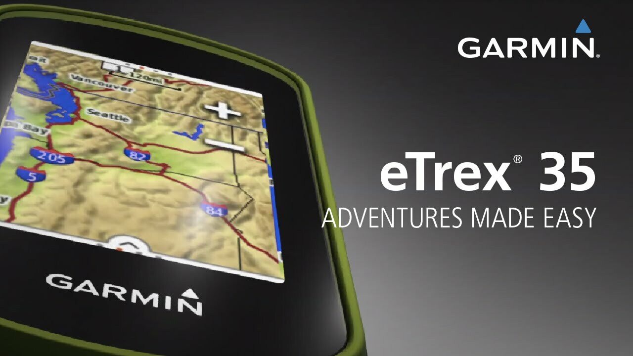
eTrex Touch 35 is the new family navigator for outdoor activities and alpine adventures, ideal for everyone that likes to dip their toes into the great outdoors - from casual cyclists and hikers to geocaching newbies and hillwalkers.
eTrex has been the world’s most popular and successful recreational GPS series for the past 15 years. eTrex Touch 35 is its newest member, that is now easier and more convenient to use than ever. With additional altimeter, it also supports alpine activities like mountaineering and mountain biking. It comes with preinstalled TopoActive Europe maps and optimised Activity Profiles for various recreational activities, not forgetting 250,000 geocaches for endless fun outdoors. With smart notifications straight to your device from your smartphone1, you can stay connected when you’re on the go. To make it even easier to get going, a cycling mount is included in the box. Get out there and have fun with the family. eTrex will guide you every step of the way.
Garmin family navigator that’s easy and fun to use, with touchscreen, altimeter and preloaded TopoActive Europe maps
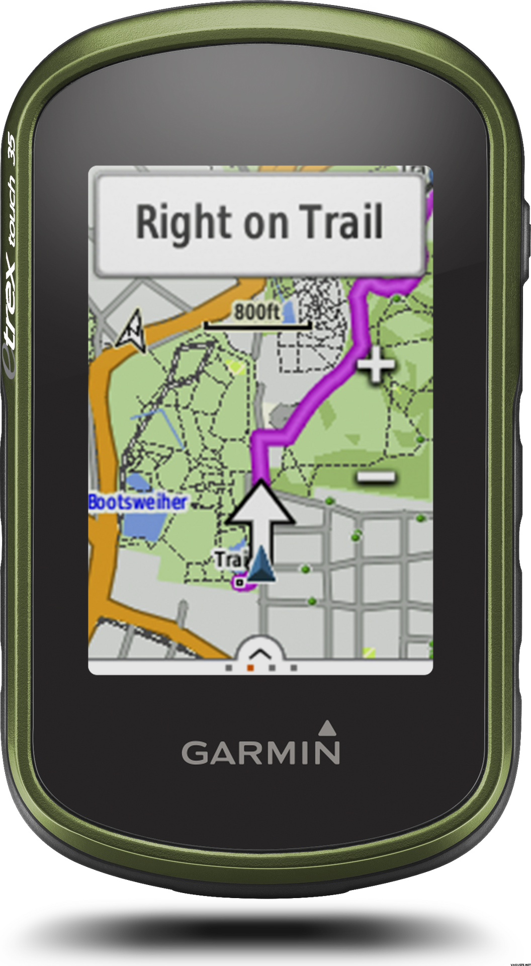
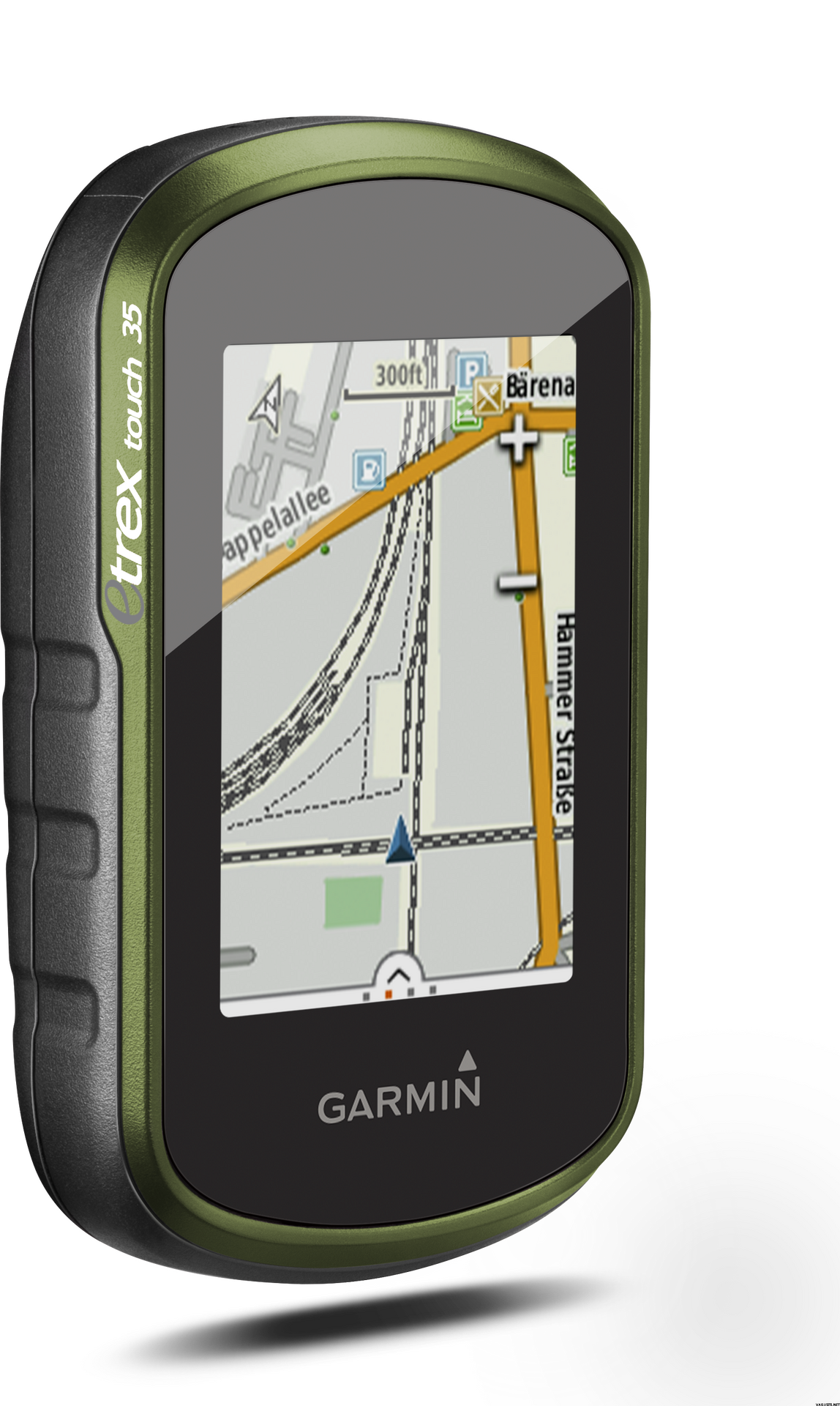
Find your way the easy way
eTrex Touch works like an in-car sat nav, but with maps and features specifically designed for navigation during recreational activities like cycling and hiking. Whether you have a specific destination in mind, or you just want to record your activities to share later on, eTrex Touch gives you the freedom to explore with confidence. You can even find and download activities others have completed on Garmin Connect and Garmin Adventures, or share your own with the community.
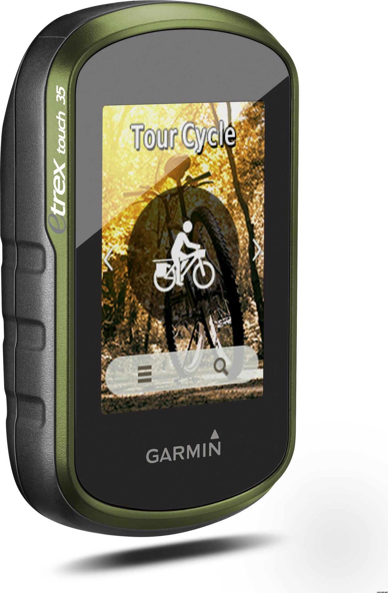
With an easy to use touchscreen, the kids will be able to have a go too. Just touch and go, as the moment takes you! The Activity Profiles give you immediate access to customised profiles like hiking, cycling and geocaching, so you’re all set up for your chosen activity, with everything you need at your fingertips. You can focus on enjoying the great outdoors, and having a great time with your family – knowing you’re in safe hands.
All ready and set to ride
eTrex Touch holds no one back, it’s everything you need to get out there and experience the outdoors at every opportunity. Not only is it designed to enhance whatever activity you fancy that day but it comes fully prepared for you to take it straight out the box and get going.
With a cycling mount included, the eTrex Touch is particularly appealing to recreational cyclists, who can easily fix the device to their handlebars.
The device comes preloaded with Garmin TopoActive Europe maps for 46 countries - just switch the device on, connect to GPS and start navigation. And the maps can be updated at no additional cost. With a large 8 GB internal memory and a microSD slot, there’s plenty of room for additional mapping, whether you’d like to enhance it with advanced topo maps or marine maps.
Dive into geocaching
Experience the great outdoor GPS treasure hunt called geocaching. With the eTrex Touch, geocaching is convenient for everyone, with paperless geocache directions, ratings and recent logs saved directly on the device - no need to print anything.
eTrex Touch 35 comes with an electronic compass that shows you the direction to your destination even while you’re stood still - which helps a lot during short breaks on geocaching adventures.
For beginners, eTrex Touch holds 250,000 great geocaches suitable for those new to geocaching – to help you get used to the whole concept. All geocaches are from geocaching.com, the world’s largest geocaching platform.
Adventures unearthed and shared
Don’t have a specific destination or route in mind? Search for recommended adventures on Garmin Connect or Garmin Adventures, and see routes and geocaches that others have completed. Then download them to eTrex Touch ready for your next adventure. Or create and customise a completely new route to download to your device.
Want to save and re-live a recent adventure? eTrex Touch records where you’ve been so you can upload your routes to Garmin Connect or Garmin Adventures and relive them whenever you want. Garmin Connect and Garmin Adventures are free and allow you to share your recreational adventures with friends and family.
Rock solid eTrex quality
eTrex Touch is the latest product from the famous eTrex GPS handheld series. These products have been successfully deployed all over the earth, from the freezing poles to the heat of African deserts and the humid South American jungles. eTrex has mastered all terrains and the eTrex Touch offers that same toughness and endurance.
eTrex Touch supports GPS and GLONASS, giving you the power of two satellite systems, for faster fix and better accuracy in challenging environments. Let eTrex do all the hard work for you – just check your actual position and follow the guidance. eTrex 35 also adds a barometric altimeter to the mix, for safer navigation in alpine environments and accurate elevation data.
The device is fully ruggedised, IPX7 water-rated and has a scratch-resistant screen. The long 16 hour battery life and field-replaceable standard AA batteries guarantee flexibility when you’re on the go.
eTrex Touch also provides all of the classic eTrex features like hunting and fishing information, sport watch, sun and moon calendar, sunrise and sunset data and much more.
Compact and versatile companion
The handy device fits easily into a pocket or on a handlebar. It’s also designed to be a size that allows kids to easily handle it too. Using the spine mount mounting system, eTrex Touch can be mounted pretty much anywhere with specialised mounts for boats, cars, backpacks etc.
Stay connected
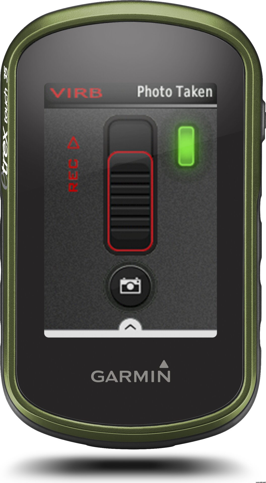
eTrex Touch 35 lets you share your waypoints, tracks, routes and geocaches wirelessly, through unit-to-unit sharing with compatible Garmin devices. With the smart notification feature, you’ll never miss a text, email or notification from your compatible smartphone*, unless you want to. You can also use your eTrex Touch 35 as a remote control for our VIRB® XE, VIRB X and VIRB Elite action cameras.
eTrex Touch 35 also supports Live Track which allows your friends and family to follow your activities in real time. Invite followers, via email or social media, to track your activity and location on Garmin Connect.
Physical & Performance
Physical dimensions5.8 x 10.2 x 3.3 cm
Display size, WxH3.6 x 5.5 cm
Display resolution, WxH160 x 240 pixels
Display type2.6" 65K colour TFT
Touchscreen
Weight159 g with batteries
Battery2 AA batteries (not included); NiMH or Lithium recommended
Battery lifeUp to 16 hours
Water ratingIPX7
High-sensitivity receiver
InterfaceUSB
Camera
No
Barometric altimeter
Electronic compass
Unit-to-unit transfer (shares data wirelessly with similar units)
Maps & Memory
Basemap
Preloaded maps
No
Ability to add maps
Built-in memory8 GB
Accepts data cardsmicroSD™ card (not included)
Custom POIs (ability to add additional points of interest)
Waypoints/favorites/locations4000
Routes200
Track log10,000 points, 200 saved tracks
Outdoor Features
Automatic routing (turn by turn routing on roads)Yes (with optional mapping for detailed roads)
Geocaching-friendlyYes (Paperless)
Custom maps compatible
Sun and moon information
Tide tablesYes (with optional Bluechart)
Area calculation
Picture viewer
Garmin Connect™
Garmin Connect™ compatible (online community where you analyze, categorize and share data)
Additional
Additional
Smart Notifications: Yes
Live Tracking: Yes (with Garmin Connect™ Mobile)
 Tajwan
 — Pokaż tekst oryginalny
 — Pokaż tekst oryginalny
Dobrze, że aplikacja jest gotowa na karcie pamięci. W razie potrzeby można go również pobrać ze strony internetowej National Land Survey of Finland. Garmin eTrex to wygodny rozmiar. Rozmiar ma znaczenie, duzi nie zawsze chcą go nawet zabrać ze sobą. Do urządzenia nie dołączono fińskiej instrukcji obsługi. Można go znaleźć w Internecie, a także z tego miejsca drukować.W przypadku urządzenia zakupionego w Finlandii należy założyć, że dołączona jest instrukcja obsługi, najlepiej jeszcze w kolorze. Najdłużej działają akumulatory. Warto je kupić, nie są zawarte w dostawie, o czym wiadomo już przy składaniu zamówienia.| Ogólna ocena |
— Pokaż tekst oryginalnyDobre i dokładne urządzenie. Dość złożone menu, więc nie nauczyłem się jeszcze wszystkich funkcji.| Ogólna ocena |
— Pokaż tekst oryginalnyUrządzenie kupiłem przede wszystkim do geocachingu i wtórnie do jazdy na rowerze. Szukałem małego urządzenia z ekranem dotykowym o dobrej żywotności baterii i to zostało wybrane. Przyzwyczajenie się do logiki nawigacji w menu zajęło trochę czasu, ale zaczęło znajdować niezbędne funkcje i ustawienia. Małe urządzenie, ale wystarczająco wyraźne na ekranie i mapie. Osobiście mam trochę bólu podczas pobierania pamięci podręcznych na moje urządzenie (pojedynczo z przeglądarki komputera na urządzenie). Prawdopodobnie byłoby bardziej przydatne w przypadku zapytania Geocaching’s Pocket, gdyby istniało członkostwo premium. Będziesz wtedy częściej wprowadzać współrzędne pamięci podręcznej do Garmin i przeglądać opisy pamięci podręcznej w telefonie. W kolarstwie Garmin miał zastąpić telefon nawigacją i mieć przy sobie zapasowe zasilacze. Dołączony stojak na rowery jest w porządku, chociaż jest mocowanie do opaski kablowej. Funkcje nawigacyjne, przynajmniej w połączeniu z miastem, nie są najlepsze, jakie mogą być. Przed zakupem Garmina lubiłem zaplanować przejażdżkę rowerem po nowych obszarach za pomocą Google Maps i przenieść się na telefon. Nie jest łatwo, przynajmniej na pierwszy rzut oka, zaplanować trasę w programie Garmin Base Camp (na komputerze) lub po wprowadzeniu bezpośrednio do urządzenia. Być może z tego powodu musiałem wtedy zrobić więcej w nawigacji telefonu jako asystent pętli rowerowych, nawet przy niewielkim wysiłku i nauce, aby doprowadzić Garmina do znośnego poziomu.| Ogólna ocena |
— Pokaż tekst oryginalnyDziała dobrze. Jednak gdy wydawało się, że odległość, którą pokonywałem, czy to z powodu silnego mrozu, była moc w grzejnikach.| Ogólna ocena |
— Pokaż tekst oryginalnyOK, podstawowe geps. Ekran nie jest zbyt dziwny w porównaniu z telefonem komórkowym, ale zapewnia pewność i bezpieczeństwo podczas dłuższych podróży.| Ogólna ocena |
— Pokaż tekst oryginalnyUrządzenie o wygodnych rozmiarach i łatwe w obsłudze po krótkiej praktyce. Mocowanie do wypełniacza jest miłym dodatkiem i pomaga podczas rowerowego wyszukiwania trasy.
Przeznaczony głównie do użytku w Geocaching. Dostawa była szybka, a firma była już znana, wszystko działa dobrze.| Ogólna ocena |
— Pokaż tekst oryginalnyPoręczny gadżet. Początkowo dostałem go do geocachingu, ale wydaje się, że jest ustawiony na kierownicy roweru, aby dać informacje i pokazać mapę ... będzie więcej prochu w udach, aby wyglądać :) W geocaching ekran wydawał się jakoś za mały, ale może też się do tego przyzwyczaisz. Co zaskakujące, podczas jazdy na rowerze informacje są widoczne, a mapa jest łatwa do odczytania.
Tak, wymaga dużo baterii, więc od razu dostałem akumulatory i ładowarkę. Dobry gadżet!| Ogólna ocena |
— Pokaż tekst oryginalnyNaprawdę wszechstronny nawigator sportowy. Używam go głównie do jazdy na rowerze górskim, ale sprawdza się również podczas wędrówek i jazdy na nartach.| Ogólna ocena |
— Pokaż tekst oryginalnyDobre, ale wymaga czasu na szkolenie w zakresie tych bogatych profili i menu.