
Tracker
8 produktów

| Ogólna ocena | (2 ocen(y)) |
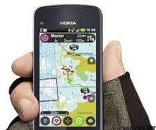
Tracker for Android is the mobile application for hunting, rescue organizations, geocaching, navigation and other outdoor hobbies. It includes navigation on offline topographic maps and roadmaps, compass, real time tracking of dogs, other animals and friends, creating groups and sharing targets as waypoints, routes and lines. Afterwards you can replay and analyse your trip or hunt both on your phone or tablet and your computer after registering on tracker.fi.
The trial version includes all services, for 14 days. Afterwards you can purchase a daily license for 1,99¤, a yearly license for 59 ¤ or use the app for free with limited service.
Mobile phones and mobile data services are exploding - clear future for Tracker!
The App Tracker for Android App together with Tracker G400 and Tracker G500 Black Magnum show hunters, rangers, police departments, rescue organisations, Red Cross and many other users a new dimension of tracking and organisation of a hunt or a rescue operation. The enthusiasm about the new possibilities brings the users to dropping off the offline handhelds and radiofrequency-tracking devices and changing for better and sustainable GPRS technology.
Experience dog tracking like never before:
Track unlimited number of dogs in real time (up to every 3 seconds) with Tracker’s world’s best dog tracking collars - Tracker G400 and Tracker G500 Black Magnum*
Automatic sending and receiving of the positions - no position requests needed
Calling to the dog's collar and listening background noise
Bark indicator updates with every position on status bar and track
Geofence and barking allarms
Unlimited tracking distance
Real time tracking of unlimited number of friends with Tracker for Android App
Targets can be displayed on terrain maps, street maps or compass
Free global maps like openstreetmaps and OSM based Tracker Topo terrain maps as standard
Great quality national maps for Finland, Sweden, Norway, Estonia, Germany, France, Spain and many more
Offline maps for areas with bad network coverage or abroad
Real time tracking and replay mode are available in webtracking on PC as well
Sharing the targets with smart Tracker group function
Every user and collar is secured with share name and password
* tracking is available only with activated and valid license
Map features
Unlimited download of OpenStreetMap based Tracker Topo maps worldwide. They are containing terrain details and elevation contours. Maps are updated once per day.
Trial version contains 100 map tiles of national terrain maps. The paid version contains free national terrain map from Finland, Germany and USA.
Possibility to purchase map tiles for national Swedish, Norwegian, French, Spanish and Italian maps
The maps are downloaded automatically and stored in the memory card, so the App can be used also offline
Navigation and smart draw and measure tool
Add waypoints and select from variety of symbols according to your needs "Meeting point", "car", "tent", "raised hide" etc. and share with your friends
Small compass directly in the map view, large compass appears after clicking on the symbol
Plan your routes and find the places with coordinates
Check the distance to your target with sophisticated distance measuring tool
Draw a route you want to go or a polygon like hunting area or area for rescue operation
The unique tracker group function
Create a group with your friends, dogs and share waypoints, lines or routes
Track your friends and dogs and see each other on the map
Higher security during hunting and rescue action because of real time overview about positions of the others
Chat within group, without SMS costs
Manage your group
My observation book - coming soon!
Mark the exact point of your observation or quarry
add all details your need, like number of species, location and time
Leave a note and share with your hunting friends
Wild animal counter: Note the number of observed animal arts and use it for your yearly hunting plan
Rescue operations in different dimension - no distance limitation, always in touch:
Create a group on your PC with Webtracking in PC or directly in the App
Mark the range borders as polygons and share with your rescue team
Keep the overview over the situation with real time tracking of your rescue team
Replay the rescue operation again step-by-step anytime you want in your mobile phone, tablet or PC.
Replay and Statistics
The unique replay feature: select any date and time when you have used the system and playback the performance minute by minute.
Only with one click you get information about your own position like speed, altitude, direction, GPS, GSM and battery status and age of the position
GPS Odometer gives statistics about your average speed, your walked distance, moving time etc.
 Finlandia