
Garmin
192 producten

| Algemene waardering | (20 recensies) |
Rugged, Full-featured Handheld with GPS, GLONASS and Wireless Connectivity
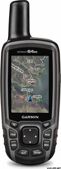
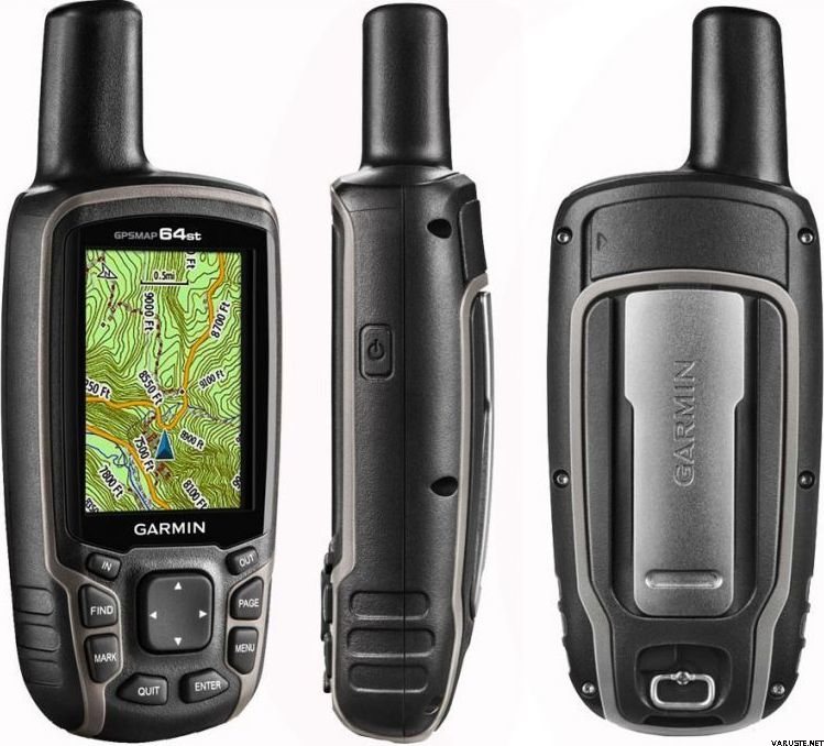
2.6" sunlight-readable color screen
High-sensitivity GPS and GLONASS receiver with quad helix antenna
1-year BirdsEye Satellite Imagery subscription
3-axis compass with barometric altimeter
Wireless connectivity via Bluetooth® technology¹ or ANT+™
GPSMAP 64s
GPSMAP 64s features a 2.6” sunlight-readable color screen and a high-sensitivity GPS and GLONASS receiver with a quad helix antenna for superior reception. GPSMAP 64s includes a 3-axis electronic compass with barometric altimeter, wireless connectivity and a 1-year BirdsEye Satellite Imagery subscription.
Get Your Bearings
GPSMAP 64s has a built-in 3-axis tilt-compensated electronic compass, which shows your heading even when you’re standing still, without holding it level. Its barometric altimeter tracks changes in pressure to pinpoint your precise altitude, and you can even use it to plot barometric pressure over time, which can help you keep an eye on changing weather conditions.
Share Wirelessly
Share your waypoints, tracks, routes and geocaches wirelessly with other compatible devices. Your friends can enjoy your favorite hike or cache without waiting for you to plug in to your computer — simply press “send” to transfer your information to another Garmin handheld.
GPSMAP 64st also connects to compatible Garmin devices, including VIRB™ and accessory sensors, including tempe™, foot pod and heart rate monitor.
Stay Connected
With Smart Notification you can wirelessly receive email, texts and alerts from your compatible iPhone® 4s or later. Stay connected without having to dig into your backpack for your smartphone.
Explore the Terrain
GPSMAP 64s comes with a built-in worldwide basemap with shaded relief plus a 1-year BirdsEye Satellite Imagery subscription, so you can navigate anywhere with ease. With photo navigation, you can download geotagged pictures from the Internet and navigate to them.
Keep Your Fix
With its quad helix antenna and high-sensitivity, GPS and GLONASS, receiver, GPSMAP 64s locates your position quickly and precisely and maintains its location even in heavy cover and deep canyons. The advantage is clear — whether you’re in deep woods or just near tall buildings and trees, you can count on GPSMAP 64s to help you find your way when you need it the most.
Add Maps
GPSMAP 64s comes with a built-in worldwide basemap with shaded relief and a 1-year subscription of BirdsEye Satellite Imagery for a photo-realistic view. Adding more maps is easy with our array of detailed topographic, marine and road maps. With 4 GB of onboard memory and microSD™ card slot, you can conveniently download TOPO 24K and 100K maps and hit the trail, plug in BlueChart® g2 preloaded cards for a great day on the water or City Navigator NT® map data for turn-by-turn routing on roads (see maps tab for compatibility). In addition, the 64s is compatible with Garmin Custom Maps, a map format that allows you to transform paper and electronic maps easily into downloadable maps for your device, for free.
Find Fun
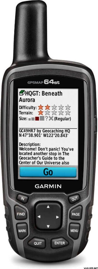
GPSMAP 64s supports paperless geocaching with 250,000 preloaded caches with hints and descriptions from Geocaching.com, and has a 16-hour battery life. By going paperless, you're not only helping the environment, but also improving efficiency. GPSMAP 64s stores and displays key information, including location, terrain, difficulty, hints and descriptions, which means there’s no more manually entering coordinates and paper printouts! Slim and lightweight, 64s is the perfect companion for all your outdoor pursuits.
Plan Your Next Trip
Take charge of your next adventure with BaseCamp™, software that lets you view and organize maps, waypoints, routes and tracks. This free trip-planning software even allows you to create Garmin Adventures that you can share with friends, family or fellow explorers. BaseCamp displays topographic map data in 2-D or 3-D on your computer screen, including contour lines and elevation profiles. It also can transfer an unlimited amount of satellite images to your device when paired with a BirdsEye Satellite Imagery subscription.
 Taiwan
 — Origineel weergeven
 — Origineel weergeven
Allround gps van hoge kwaliteit, weliswaar groot in uw zak om mee te nemen.| Algemene waardering |
— Origineel weergevenGewoon een jepa-gps, maar de interface en structuur voelen op de een of andere manier antiek aan in het tijdperk van de iLure. — Origineel weergevenIk ben zeer tevreden over de Garmin, ik gebruik hem al veel en kom in het interieur van zijn gebruik. Ik heb er een paar dagen later voor besteld
batterij en het is echt waardeloos als het op stroom meegaat dan ongeveer drie uur en de oplaadtijd gaat tot zeven uur vol.
10/18 dat als het de laatste dag van gebruik is, ik helemaal niet verbaasd ben.
TV. Jukka Hakala Suomussalmi| Algemene waardering |
— Origineel weergeven
Abit moeilijk te gebruiken, niet gemakkelijk om kaarten te downloaden en te gebruiken. Eigenlijk nu 1 jaar en heel weinig gebruikt. Alleen voor back-up terwijl off-grid| Algemene waardering |
— Origineel weergevenIk gebruik dit voor caching en ben naar een paar caches gegaan, precies naar de kooien gegaan. Gebruik vereist leren en ik doe nog steeds niet alle onderdelen. Zo zijn de sleutels in de winter goed te dragen, zelfs met een handschoen in de hand. Het scherm is kleiner, maar doet zijn werk. Ik ben wel met mijn mobiele telefoon gekoppeld, maar ik heb de gegevens niet kunnen overzetten! — Origineel weergevenVerkregen als vriend van de oude gpasmap60 omdat de volledige terreinkaart van Finland niet op het oude model geïnstalleerd kon worden. In veel opzichten bevat het apparaat exact dezelfde functies, maar in het oude 60-model denk ik dat de functies beter te vinden zijn vanuit het oogpunt van de gebruiker, dwz daarvoor was de gebruikersinterface niet mooi maar eerder functioneel. In wezen verbeterde nauwkeurigheid (?) Omdat ook de glonass maar terwijl in de meter soms kilometers opstapelt en de oorzaak nog niet definitief is vastgesteld. hopelijk komt hiervoor een software-update.| Algemene waardering |
— Origineel weergevenStevig spel en accuraat. De schermresolutie is echter vergelijkbaar met die van Nokia-telefoons uit de jaren negentig.| Algemene waardering |
— Origineel weergevenIk raad meer veilige functionaliteit aan dan een mobiele telefoon!| Algemene waardering |
— Origineel weergevenZeer goed en veelzijdig GPS-apparaat. Bij continu gebruik worden zelfs de beste AA-batterijen in minder dan een dag verbruikt. Reservebatterijen inbegrepen!
