
Garmin
195 producten


| Algemene waardering | (70 recensies) |
Rugged, Full-featured Handheld with GPS, GLONASS and Wireless Connectivity
2.6" sunlight-readable color screen
High-sensitivity GPS and GLONASS receiver with quad helix antenna
1-year BirdsEye Satellite Imagery subscription
3-axis compass with barometric altimeter
Wireless connectivity via Bluetooth® technology¹ or ANT+™
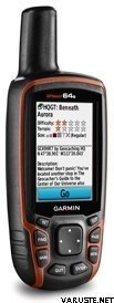
GPSMAP 64s
GPSMAP 64s features a 2.6” sunlight-readable color screen and a high-sensitivity GPS and GLONASS receiver with a quad helix antenna for superior reception. GPSMAP 64s includes a 3-axis electronic compass with barometric altimeter, wireless connectivity and a 1-year BirdsEye Satellite Imagery subscription.
Get Your Bearings
GPSMAP 64s has a built-in 3-axis tilt-compensated electronic compass, which shows your heading even when you’re standing still, without holding it level. Its barometric altimeter tracks changes in pressure to pinpoint your precise altitude, and you can even use it to plot barometric pressure over time, which can help you keep an eye on changing weather conditions.
Share Wirelessly
Share your waypoints, tracks, routes and geocaches wirelessly with other compatible devices. Your friends can enjoy your favorite hike or cache without waiting for you to plug in to your computer — simply press “send” to transfer your information to another Garmin handheld.
GPSMAP 64st also connects to compatible Garmin devices, including VIRB™ and accessory sensors, including tempe™, foot pod and heart rate monitor.
Stay Connected
With Smart Notification you can wirelessly receive email, texts and alerts from your compatible iPhone® 4s or later. Stay connected without having to dig into your backpack for your smartphone.
Explore the Terrain
GPSMAP 64s comes with a built-in worldwide basemap with shaded relief plus a 1-year BirdsEye Satellite Imagery subscription, so you can navigate anywhere with ease. With photo navigation, you can download geotagged pictures from the Internet and navigate to them.
Keep Your Fix
With its quad helix antenna and high-sensitivity, GPS and GLONASS, receiver, GPSMAP 64s locates your position quickly and precisely and maintains its location even in heavy cover and deep canyons. The advantage is clear — whether you’re in deep woods or just near tall buildings and trees, you can count on GPSMAP 64s to help you find your way when you need it the most.
Add Maps
GPSMAP 64s comes with a built-in worldwide basemap with shaded relief and a 1-year subscription of BirdsEye Satellite Imagery for a photo-realistic view. Adding more maps is easy with our array of detailed topographic, marine and road maps. With 4 GB of onboard memory and microSD™ card slot, you can conveniently download TOPO 24K and 100K maps and hit the trail, plug in BlueChart® g2 preloaded cards for a great day on the water or City Navigator NT® map data for turn-by-turn routing on roads (see maps tab for compatibility). In addition, the 64s is compatible with Garmin Custom Maps, a map format that allows you to transform paper and electronic maps easily into downloadable maps for your device, for free.
Find Fun
GPSMAP 64s supports paperless geocaching with 250,000 preloaded caches with hints and descriptions from Geocaching.com, and has a 16-hour battery life. By going paperless, you're not only helping the environment, but also improving efficiency. GPSMAP 64s stores and displays key information, including location, terrain, difficulty, hints and descriptions, which means there’s no more manually entering coordinates and paper printouts! Slim and lightweight, 64s is the perfect companion for all your outdoor pursuits.
Plan Your Next Trip
Take charge of your next adventure with BaseCamp™, software that lets you view and organize maps, waypoints, routes and tracks. This free trip-planning software even allows you to create Garmin Adventures that you can share with friends, family or fellow explorers. BaseCamp displays topographic map data in 2-D or 3-D on your computer screen, including contour lines and elevation profiles. It also can transfer an unlimited amount of satellite images to your device when paired with a BirdsEye Satellite Imagery subscription.
 Taiwan
| Algemene waardering | ☆☆☆☆☆ |
 — Origineel weergeven
 — Origineel weergeven
Voor het eerste gps-apparaat was het moeilijk om in de handleiding precies de instructies te vinden die een beginner nodig heeft. De verpakking mist volledig instructies in het Fins, en om ze online te vinden, heb je een internetverbinding nodig en de vaardigheden die minder bessen boven de 70 hebben zonder de hulp van jongere mensen. Dat wil zeggen, het forest heeft een assistent nodig om het apparaat te gebruiken.| Algemene waardering |
— Origineel weergevenDit kwam als een geschenk aan de zuster voor taken als reddingshond. Het is naar verluidt goed geweest. Vehje was ook betrokken bij onze gezamenlijke Hammastunturi-wandeling en daar bleek dat het overal werkt. Slechts één keer werd op een kruispunt opgemerkt dat het leek alsof de locatie ongeveer 100 meter verkeerd was, maar verder leek het er altijd precies goed uit te zien. — Origineel weergevenRelatief eenvoudig in gebruik, laadt snel op, soms verschijnt er vreemde kilometerstand op de boordcomputer, ook al is het maar een paar honderd meter afgelegd| Algemene waardering |
— Origineel weergevenGoed en eenvoudig apparaat.
Ik kocht een waterstraal als navigatieapparaat, dus ik moest nog eens +150 euro investeren in compatibele waterkaarten en een standaard.
Werkt zoals het hoort en het signaal wordt niet onnodig onderbroken. Waterbestendig.
Kan worden gebruikt met AA-batterijen of NiMH-batterijen en gaat de hele dag licht mee na één keer opladen, zelfs als de helderheid van het scherm vol is.
Waar voor je geld.| Algemene waardering |
— Origineel weergevenDe gebruiksaanwijzing had ook in het Fins moeten zijn. Veelzijdig, betrouwbaar. — Origineel weergevenVrij goed pakket, hoewel op dit moment nog niet erg veel gebruik| Algemene waardering |
— Origineel weergevenVoor buitengebruik, het enige apparaat met batterijen die de hele dag meegaan. Het gebruik is ook mogelijk met handschoenen aan. De schermupdate op de meegeleverde kaart is traag. Het menusysteem was beter in eerdere modellen.| Algemene waardering |
— Origineel weergevenHet heeft goed gewerkt, maar ik heb nog niet veel terrein gehad.| Algemene waardering |
— Origineel weergevenHandige nauwkeurige pleister voor geocaching. Werkt bij zomer- en wintervorst doordat het apparaat sleutelknoppen heeft.
Tevergeefs zijn er die vooraf geladen tradits, ze wanneer je hun onnodige mappen verwijdert en gpx-bestanden downloadt, evenals terreinkaarten, zo een geweldige game.
