Garmin
191 商品

| 一般評価 | (11 評価) |
The wireless connectivity to Geocaching.com on your Oregon makes it easier than ever to enjoy a superior geocaching experience. You can set your device to automatically stay up to date with all the latest caches. No more manual entry of coordinates or printing out cache details on paper.
The expanded wireless capabilities of Oregon 700 make it easier than ever to update software, check the weather radar2 and upload adventures to ourGarmin Connect online community. You can even share LiveTrack location data or geocache discoveries via WiFi or smartphone. Smart Notifications via Bluetooth connectivity with a compatible smartphone let you receive emails, texts and alerts right on your device. So you can see what’s going on while you’re getting away from it all.
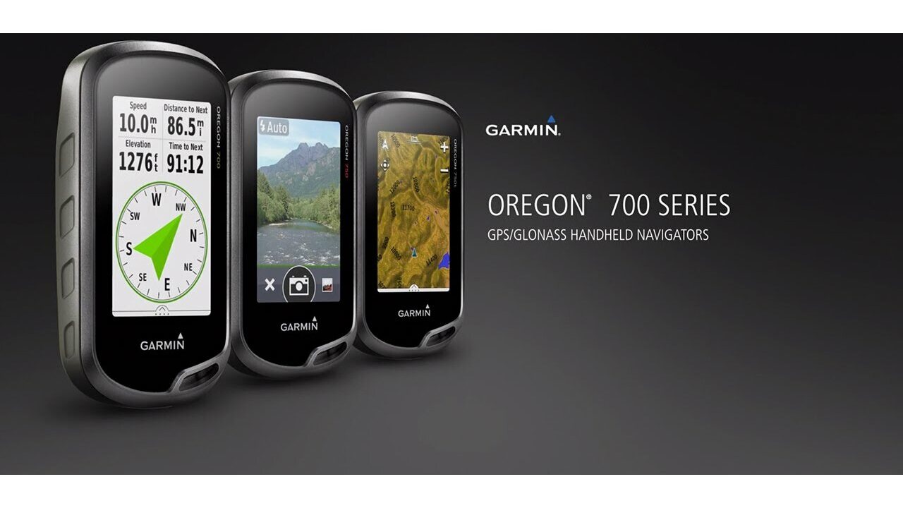
The Oregon 700 handheld provides comprehensive navigation and tracking to guide you on and off the beaten path, using GPS and GLONASS plus ABC (altimeter, barometer and compass) sensor capabilities. The built-in altimeter provides elevation data to accurately monitor ascent and descent, while the barometer can be used to predict weather changes by showing short-term trends in air pressure. The 3-axis electronic compass keeps your bearing, whether you’re moving or not. There’s also a TracBack® feature on Oregon 700 to help you navigate back to your starting point the same way you came. You can also mark locations, such as your campsite, vehicle or other points of interest, to which you'd like return navigation.
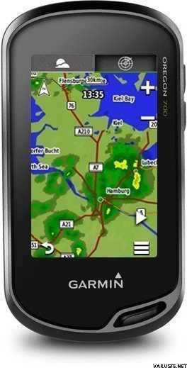
The Oregon 700 handheld features a bright, sunlight-readable 3-inch colour touchscreen display with dual orientation for landscape or portrait views. It easily supports multiple mapping options such asBlueChart® g2 HD for water navigation or City Navigator® for turn-by-turn driving directions. Durable and water-rated to IPX7, the Oregon series is built to keep delivering vital mapping and tracking data, no matter what the elements throw at you. Plus, you can even customise your Oregon’s display with free downloads from the Garmin Connect IQ™ online store3.
Take charge of your next adventure with BaseCamp™, software that lets you view and organise maps, waypoints, routes and tracks. This free trip-planning software even allows you to create Garmin Adventuresthat you can share with friends, family or fellow explorers online. BaseCamp displays on your computer screen any topographic map data stored on the device, including contour lines and elevation profiles. It also can transfer an almost unlimited amount of satellite images to your device using the included BirdsEye Satellite Imagery subscription.
1When paired with a compatible smartphone. See garmin.com/ble for compatibility.
2Active Weather is available in the UK, Ireland, Portugal, Spain, France, Germany, Belgium, Netherlands, Luxembourg, Switzerland, Denmark, Norway, Sweden, Finland, Austria and Slovenia with partial coverage in Northern Italy.
3Apps, widgets and data fields will be introduced when they become available; not all products may be available all the time. Please check ourwebsite for current inventory of Connect IQ products.
The Bluetooth® word mark and logos are registered trademarks owned by Bluetooth SIG, Inc. Wi-Fi® is a registered trademark of the Wi-Fi Alliance.
Physical & Performance |
|
| Physical dimensions | 6.1 x 11.4 x 3.3 cm |
|---|---|
| Display size, WxH | 3.8 x 6.3 cm; 3" diag (7.6 cm) |
| Display resolution, WxH | 240 x 400 pixels |
| Display type | Transflective colour TFT touchscreen |
| Touchscreen | |
| Weight |
209.8 g with batteries |
| Battery | 2 AA batteries (not included); NiMH or Lithium recommended, rechargeable NiMH pack (optional) |
| Battery life | Up to 16 hours |
| Water rating | IPX7 |
| High-sensitivity receiver | |
| Interface | high-speed USB and NMEA 0183 compatible |
| Camera |
No |
| Barometric altimeter | |
| Electronic compass | Yes (tilt-compensated 3-axis) |
| Unit-to-unit transfer (shares data wirelessly with similar units) | Yes (plus images and custom maps) |
Maps & Memory |
|
| Basemap | |
|---|---|
| Preloaded maps |
No |
| Ability to add maps | |
| Built-in memory | 1.7 GB |
| Accepts data cards | microSD™ card up to 32 GB (not included) |
| Custom POIs (ability to add additional points of interest) | |
| Waypoints/favorites/locations | 10,000 |
| Routes | 250 |
| Track log | 20,000 points, 250 saved tracks |
Outdoor Features |
|
| Automatic routing (turn by turn routing on roads) | Yes (with optional mapping for detailed roads) |
|---|---|
| Geocaching-friendly | Yes (Paperless) |
| Custom maps compatible | |
| Hunt/fish calendar | |
| Sun and moon information | |
| Tide tables | |
| Area calculation | |
| Picture viewer | |
Garmin Connect™ |
|
| Garmin Connect™ compatible (online community where you analyze, categorize and share data) | |
|---|---|
Additional |
|
| Additional |
|
|---|---|
 台湾
台湾| 一般評価 | ☆☆☆☆☆ |
 — オリジナルを見る
| 一般評価 |
— オリジナルを見る
これは私が所有する3番目のオレゴンです。主にサイクリングに使用しています。私はこれを 3 番目のものにしました。そのため、ハンドルバー用の新しい固定具を購入したり、新しいシステムを学ぶ必要はありませんでした。私の Oregon 600 よりもずっと長持ちすることを願っています。これは数年後に失敗し、フランスの日差しの下で 1 週間サイクリングした際に 2 つのボタンのゴムが完全に劣化してしまいました。
700 は 600 よりも歌ったり踊ったりします。バッテリーの寿命は短いようです。単三電池が必要なので、今は予備を持ち歩いています。
これらすべてのマイナス点はありますが、私は今でもオレゴンが好きです。使いやすくて画面の大きさも気に入っています。| 一般評価 |
— オリジナルを見る
これは最高の Garmin GPS であり、もはやそれを実現していません。現在のモデルは、GPSMAP66 の標高測定に重大なエラーがあり、ボタンが非常にぎこちなく、モンタナはハイキングに適していないレンガであるため、さらに悪化しています。| 一般評価 |
— オリジナルを見るかなり良い手の石膏。あなたが一滴に耐えられないとき、すでに3番目の同様のものがあります。
太陽が輝くほど明るい画面が最適です。| 一般評価 |
— オリジナルを見る価格と品質の比率は正しいようです。以前のボタン付きナビゲーターに比べて使いやすいです。含まれている地形図はうまく機能します。| 一般評価 |
— オリジナルを見る長時間の旅行ではバッテリーの寿命が短く、太陽の下で画面を使用することはまったく不可能です。ちなみに比較的小さいサイズプラス。残念ながら、Garminの競合相手はいないようですので、ここに行きます。
国土調査は必要な追加をマップします!| 一般評価 |
— オリジナルを見るxTrex 20より前のユーザーエクスペリエンスは良好でしたが、これに比べて多くの改善と地形図の王冠があります。
アジア人。