Garmin
192 商品

| 一般評価 | (20 評価) |
Rugged, Full-featured Handheld with GPS, GLONASS and Wireless Connectivity
2.6" sunlight-readable color screen
High-sensitivity GPS and GLONASS receiver with quad helix antenna
1-year BirdsEye Satellite Imagery subscription
3-axis compass with barometric altimeter
Wireless connectivity via Bluetooth® technology¹ or ANT+™
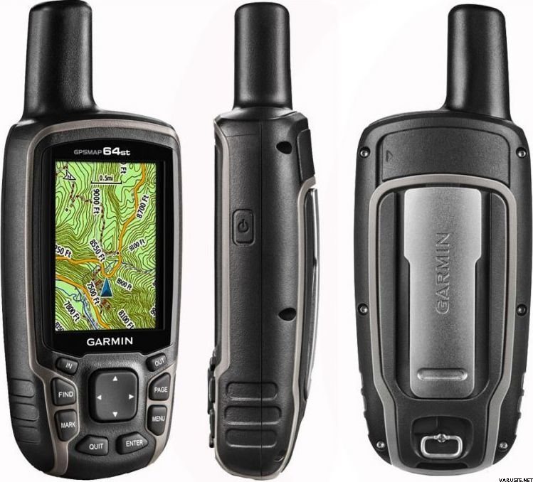
GPSMAP 64s
GPSMAP 64s features a 2.6” sunlight-readable color screen and a high-sensitivity GPS and GLONASS receiver with a quad helix antenna for superior reception. GPSMAP 64s includes a 3-axis electronic compass with barometric altimeter, wireless connectivity and a 1-year BirdsEye Satellite Imagery subscription.
Get Your Bearings
GPSMAP 64s has a built-in 3-axis tilt-compensated electronic compass, which shows your heading even when you’re standing still, without holding it level. Its barometric altimeter tracks changes in pressure to pinpoint your precise altitude, and you can even use it to plot barometric pressure over time, which can help you keep an eye on changing weather conditions.
Share Wirelessly
Share your waypoints, tracks, routes and geocaches wirelessly with other compatible devices. Your friends can enjoy your favorite hike or cache without waiting for you to plug in to your computer — simply press “send” to transfer your information to another Garmin handheld.
GPSMAP 64st also connects to compatible Garmin devices, including VIRB™ and accessory sensors, including tempe™, foot pod and heart rate monitor.
Stay Connected
With Smart Notification you can wirelessly receive email, texts and alerts from your compatible iPhone® 4s or later. Stay connected without having to dig into your backpack for your smartphone.
Explore the Terrain
GPSMAP 64s comes with a built-in worldwide basemap with shaded relief plus a 1-year BirdsEye Satellite Imagery subscription, so you can navigate anywhere with ease. With photo navigation, you can download geotagged pictures from the Internet and navigate to them.
Keep Your Fix
With its quad helix antenna and high-sensitivity, GPS and GLONASS, receiver, GPSMAP 64s locates your position quickly and precisely and maintains its location even in heavy cover and deep canyons. The advantage is clear — whether you’re in deep woods or just near tall buildings and trees, you can count on GPSMAP 64s to help you find your way when you need it the most.
Add Maps
GPSMAP 64s comes with a built-in worldwide basemap with shaded relief and a 1-year subscription of BirdsEye Satellite Imagery for a photo-realistic view. Adding more maps is easy with our array of detailed topographic, marine and road maps. With 4 GB of onboard memory and microSD™ card slot, you can conveniently download TOPO 24K and 100K maps and hit the trail, plug in BlueChart® g2 preloaded cards for a great day on the water or City Navigator NT® map data for turn-by-turn routing on roads (see maps tab for compatibility). In addition, the 64s is compatible with Garmin Custom Maps, a map format that allows you to transform paper and electronic maps easily into downloadable maps for your device, for free.
Find Fun
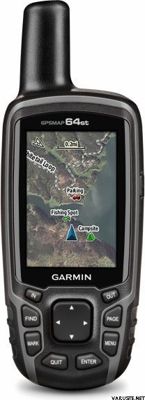
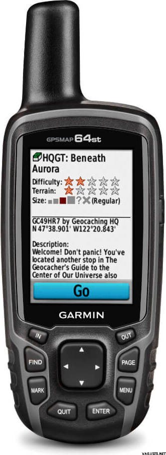
GPSMAP 64s supports paperless geocaching with 250,000 preloaded caches with hints and descriptions from Geocaching.com, and has a 16-hour battery life. By going paperless, you're not only helping the environment, but also improving efficiency. GPSMAP 64s stores and displays key information, including location, terrain, difficulty, hints and descriptions, which means there’s no more manually entering coordinates and paper printouts! Slim and lightweight, 64s is the perfect companion for all your outdoor pursuits.
Plan Your Next Trip
Take charge of your next adventure with BaseCamp™, software that lets you view and organize maps, waypoints, routes and tracks. This free trip-planning software even allows you to create Garmin Adventures that you can share with friends, family or fellow explorers. BaseCamp displays topographic map data in 2-D or 3-D on your computer screen, including contour lines and elevation profiles. It also can transfer an unlimited amount of satellite images to your device when paired with a BirdsEye Satellite Imagery subscription.
 台湾
台湾 — オリジナルを見る
 — オリジナルを見る
持ち運び用のポケットには大きいものの、オールラウンドな高品質のGPS。| 一般評価 |
— オリジナルを見るかなりジェパGPSですが、iLureの時代には、インターフェースと構造はなんとなくアンティークな感じがします。 — オリジナルを見る私はガーミンに非常に満足しています、私はそれをたくさん使っていて、その使用の内部に入ります。数日後に注文しました
バッテリーとそれが約3時間よりも電源で持続し、充電時間が最大7時間になると、それは本当にひどいです。
10/18使用の最終日であれば、私はまったく驚かない。
テレビ。ユッカハカラスオムッサルミ| 一般評価 |
— オリジナルを見る
少し使いづらく、地図をダウンロードして使用するのは簡単ではありません。実は今1年間持っていて、ほとんど使っていません。オフグリッド時のバックアップのみ| 一般評価 |
— オリジナルを見る私はこれをキャッシュに使用し、いくつかのキャッシュに移動したので、まさに猫に連れて行ってくれました。使用には学習が必要ですが、私はまだすべての部分を行っているわけではありません。したがって、冬には手袋をはめた手でもキーを着用するのが良いでしょう。画面は小さいですが、それはその仕事をします。携帯電話とペアリングしましたが、データを転送できませんでした! — オリジナルを見るフィンランドの地形図全体を古いモデルにインストールできなかったため、古いgpasmap60の友人として取得しました。多くの点で、デバイスにはまったく同じ機能が含まれていますが、古い60モデルでは、ユーザーの観点から機能をより適切に見つけることができると思います。つまり、以前はユーザーインターフェイスは見栄えが良くなく機能的でした。基本的に精度が向上しました(?)グロナスもありますが、メーター内にキロメートルが蓄積されることがあり、原因はまだ最終的に特定されていません。うまくいけば、これのためのソフトウェアアップデートがあるでしょう。| 一般評価 |
— オリジナルを見る頑丈なゲームと正確。ただし、画面の解像度は90年代のノキアの携帯電話の解像度と同じです。| 一般評価 |
— オリジナルを見る携帯電話よりも安全な機能をお勧めします!| 一般評価 |
— オリジナルを見る非常に優れた多用途のGPSデバイス。継続使用は、最高の単三電池でさえ1日以内に消費します。予備のバッテリーが含まれています!