納入可能商品は一時的に在庫を切らしております。
在庫状況商品が倉庫に入荷されたら、知らせてほしいです。
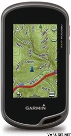
商品説明More Features and Power Behind Our Toughest, Brightest Touchscreen. 3" sunlight-readable touchscreen display (dual orientation). Preloaded TOPO U.S. 100K maps with shaded relief basemap. 3-axis compass with accelerometer and barometric altimeter sensors. Dual battery system — 2 AA batteries or optional rechargeable internal NiMH pack
With high-sensitivity GPS and GLONASS satellite tracking, preloaded TOPO U.S. 100K maps, worldwide basemap with shaded relief and customizable buttons for 1-touch waypoint marking, Oregon 600t opens a new world of GPS mapping and positioning.
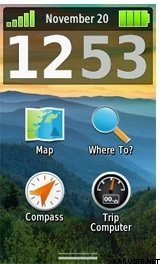
Touch and Go
Oregon 600t has reflective display technology for the most brilliant, sunlight readable touchscreen we’ve ever made. The screen is strengthened for impact resistance, with multi-touch and dual orientation views that accommodate gloved operation.
Double Your Power
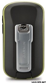
Oregon 600t features our state-of-the-art dual battery system. Use the optional rechargeable NiMH pack (not included) or traditional AA batteries — NiMH pack charges when the device is connected to external power.
Explore the Terrain
Oregon 600t comes with built-in US topographic data for the entire US, including Alaska, Hawaii and Puerto Rico, and a worldwide basemap with shaded relief — all the tools for serious climbing or hiking. Map detail includes national, state and local parks and forests, along with terrain contours, elevation information, trails, rivers, lakes and points of interest.
Get Your Bearings
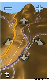
Oregon 600t has a built-in 3-axis electronic compass with accelerometer tilt compensation to show where you're heading even when standing still, or not holding it level. Its barometric altimeter tracks changes in pressure to pinpoint your precise altitude. You can even use it to plot barometric pressure over time to keep an eye on changing weather conditions.
With its high-sensitivity, WAAS- and GLONASS-enabled GPS receiver and HotFix® satellite prediction, Oregon 600t locates your position quickly and precisely, and maintains its GPS location even in heavy cover and deep canyons.
Share Wirelessly
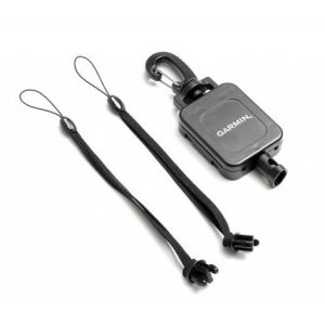
With Oregon 600t you can share your waypoints, tracks, routes and geocaches up to 50 times faster with other wireless compatible Garmin handheld devices. Plus, you can share large files too like photos, Garmin Adventures and Custom Maps. Just touch “send” to transfer your information.
Add Maps
Adding more maps to Oregon is easy. Load TOPO U.S. 24K maps and hit the trail; add Trailhead Series TOPO maps and explore famous treks like the Appalachian Trail and the Pacific Crest Trail; plug in BlueChart® g2 preloaded cards for a great day on the water; or load City Navigator® map data for turn-by-turn routing on roads. Add satellite images to your maps with BirdsEye Satellite Imagery (subscription required).
Load All the Geocaches
No more picking, choosing and planning, just download them all. The Oregon 600t can hold up to 4 million caches. Download every cache on OpenCaching.com. Load caches using your favorite program or website that supports GGZ files. All your paperless geocaching features will be there for every cache. Read full descriptions, hints and logs. View cache photos. Filter caches by size, terrain, difficulty and type. Connect to chirp-enabled caches. Record your logs in the field. The Oregon 600t has no limit.
Plan Your Next Trip
Take charge of your next adventure with BaseCamp™, software that lets you view and organize maps, waypoints, routes and tracks. This free trip-planning software even allows you to create Garmin Adventures that you can share with friends, family or fellow explorers. BaseCamp displays topographic map data in 2-D or 3-D on your computer screen, including contour lines and elevation profiles. It also can transfer an unlimited amount of satellite images to your device when paired with a BirdsEye Satellite Imagery subscription.
大体の商品の大きさ、または製品パッケージの大きさは 160 x 180 x 80 mm.
この商品の配送方法は以下です。 配送方法:- 当店舗でのお引き取り
- Posti freight to doorstep
- R-kioskiまたは Kマーケットの案内所でのお引き取り (DB Schenker)
- お荷物受取り所での受取り (Matkahuolto)
- お荷物受取り所での受取り Posti
- お荷物受取り所での受取り (PostNord)
- ご自宅までの配送 (Matkahuolto Jakopaketti)
- ご自宅までの配送 (Posti)
- ご自宅までの配送 (Posti ユーロ荷台パレット, 営業時間内に)
- ご自宅までの配送 (Posti 運搬台車, 営業時間内に)
- ご自宅までの配送 (Posti 朝)
- ご自宅までの配送 (Posti 特殊パレット)
- フォローアップレター
- 時間指定でのご自宅までの配送 (Matkahuolto Kotijakelu)
- 時間指定でのご自宅までの配送 (Posti Home Parcel)
- 時間指定でのご自宅までの配送 (Posti ユーロ荷台パレット)
- 時間指定でのご自宅までの配送 (Posti 運搬台車)
- 宅配ロッカー受取り (Posti)
- 宅配ロッカー受取り (PostNord)
- 宅配便 (DHL Express Worldwide)
24 ヶ月
コメントコメントを追加する
ブランド商品