Garmin
195 prodotti

| Valutazione generale | (13 recensioni) |
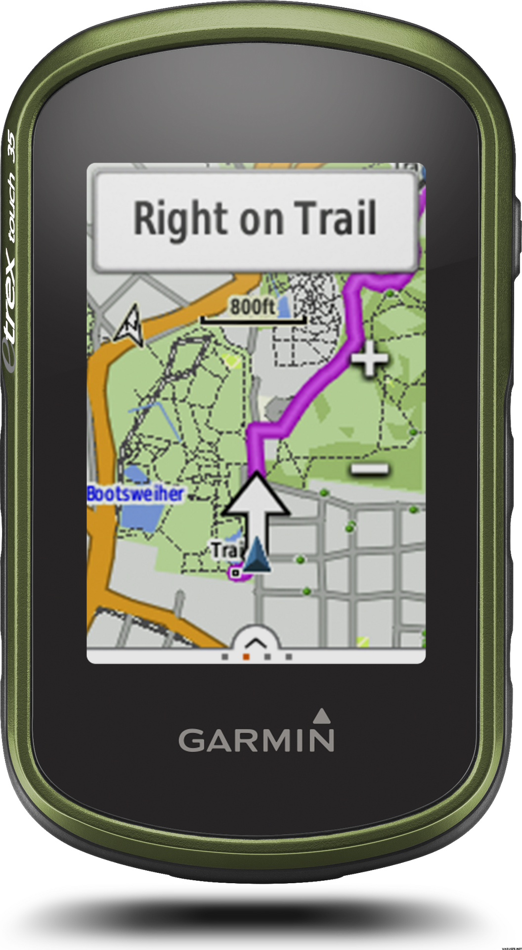
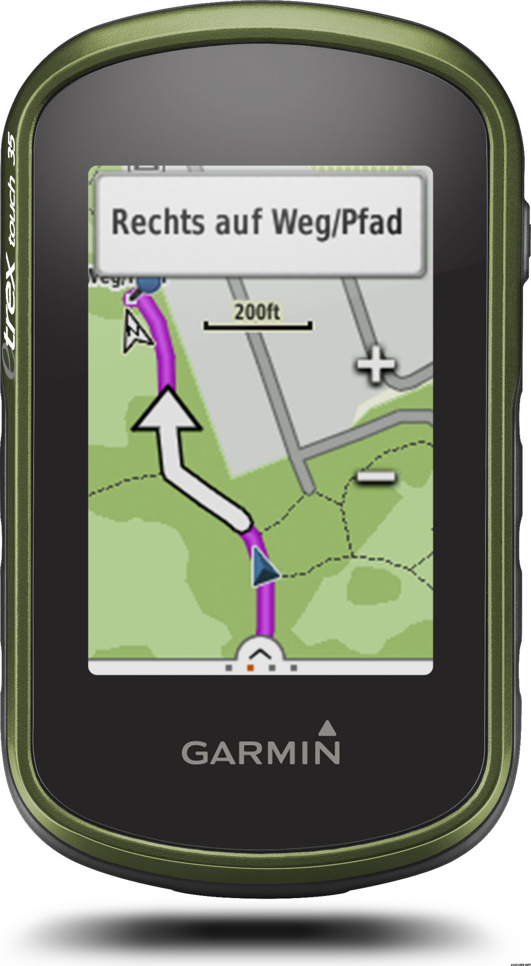
eTrex Touch 35 is the new family navigator for outdoor activities and alpine adventures, ideal for everyone that likes to dip their toes into the great outdoors - from casual cyclists and hikers to geocaching newbies and hillwalkers.
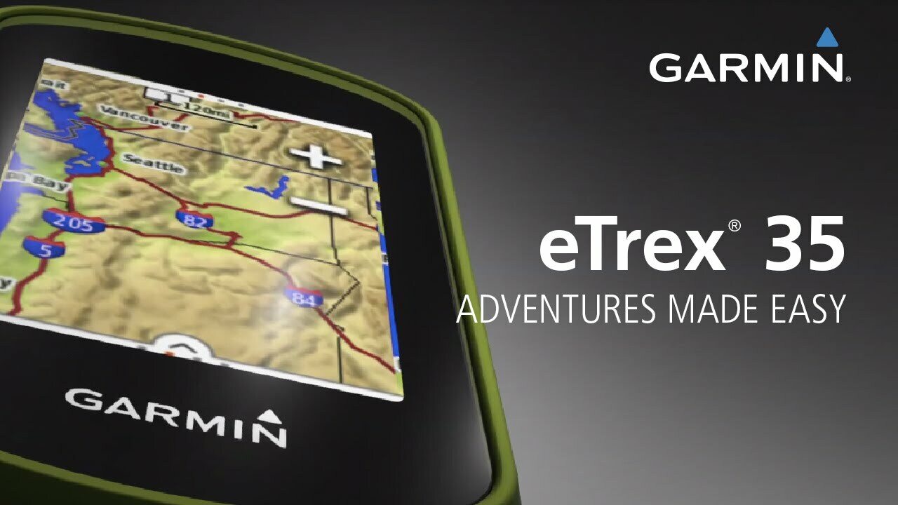
eTrex has been the world’s most popular and successful recreational GPS series for the past 15 years. eTrex Touch 35 is its newest member, that is now easier and more convenient to use than ever. With additional altimeter, it also supports alpine activities like mountaineering and mountain biking. It comes with preinstalled TopoActive Europe maps and optimised Activity Profiles for various recreational activities, not forgetting 250,000 geocaches for endless fun outdoors. With smart notifications straight to your device from your smartphone1, you can stay connected when you’re on the go. To make it even easier to get going, a cycling mount is included in the box. Get out there and have fun with the family. eTrex will guide you every step of the way.
Garmin family navigator that’s easy and fun to use, with touchscreen, altimeter and preloaded TopoActive Europe maps
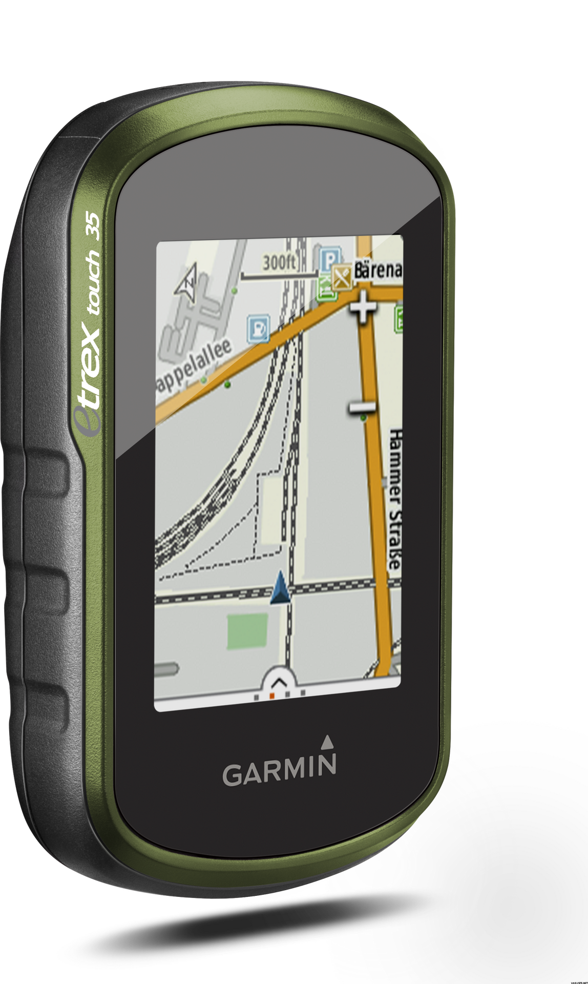
Find your way the easy way
eTrex Touch works like an in-car sat nav, but with maps and features specifically designed for navigation during recreational activities like cycling and hiking. Whether you have a specific destination in mind, or you just want to record your activities to share later on, eTrex Touch gives you the freedom to explore with confidence. You can even find and download activities others have completed on Garmin Connect and Garmin Adventures, or share your own with the community.
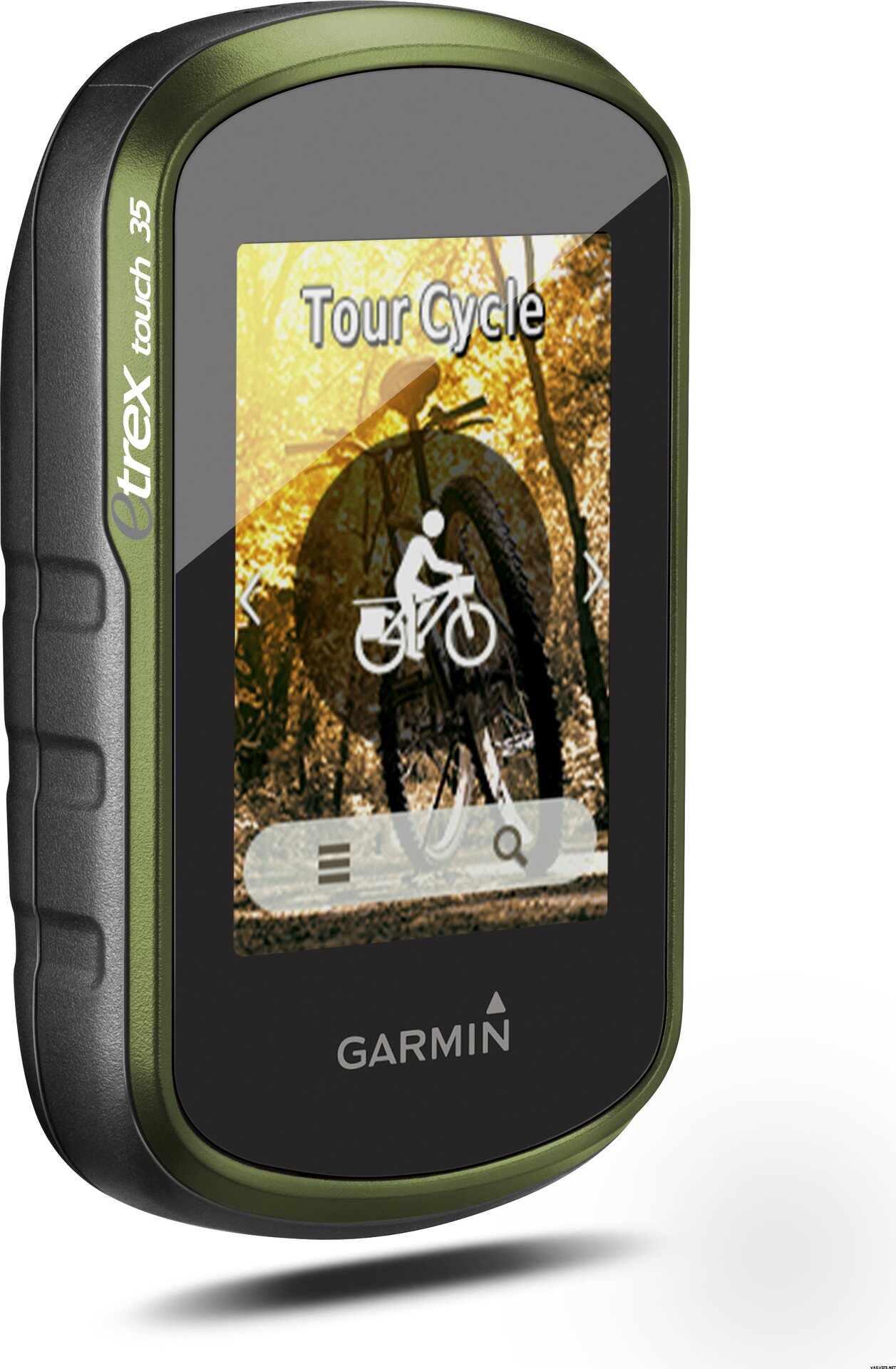
With an easy to use touchscreen, the kids will be able to have a go too. Just touch and go, as the moment takes you! The Activity Profiles give you immediate access to customised profiles like hiking, cycling and geocaching, so you’re all set up for your chosen activity, with everything you need at your fingertips. You can focus on enjoying the great outdoors, and having a great time with your family – knowing you’re in safe hands.
All ready and set to ride
eTrex Touch holds no one back, it’s everything you need to get out there and experience the outdoors at every opportunity. Not only is it designed to enhance whatever activity you fancy that day but it comes fully prepared for you to take it straight out the box and get going.
With a cycling mount included, the eTrex Touch is particularly appealing to recreational cyclists, who can easily fix the device to their handlebars.
The device comes preloaded with Garmin TopoActive Europe maps for 46 countries - just switch the device on, connect to GPS and start navigation. And the maps can be updated at no additional cost. With a large 8 GB internal memory and a microSD slot, there’s plenty of room for additional mapping, whether you’d like to enhance it with advanced topo maps or marine maps.
Dive into geocaching
Experience the great outdoor GPS treasure hunt called geocaching. With the eTrex Touch, geocaching is convenient for everyone, with paperless geocache directions, ratings and recent logs saved directly on the device - no need to print anything.
eTrex Touch 35 comes with an electronic compass that shows you the direction to your destination even while you’re stood still - which helps a lot during short breaks on geocaching adventures.
For beginners, eTrex Touch holds 250,000 great geocaches suitable for those new to geocaching – to help you get used to the whole concept. All geocaches are from geocaching.com, the world’s largest geocaching platform.
Adventures unearthed and shared
Don’t have a specific destination or route in mind? Search for recommended adventures on Garmin Connect or Garmin Adventures, and see routes and geocaches that others have completed. Then download them to eTrex Touch ready for your next adventure. Or create and customise a completely new route to download to your device.
Want to save and re-live a recent adventure? eTrex Touch records where you’ve been so you can upload your routes to Garmin Connect or Garmin Adventures and relive them whenever you want. Garmin Connect and Garmin Adventures are free and allow you to share your recreational adventures with friends and family.
Rock solid eTrex quality
eTrex Touch is the latest product from the famous eTrex GPS handheld series. These products have been successfully deployed all over the earth, from the freezing poles to the heat of African deserts and the humid South American jungles. eTrex has mastered all terrains and the eTrex Touch offers that same toughness and endurance.
eTrex Touch supports GPS and GLONASS, giving you the power of two satellite systems, for faster fix and better accuracy in challenging environments. Let eTrex do all the hard work for you – just check your actual position and follow the guidance. eTrex 35 also adds a barometric altimeter to the mix, for safer navigation in alpine environments and accurate elevation data.
The device is fully ruggedised, IPX7 water-rated and has a scratch-resistant screen. The long 16 hour battery life and field-replaceable standard AA batteries guarantee flexibility when you’re on the go.
eTrex Touch also provides all of the classic eTrex features like hunting and fishing information, sport watch, sun and moon calendar, sunrise and sunset data and much more.
Compact and versatile companion
The handy device fits easily into a pocket or on a handlebar. It’s also designed to be a size that allows kids to easily handle it too. Using the spine mount mounting system, eTrex Touch can be mounted pretty much anywhere with specialised mounts for boats, cars, backpacks etc.
Stay connected
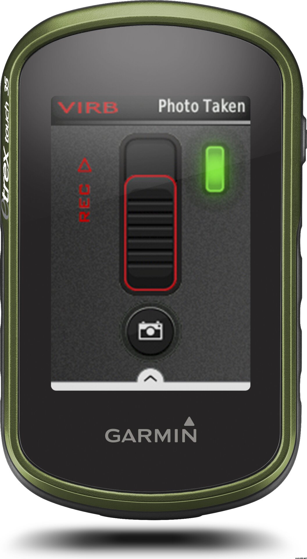
eTrex Touch 35 lets you share your waypoints, tracks, routes and geocaches wirelessly, through unit-to-unit sharing with compatible Garmin devices. With the smart notification feature, you’ll never miss a text, email or notification from your compatible smartphone*, unless you want to. You can also use your eTrex Touch 35 as a remote control for our VIRB® XE, VIRB X and VIRB Elite action cameras.
eTrex Touch 35 also supports Live Track which allows your friends and family to follow your activities in real time. Invite followers, via email or social media, to track your activity and location on Garmin Connect.
Physical & Performance
Physical dimensions5.8 x 10.2 x 3.3 cm
Display size, WxH3.6 x 5.5 cm
Display resolution, WxH160 x 240 pixels
Display type2.6" 65K colour TFT
Touchscreen
Weight159 g with batteries
Battery2 AA batteries (not included); NiMH or Lithium recommended
Battery lifeUp to 16 hours
Water ratingIPX7
High-sensitivity receiver
InterfaceUSB
Camera
No
Barometric altimeter
Electronic compass
Unit-to-unit transfer (shares data wirelessly with similar units)
Maps & Memory
Basemap
Preloaded maps
No
Ability to add maps
Built-in memory8 GB
Accepts data cardsmicroSD™ card (not included)
Custom POIs (ability to add additional points of interest)
Waypoints/favorites/locations4000
Routes200
Track log10,000 points, 200 saved tracks
Outdoor Features
Automatic routing (turn by turn routing on roads)Yes (with optional mapping for detailed roads)
Geocaching-friendlyYes (Paperless)
Custom maps compatible
Sun and moon information
Tide tablesYes (with optional Bluechart)
Area calculation
Picture viewer
Garmin Connect™
Garmin Connect™ compatible (online community where you analyze, categorize and share data)
Additional
Additional
Smart Notifications: Yes
Live Tracking: Yes (with Garmin Connect™ Mobile)
 Taiwan
 — Mostra originale
 — Mostra originale
Bene che l'app sia pronta sulla scheda di memoria. Se necessario, può anche essere scaricato dal sito web del National Land Survey of Finland. Il Garmin eTrex è di dimensioni convenienti. Le dimensioni contano, quelle grandi non vogliono nemmeno portarsele dietro. Il dispositivo non è stato fornito con un manuale utente finlandese. Puoi trovarlo online e puoi anche stampare da lì.Il dispositivo acquistato dalla Finlandia presume che il manuale sia incluso, preferibilmente in stampa a colori. Le batterie ricaricabili durano più a lungo. Vale la pena acquistarli, non inclusi nella consegna, che è già noto al momento dell'ordine.| Valutazione generale |
— Mostra originaleDispositivo buono e preciso. Menu piuttosto complessi, quindi non ho ancora imparato tutte le funzionalità.| Valutazione generale |
— Mostra originaleHo acquistato il dispositivo principalmente per il geocaching e secondariamente per il ciclismo. Stavo cercando un piccolo dispositivo touch screen con una buona durata della batteria e questo è stato selezionato. Ci è voluto un po 'per abituarsi alla logica di navigazione del menu, ma ha iniziato a trovare le funzioni e le impostazioni necessarie. Dispositivo piccolo, ma abbastanza chiaro sullo schermo e sulla mappa. Personalmente, ho un po 'di problemi a scaricare le cache sul mio dispositivo (una alla volta dal browser di un computer a un dispositivo). Probabilmente sarebbe stato più utile con la query Pocket di Geocaching se ci fosse un abbonamento premium. Potrai quindi inserire più spesso le coordinate della cache in Garmin e sfogliare le descrizioni della cache sul tuo telefono. Nel ciclismo, Garmin avrebbe dovuto sostituire il telefono con il navigatore e portare con sé alimentatori di riserva. Il portabiciclette incluso va bene, anche se è presente un fissaggio per fascette. Le funzioni di navigazione, almeno su un collegamento cittadino, non sono le migliori che possono essere. Prima di acquistare un Garmin, mi piaceva pianificare un giro in bicicletta in nuove aree con Google Maps e trasferirlo sul mio telefono. Non è molto facile, almeno a prima vista, pianificare un percorso nel software Base Camp di Garmin (su un computer) o, se inserito direttamente nel dispositivo. Forse per questo motivo, ho dovuto fare di più nella navigazione del telefono come assistente ai loop della bici, anche con un piccolo sforzo e apprendimento, anche portando Garmin a un livello tollerabile.| Valutazione generale |
— Mostra originaleHa funzionato bene. Tuttavia, una volta che sembrava la distanza che stavo percorrendo, indipendentemente dal fatto che fosse dovuto a un forte gelo, c'era energia nei radiatori.| Valutazione generale |
— Mostra originaleOK gep di base. Lo schermo non è molto strano rispetto a un telefono cellulare, ma offre certezza e sicurezza per la navigazione nei viaggi più lunghi.| Valutazione generale |
— Mostra originaleDispositivo di dimensioni convenienti e facile da usare dopo un po 'di pratica. Il fissaggio al riempimento è una bella aggiunta e aiuta quando si cerca un percorso quando si pedala.
Destinato principalmente all'uso in Geocaching. La consegna è stata rapida e l'azienda era già familiare, tutto funziona bene.| Valutazione generale |
— Mostra originaleUn pratico gadget. Inizialmente, l'ho preso per il geocaching, ma sembra essere posizionato sul manubrio della bici per fornire informazioni e mostrare la mappa ... ci sarà più polvere da sparo sulle cosce per assomigliare :) Nel geocaching, lo schermo sembrava in qualche modo troppo piccolo, ma forse ti ci abitui anche tu. Sorprendentemente, quando si pedala, le informazioni sono visibili e la mappa è di facile lettura.
Sì, ci vogliono molte batterie, quindi ho subito ricevuto batterie ricaricabili e un caricabatterie. Buon gadget!| Valutazione generale |
— Mostra originaleUn navigatore sportivo davvero versatile. Lo uso principalmente per la mountain bike, ma funziona anche per l'escursionismo e lo sci.| Valutazione generale |
— Mostra originaleBuono ma richiede tempo di formazione per quei ricchi profili e menu.