Garmin
192 prodotti

| Valutazione generale | (20 recensioni) |
Rugged, Full-featured Handheld with GPS, GLONASS and Wireless Connectivity
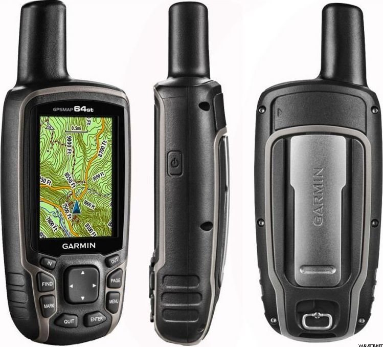
2.6" sunlight-readable color screen
High-sensitivity GPS and GLONASS receiver with quad helix antenna
1-year BirdsEye Satellite Imagery subscription
3-axis compass with barometric altimeter
Wireless connectivity via Bluetooth® technology¹ or ANT+™
GPSMAP 64s
GPSMAP 64s features a 2.6” sunlight-readable color screen and a high-sensitivity GPS and GLONASS receiver with a quad helix antenna for superior reception. GPSMAP 64s includes a 3-axis electronic compass with barometric altimeter, wireless connectivity and a 1-year BirdsEye Satellite Imagery subscription.
Get Your Bearings
GPSMAP 64s has a built-in 3-axis tilt-compensated electronic compass, which shows your heading even when you’re standing still, without holding it level. Its barometric altimeter tracks changes in pressure to pinpoint your precise altitude, and you can even use it to plot barometric pressure over time, which can help you keep an eye on changing weather conditions.
Share Wirelessly
Share your waypoints, tracks, routes and geocaches wirelessly with other compatible devices. Your friends can enjoy your favorite hike or cache without waiting for you to plug in to your computer — simply press “send” to transfer your information to another Garmin handheld.
GPSMAP 64st also connects to compatible Garmin devices, including VIRB™ and accessory sensors, including tempe™, foot pod and heart rate monitor.
Stay Connected
With Smart Notification you can wirelessly receive email, texts and alerts from your compatible iPhone® 4s or later. Stay connected without having to dig into your backpack for your smartphone.
Explore the Terrain
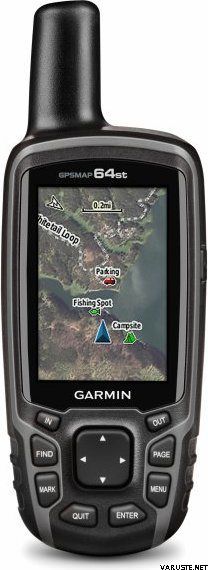
GPSMAP 64s comes with a built-in worldwide basemap with shaded relief plus a 1-year BirdsEye Satellite Imagery subscription, so you can navigate anywhere with ease. With photo navigation, you can download geotagged pictures from the Internet and navigate to them.
Keep Your Fix
With its quad helix antenna and high-sensitivity, GPS and GLONASS, receiver, GPSMAP 64s locates your position quickly and precisely and maintains its location even in heavy cover and deep canyons. The advantage is clear — whether you’re in deep woods or just near tall buildings and trees, you can count on GPSMAP 64s to help you find your way when you need it the most.
Add Maps
GPSMAP 64s comes with a built-in worldwide basemap with shaded relief and a 1-year subscription of BirdsEye Satellite Imagery for a photo-realistic view. Adding more maps is easy with our array of detailed topographic, marine and road maps. With 4 GB of onboard memory and microSD™ card slot, you can conveniently download TOPO 24K and 100K maps and hit the trail, plug in BlueChart® g2 preloaded cards for a great day on the water or City Navigator NT® map data for turn-by-turn routing on roads (see maps tab for compatibility). In addition, the 64s is compatible with Garmin Custom Maps, a map format that allows you to transform paper and electronic maps easily into downloadable maps for your device, for free.
Find Fun
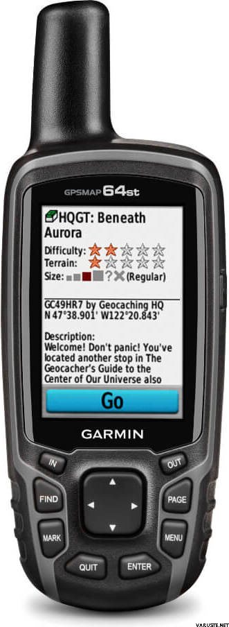
GPSMAP 64s supports paperless geocaching with 250,000 preloaded caches with hints and descriptions from Geocaching.com, and has a 16-hour battery life. By going paperless, you're not only helping the environment, but also improving efficiency. GPSMAP 64s stores and displays key information, including location, terrain, difficulty, hints and descriptions, which means there’s no more manually entering coordinates and paper printouts! Slim and lightweight, 64s is the perfect companion for all your outdoor pursuits.
Plan Your Next Trip
Take charge of your next adventure with BaseCamp™, software that lets you view and organize maps, waypoints, routes and tracks. This free trip-planning software even allows you to create Garmin Adventures that you can share with friends, family or fellow explorers. BaseCamp displays topographic map data in 2-D or 3-D on your computer screen, including contour lines and elevation profiles. It also can transfer an unlimited amount of satellite images to your device when paired with a BirdsEye Satellite Imagery subscription.
 Taiwan
 — Mostra originale
 — Mostra originale
Gps a tutto tondo di alta qualità, anche se capiente da portare in tasca.| Valutazione generale |
— Mostra originaleSolo un GPS jepa, ma l'interfaccia e la struttura sembrano in qualche modo antiquate nell'era di iLure. — Mostra originaleSono molto contento di Garmin, l'ho già usato molto e sono entrato a usarlo. Ho ordinato da te pochi giorni dopo per quello
batteria ed è davvero pessimo quando dura solo per circa tre ore e il tempo di ricarica completo arriva fino a sette ore.
10/18 che se è l'ultimo giorno di utilizzo non mi stupisco affatto.
TV. Jukka Hakala Suomussalmi| Valutazione generale |
— Mostra originale
Abit difficile da usare, non facile da scaricare mappe e da usare. In realtà, ce l'ho da 1 anno e l'ho usato pochissimo. Solo per il backup fuori dalla rete| Valutazione generale |
— Mostra originaleLo uso per la memorizzazione nella cache e, essendo passato a poche cache, ho esattamente preso le gabbie. L'uso richiede apprendimento e ancora non faccio tutte le parti. Quindi, in inverno le chiavi sono buone da indossare anche in un guanto. Lo schermo è più piccolo, ma fa il suo lavoro. Mi sono accoppiato con il mio telefono cellulare, ma non sono stato in grado di trasferire i dati! — Mostra originaleAcquistato come amico del vecchio gpasmap60 perché l'intera mappa del terreno della Finlandia non poteva essere installata sul vecchio modello. Per molti aspetti, il dispositivo contiene esattamente le stesse funzioni, ma nel vecchio modello 60, penso che le funzioni possano essere trovate meglio dal punto di vista dell'utente, cioè prima l'interfaccia utente non era bella ma piuttosto funzionale. Precisione sostanzialmente migliorata (?) Perché anche glonass ma quando il contatore è presente a volte accumula chilometri e la causa non è ancora stata determinata in modo definitivo. si spera che ci sarà un aggiornamento software per questo.| Valutazione generale |
— Mostra originaleGioco robusto e preciso. Tuttavia, la risoluzione dello schermo è simile a quella dei telefoni cellulari Nokia degli anni novanta.| Valutazione generale |
— Mostra originaleRaccomando funzionalità più sicure di un telefono cellulare!| Valutazione generale |
— Mostra originaleDispositivo GPS molto buono e versatile. L'uso continuo consuma anche le migliori batterie AA in meno di un giorno. Batterie di ricambio incluse!