Garmin
191 termék

| Összesített értékelés | (11 értékelések) |
The wireless connectivity to Geocaching.com on your Oregon makes it easier than ever to enjoy a superior geocaching experience. You can set your device to automatically stay up to date with all the latest caches. No more manual entry of coordinates or printing out cache details on paper.
The expanded wireless capabilities of Oregon 700 make it easier than ever to update software, check the weather radar2 and upload adventures to ourGarmin Connect online community. You can even share LiveTrack location data or geocache discoveries via WiFi or smartphone. Smart Notifications via Bluetooth connectivity with a compatible smartphone let you receive emails, texts and alerts right on your device. So you can see what’s going on while you’re getting away from it all.
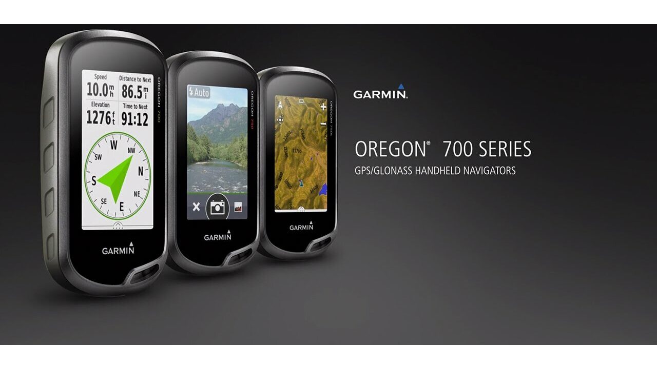
The Oregon 700 handheld provides comprehensive navigation and tracking to guide you on and off the beaten path, using GPS and GLONASS plus ABC (altimeter, barometer and compass) sensor capabilities. The built-in altimeter provides elevation data to accurately monitor ascent and descent, while the barometer can be used to predict weather changes by showing short-term trends in air pressure. The 3-axis electronic compass keeps your bearing, whether you’re moving or not. There’s also a TracBack® feature on Oregon 700 to help you navigate back to your starting point the same way you came. You can also mark locations, such as your campsite, vehicle or other points of interest, to which you'd like return navigation.
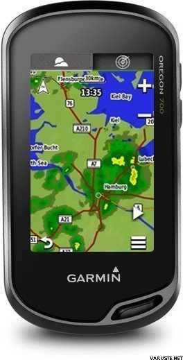
The Oregon 700 handheld features a bright, sunlight-readable 3-inch colour touchscreen display with dual orientation for landscape or portrait views. It easily supports multiple mapping options such asBlueChart® g2 HD for water navigation or City Navigator® for turn-by-turn driving directions. Durable and water-rated to IPX7, the Oregon series is built to keep delivering vital mapping and tracking data, no matter what the elements throw at you. Plus, you can even customise your Oregon’s display with free downloads from the Garmin Connect IQ™ online store3.
Take charge of your next adventure with BaseCamp™, software that lets you view and organise maps, waypoints, routes and tracks. This free trip-planning software even allows you to create Garmin Adventuresthat you can share with friends, family or fellow explorers online. BaseCamp displays on your computer screen any topographic map data stored on the device, including contour lines and elevation profiles. It also can transfer an almost unlimited amount of satellite images to your device using the included BirdsEye Satellite Imagery subscription.
1When paired with a compatible smartphone. See garmin.com/ble for compatibility.
2Active Weather is available in the UK, Ireland, Portugal, Spain, France, Germany, Belgium, Netherlands, Luxembourg, Switzerland, Denmark, Norway, Sweden, Finland, Austria and Slovenia with partial coverage in Northern Italy.
3Apps, widgets and data fields will be introduced when they become available; not all products may be available all the time. Please check ourwebsite for current inventory of Connect IQ products.
The Bluetooth® word mark and logos are registered trademarks owned by Bluetooth SIG, Inc. Wi-Fi® is a registered trademark of the Wi-Fi Alliance.
Physical & Performance |
|
| Physical dimensions | 6.1 x 11.4 x 3.3 cm |
|---|---|
| Display size, WxH | 3.8 x 6.3 cm; 3" diag (7.6 cm) |
| Display resolution, WxH | 240 x 400 pixels |
| Display type | Transflective colour TFT touchscreen |
| Touchscreen | |
| Weight |
209.8 g with batteries |
| Battery | 2 AA batteries (not included); NiMH or Lithium recommended, rechargeable NiMH pack (optional) |
| Battery life | Up to 16 hours |
| Water rating | IPX7 |
| High-sensitivity receiver | |
| Interface | high-speed USB and NMEA 0183 compatible |
| Camera |
No |
| Barometric altimeter | |
| Electronic compass | Yes (tilt-compensated 3-axis) |
| Unit-to-unit transfer (shares data wirelessly with similar units) | Yes (plus images and custom maps) |
Maps & Memory |
|
| Basemap | |
|---|---|
| Preloaded maps |
No |
| Ability to add maps | |
| Built-in memory | 1.7 GB |
| Accepts data cards | microSD™ card up to 32 GB (not included) |
| Custom POIs (ability to add additional points of interest) | |
| Waypoints/favorites/locations | 10,000 |
| Routes | 250 |
| Track log | 20,000 points, 250 saved tracks |
Outdoor Features |
|
| Automatic routing (turn by turn routing on roads) | Yes (with optional mapping for detailed roads) |
|---|---|
| Geocaching-friendly | Yes (Paperless) |
| Custom maps compatible | |
| Hunt/fish calendar | |
| Sun and moon information | |
| Tide tables | |
| Area calculation | |
| Picture viewer | |
Garmin Connect™ |
|
| Garmin Connect™ compatible (online community where you analyze, categorize and share data) | |
|---|---|
Additional |
|
| Additional |
|
|---|---|
 Tajvan
| Összesített értékelés | ☆☆☆☆☆ |
 — Eredeti szöveg megtekintése
| Összesített értékelés |
— Eredeti szöveg megtekintése
Ez a harmadik Oregon, ami a tulajdonomban van. Főleg kerékpározáshoz használom. Ezt a harmadikat kaptam, így nem kellett új rögzítést vásárolnom a kormányomhoz, és nem kellett új rendszert tanulnom. Remélem, sokkal tovább bírja, mint az Oregon 600-am. Ez pár év után meghiúsult, amikor a két gomb gumija teljesen leromlott egyhetes kerékpározás során a francia napsütésben.
A 700 többet énekel és táncol, mint a 600. Az akkumulátor élettartama kevesebbnek tűnik. AA elem kell hozzá, és most viszek magammal tartalékokat.
Mindezen negatívumok ellenére továbbra is szeretem az Oregont. Használata egyszerű, és tetszik a képernyő mérete.| Összesített értékelés |
— Eredeti szöveg megtekintése
Ez a legjobb Garmin GPS, és már nem gyártják. A jelenlegi modellek sokkal rosszabbak, mert a GPSMAP66-ban komoly hibák vannak a magasságmérésben, és a gombok nagyon esetlenek, és a montana egy tégla, ami nem jó túrázáshoz.| Összesített értékelés |
— Eredeti szöveg megtekintéseNagyon jó kézi vakolat. Már van egy harmadik hasonló, amikor egy cseppet sem bírsz elviselni. A legjobb az a képernyő, amely annál fényesebb, minél jobban süt a nap.| Összesített értékelés |
— Eredeti szöveg megtekintéseÚgy tűnik, hogy az ár-minőség arány megfelelő. Könnyen használható az előző gombos navigátoromhoz képest. A mellékelt Tereptérkép jól működik.| Összesített értékelés |
— Eredeti szöveg megtekintéseAz akkumulátor élettartama alacsony hosszabb utazások esetén, és a képernyőt meglehetősen lehetetlen használni napsütésben. Egyébként viszonylag kicsi plusz. Sajnos úgy tűnik, hogy nincsenek versenytársai a Garminnak, így ez a helyes út. Az Országos Földmérés feltérképezi a szükséges kiegészítést!| Összesített értékelés |
— Eredeti szöveg megtekintéseA felhasználói élmény pozitív volt az xTrex 20 előtt, amelyhez képest rengeteg fejlesztés és a Tereptér megkoronázza az ügyet.