Garmin
195 toodet

| Üldhinnang | (13 arvustused) |
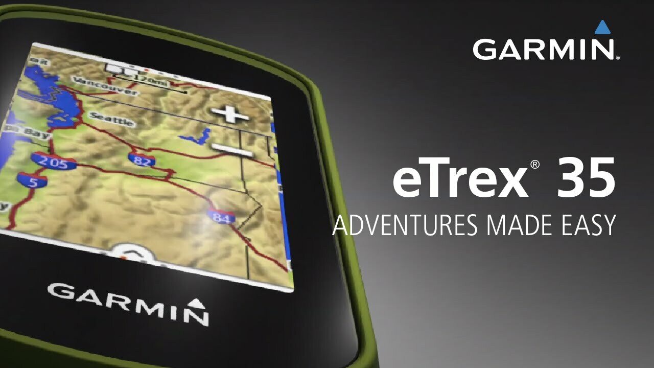
eTrex Touch 35 is the new family navigator for outdoor activities and alpine adventures, ideal for everyone that likes to dip their toes into the great outdoors - from casual cyclists and hikers to geocaching newbies and hillwalkers.
eTrex has been the world’s most popular and successful recreational GPS series for the past 15 years. eTrex Touch 35 is its newest member, that is now easier and more convenient to use than ever. With additional altimeter, it also supports alpine activities like mountaineering and mountain biking. It comes with preinstalled TopoActive Europe maps and optimised Activity Profiles for various recreational activities, not forgetting 250,000 geocaches for endless fun outdoors. With smart notifications straight to your device from your smartphone1, you can stay connected when you’re on the go. To make it even easier to get going, a cycling mount is included in the box. Get out there and have fun with the family. eTrex will guide you every step of the way.
Garmin family navigator that’s easy and fun to use, with touchscreen, altimeter and preloaded TopoActive Europe maps
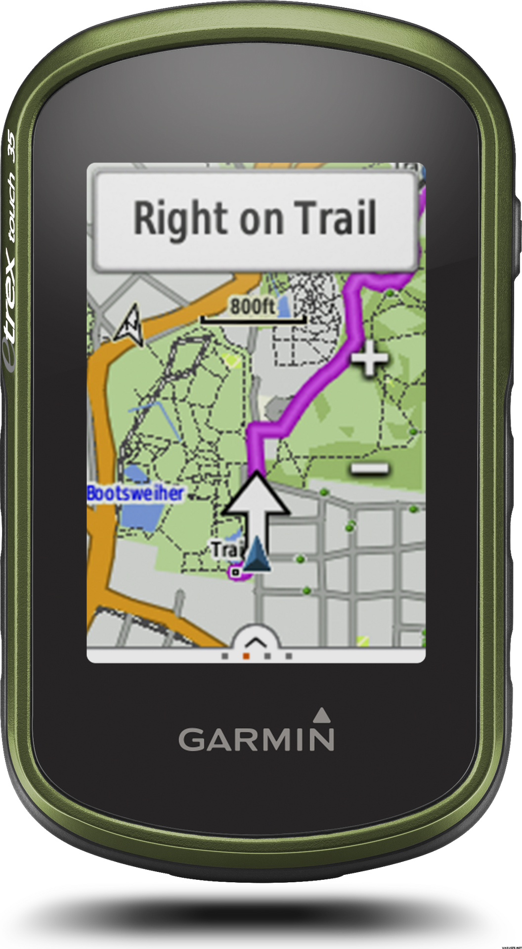
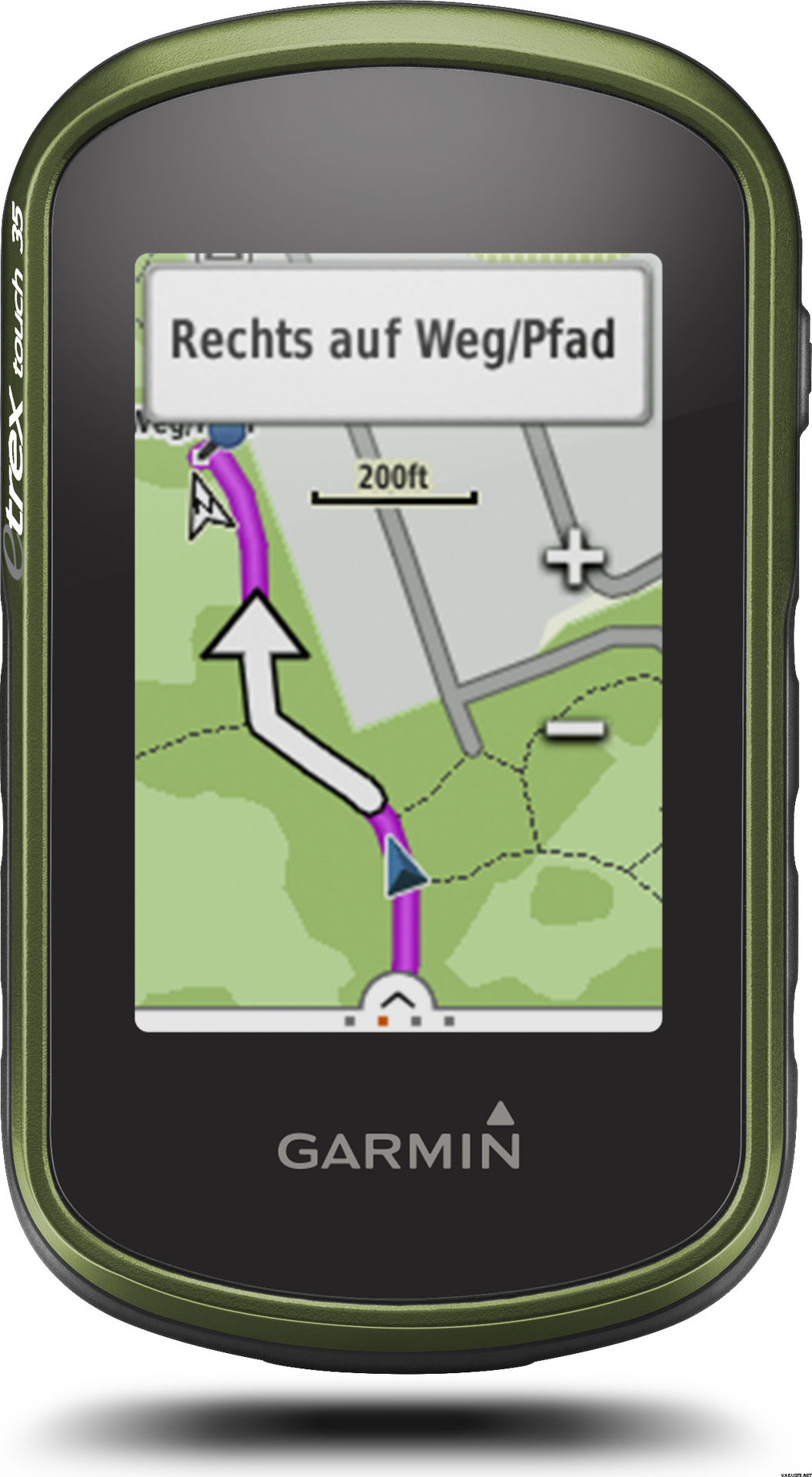
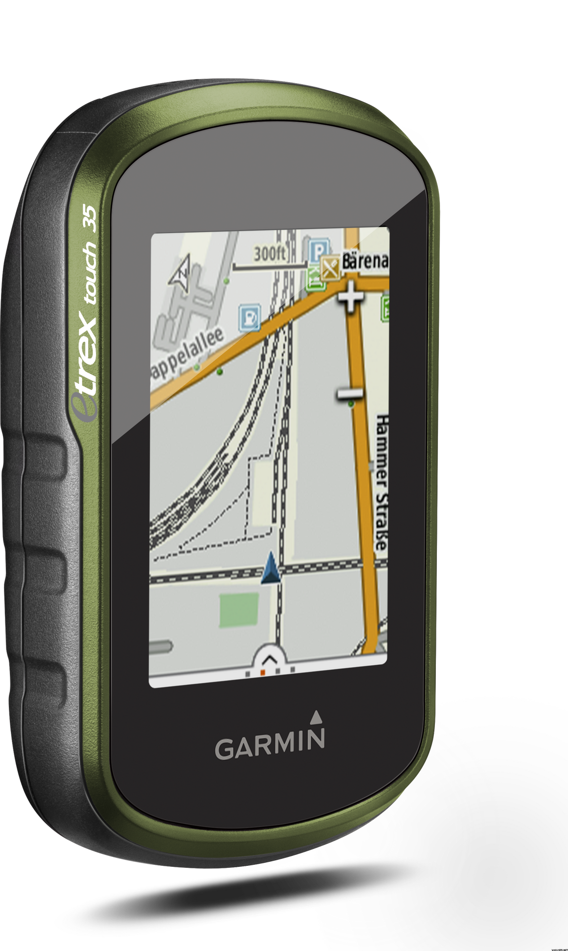
Find your way the easy way
eTrex Touch works like an in-car sat nav, but with maps and features specifically designed for navigation during recreational activities like cycling and hiking. Whether you have a specific destination in mind, or you just want to record your activities to share later on, eTrex Touch gives you the freedom to explore with confidence. You can even find and download activities others have completed on Garmin Connect and Garmin Adventures, or share your own with the community.
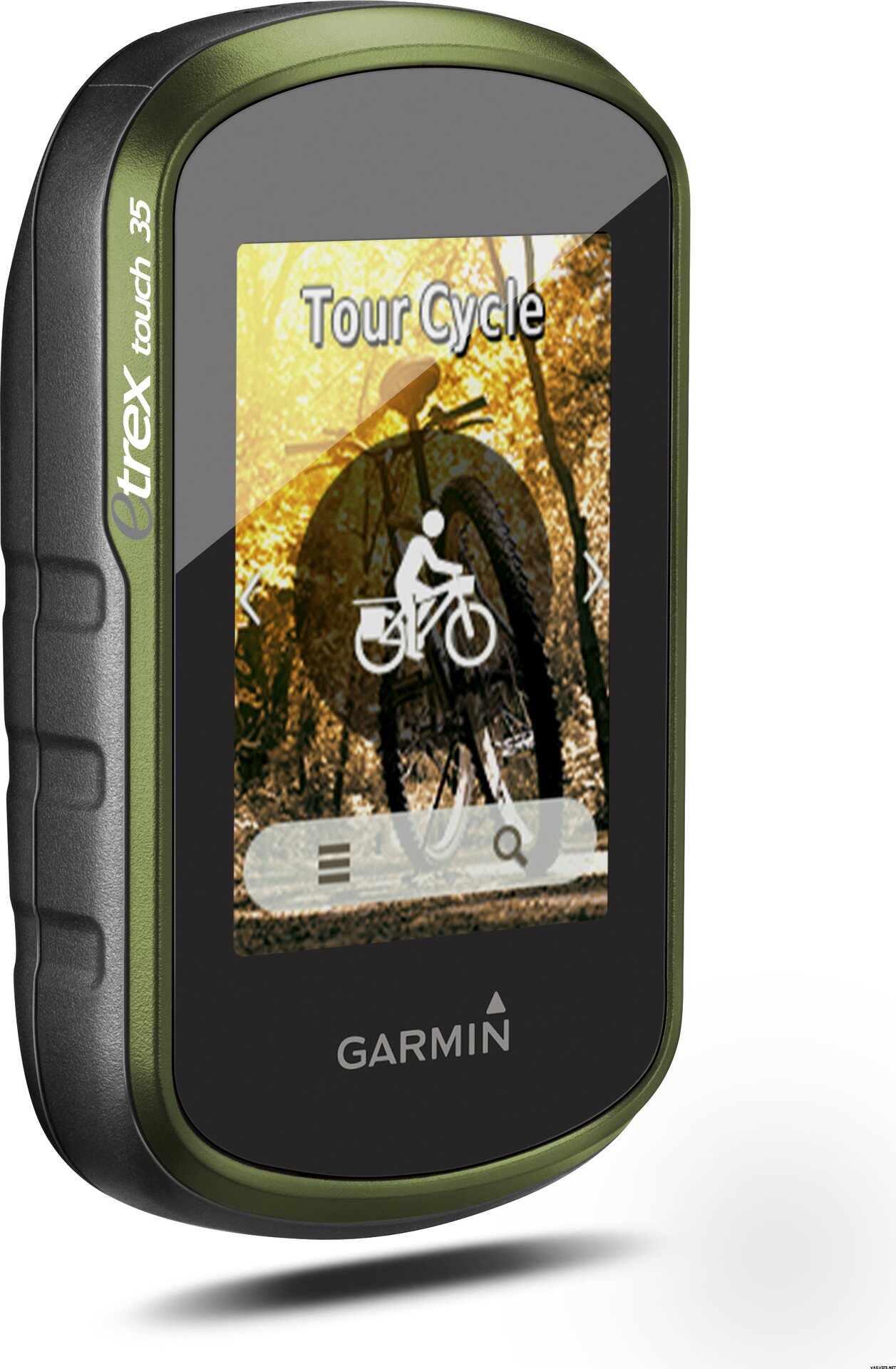
With an easy to use touchscreen, the kids will be able to have a go too. Just touch and go, as the moment takes you! The Activity Profiles give you immediate access to customised profiles like hiking, cycling and geocaching, so you’re all set up for your chosen activity, with everything you need at your fingertips. You can focus on enjoying the great outdoors, and having a great time with your family – knowing you’re in safe hands.
All ready and set to ride
eTrex Touch holds no one back, it’s everything you need to get out there and experience the outdoors at every opportunity. Not only is it designed to enhance whatever activity you fancy that day but it comes fully prepared for you to take it straight out the box and get going.
With a cycling mount included, the eTrex Touch is particularly appealing to recreational cyclists, who can easily fix the device to their handlebars.
The device comes preloaded with Garmin TopoActive Europe maps for 46 countries - just switch the device on, connect to GPS and start navigation. And the maps can be updated at no additional cost. With a large 8 GB internal memory and a microSD slot, there’s plenty of room for additional mapping, whether you’d like to enhance it with advanced topo maps or marine maps.
Dive into geocaching
Experience the great outdoor GPS treasure hunt called geocaching. With the eTrex Touch, geocaching is convenient for everyone, with paperless geocache directions, ratings and recent logs saved directly on the device - no need to print anything.
eTrex Touch 35 comes with an electronic compass that shows you the direction to your destination even while you’re stood still - which helps a lot during short breaks on geocaching adventures.
For beginners, eTrex Touch holds 250,000 great geocaches suitable for those new to geocaching – to help you get used to the whole concept. All geocaches are from geocaching.com, the world’s largest geocaching platform.
Adventures unearthed and shared
Don’t have a specific destination or route in mind? Search for recommended adventures on Garmin Connect or Garmin Adventures, and see routes and geocaches that others have completed. Then download them to eTrex Touch ready for your next adventure. Or create and customise a completely new route to download to your device.
Want to save and re-live a recent adventure? eTrex Touch records where you’ve been so you can upload your routes to Garmin Connect or Garmin Adventures and relive them whenever you want. Garmin Connect and Garmin Adventures are free and allow you to share your recreational adventures with friends and family.
Rock solid eTrex quality
eTrex Touch is the latest product from the famous eTrex GPS handheld series. These products have been successfully deployed all over the earth, from the freezing poles to the heat of African deserts and the humid South American jungles. eTrex has mastered all terrains and the eTrex Touch offers that same toughness and endurance.
eTrex Touch supports GPS and GLONASS, giving you the power of two satellite systems, for faster fix and better accuracy in challenging environments. Let eTrex do all the hard work for you – just check your actual position and follow the guidance. eTrex 35 also adds a barometric altimeter to the mix, for safer navigation in alpine environments and accurate elevation data.
The device is fully ruggedised, IPX7 water-rated and has a scratch-resistant screen. The long 16 hour battery life and field-replaceable standard AA batteries guarantee flexibility when you’re on the go.
eTrex Touch also provides all of the classic eTrex features like hunting and fishing information, sport watch, sun and moon calendar, sunrise and sunset data and much more.
Compact and versatile companion
The handy device fits easily into a pocket or on a handlebar. It’s also designed to be a size that allows kids to easily handle it too. Using the spine mount mounting system, eTrex Touch can be mounted pretty much anywhere with specialised mounts for boats, cars, backpacks etc.
Stay connected
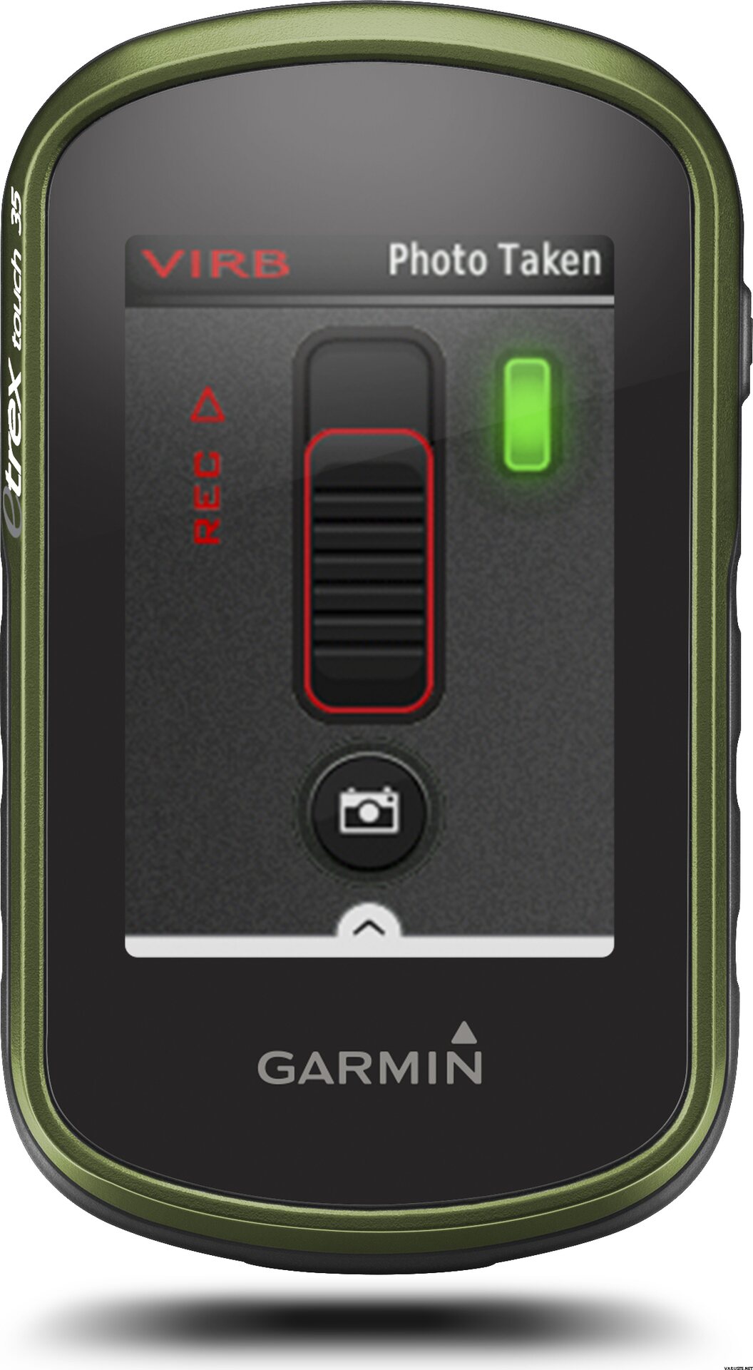
eTrex Touch 35 lets you share your waypoints, tracks, routes and geocaches wirelessly, through unit-to-unit sharing with compatible Garmin devices. With the smart notification feature, you’ll never miss a text, email or notification from your compatible smartphone*, unless you want to. You can also use your eTrex Touch 35 as a remote control for our VIRB® XE, VIRB X and VIRB Elite action cameras.
eTrex Touch 35 also supports Live Track which allows your friends and family to follow your activities in real time. Invite followers, via email or social media, to track your activity and location on Garmin Connect.
Physical & Performance
Physical dimensions5.8 x 10.2 x 3.3 cm
Display size, WxH3.6 x 5.5 cm
Display resolution, WxH160 x 240 pixels
Display type2.6" 65K colour TFT
Touchscreen
Weight159 g with batteries
Battery2 AA batteries (not included); NiMH or Lithium recommended
Battery lifeUp to 16 hours
Water ratingIPX7
High-sensitivity receiver
InterfaceUSB
Camera
No
Barometric altimeter
Electronic compass
Unit-to-unit transfer (shares data wirelessly with similar units)
Maps & Memory
Basemap
Preloaded maps
No
Ability to add maps
Built-in memory8 GB
Accepts data cardsmicroSD™ card (not included)
Custom POIs (ability to add additional points of interest)
Waypoints/favorites/locations4000
Routes200
Track log10,000 points, 200 saved tracks
Outdoor Features
Automatic routing (turn by turn routing on roads)Yes (with optional mapping for detailed roads)
Geocaching-friendlyYes (Paperless)
Custom maps compatible
Sun and moon information
Tide tablesYes (with optional Bluechart)
Area calculation
Picture viewer
Garmin Connect™
Garmin Connect™ compatible (online community where you analyze, categorize and share data)
Additional
Additional
Smart Notifications: Yes
Live Tracking: Yes (with Garmin Connect™ Mobile)
 Taiwan
 — Näita originaali
 — Näita originaali
Hea, et rakendus on mälukaardil valmis. Vajadusel saab selle alla laadida ka Riigi Maamõõtmise kodulehelt. Garmin eTrexil on mugav suurus. Suurus loeb, alati ei taha suurt suurust kaasa võtta. Seadmega kaasas ei olnud soomekeelset kasutusjuhendit. Netist leiab ja sealt saab ka välja printida.Soomest ostetud seadmelt eeldaks ka juhendit, soovitavalt värvilist väljatrükki.. Seadet on lihtne kasutada. Laetavad akud kestavad kõige kauem. Tasub hankida, tarne ei kuulu, mis on juba tellimisel teada.| Üldhinnang |
— Näita originaaliHea ja täpne seade. Üsna keerulised menüüd, nii et ma pole kõiki funktsioone veel õppinud.| Üldhinnang |
— Näita originaaliSeadme ostsin eelkõige geopeituse jaoks ja teiseks rattasõiduks. Otsisin väikest puutetundliku ekraaniga seadet, millel oleks hea aku vastupidavus ja see valiti. Menüüde navigeerimisloogikaga harjumine võttis aega, kuid vajalikud funktsioonid ja seadistused hakkasid sealt täitsa kenasti leiduma. Tegu on väikese seadmega, kuid ekraanilt ja kaardilt saab sellest piisavalt hästi aru. Mul on probleeme vahemälude seadmesse laadimisega (ükshaaval arvuti brauserist seadmesse ülekandmine). Tõenäoliselt oleks lihtsam kasutada Geocachingu taskupäringut, kui teil oleks premium-liikmesus. Seejärel muutub sagedamini Garmini vahemälu koordinaatide sisestamine ja telefoni vahemälu kirjelduste sirvimine. Jalgrattasõidus pidi Garmin telefoni asendama navigeerimisel ja varutoiteallikate kandmisel. Kaasas olev rattahoidja on lihtsalt korralik, kuigi seal on kaablikinnitus. Navigeerimisfunktsioonid ei ole parimad võimalikud, vähemalt linnajooksude puhul. Enne Garmini hankimist meeldis mulle planeerida Google Mapsiga rattamatk uutesse piirkondadesse ja see oma telefoni kanda. Marsruudi planeerimine Garmini Base Camp programmis (arvutis) või otse seadmesse sisestatav marsruudi planeerimine ei ole vähemalt esmapilgul kuigi lihtne. Võib-olla seetõttu jäin rattajooksude abimeheks rohkem telefoninavigatsiooni juurde, kuigi väikese pingutuse ja õppimisega saaks isegi Garmini talutavale tasemele viia.| Üldhinnang |
— Näita originaaliOn hästi toiminud. Kui aga ükskord näitas see vahemaad, mille olin läbinud lihtsalt kogemata, kas siis suure pakase tõttu, siis akudel oli sinna jõudes jõudu. Mobiilirakenduses Garmin Contact võiks olla programm, mis salvestab nt igakuised matkad| Üldhinnang |
— Näita originaaliOK põhi Gepsi. Ekraan pole mobiiltelefoniga võrreldes kuigi kummaline, kuid toob pikematel reisidel navigeerimiseks kindlust ja turvalisust.| Üldhinnang |
— Näita originaaliKäepärase suurusega seade ja lihtne kasutada pärast väikest treeningut. Kinnitus sambale on kena lisand ja aitab jalgrattaga sõites marsruuti leida.
Peamiselt mõeldud kasutamiseks Geopeituse jaoks.Tarne oli kiire ja seltskond juba tuttav, kõik toimib hästi.| Üldhinnang |
— Näita originaaliKaval näpunäide. Sain selle algselt geopeituse jaoks, aga ilmselt on see info andmiseks ja kaardi näitamiseks paigutatud ratta lenkstangi ... reitesse tuleb ilmselt rohkem püssirohtu:) Geopeituses tundus ekraan kuidagi liiga väike, aga ehk harjud sellega ära. Infot näidatakse rattaga sõites üllatavalt hästi ja kaart on hästi loetav.
See võtab palju akusid, seega sain kohe laetavad akud ja laadija. Hea näpunäide!| Üldhinnang |
— Näita originaaliVäga mitmekülgne spordinavigaator. Kasutan seda peamiselt mägirattasõiduks, kuid sobib ka matkamiseks ja suusatamiseks.| Üldhinnang |
— Näita originaaliHea, kuid nende rikkalike profiilide ja menüüde jaoks on vaja natuke aega treenida.