 reviews
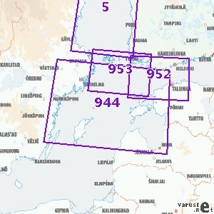
Yleismerikartta 944, 1:500 000, Pohjois-Itämeri, 2007
Availability
This product could not be added to the shopping cart, because it is not for sale at the moment or for some other reason.
Product description
Weight
0,16 kg
Isbn
9789514910197
CommentsAdd a comment
This product could not be added to the shopping cart, because it is not for sale at the moment or for some other reason.
Product description
Merenkulkulaitoksen merialueiden yleiskartat sekä Saimaan vesistön yleiskartta ovat tarkoitettu avomeripurjehdukseen ja reittisuunnitteluun. Karttojen mittakaava vaihtelee alueellisesti välillä 1:100 000 - 1: 500 000. Karttojen ulkoasu on suora.
The approximate size of the packed product or the sales package is 35 x 818 x 35 mm.
Weight
0,16 kg
Isbn
9789514910197
CommentsAdd a comment