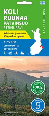
Koli Ruunaa Patvinsuo Petkeljärvi 1:25 000, waterproof map 2020
This product is not for sale at the moment.
Detailed availability
Reviews
| Overall rating | (9 reviews) |
Product description
Ulkoilukartta Koli Ruunaa Patvinsuo Petkeljärvi 1:25 000 kattaa Pohjois-Karjalan suosituimmat retkeilyalueet. Kaksipuolisella kartta-arkilla on kolmen kansallispuiston (Koli, Patvinsuo ja Petkeljärvi) sekä Ruunaan retkeilyalueen kartat, kaikki samassa mittakaavassa 1:25 000 (1 cm kartalla on 250 m maastossa). Kartta on painettu vedenkestävälle materiaalille. Kestävät kotimaiset ulkoilukarttamme tunnistat kannen keltaisesta merkinnästä, ja ne on pakattu pahvikoteloon.
Koli on kävijämäärältään yksi maamme suosituimmista kansallispuistoista. Kolille houkuttelee paitsi upea kansallismaisema, myös hyvät lähiretkeilymahdollisuudet ja Herajärven kierros -vaellusreitti.
Patvinsuo on erämainen kansallispuisto, jossa on vanhoja metsiä, avaria soita ja hiekkarantaisia järviä. Alueen polkuverkosto soveltuu hyvin muutaman päivän retkiin, ja retkeä voi helposti jatkaa etelään tai pohjoiseen Karjalan kierroksen reittejä pitkin.
Petkeljärvi sijaitsee aivan itärajan tuntumassa Ilomantsissa. Kansallispuisto tunnetaan komeista harjuista, kirkasvetisistä järvistä ja sodanaikaisista varustuksista. Puiston alue sopii päiväretkeilyyn ja pohjoiseen suuntautuva Taitajan taival -reitti pidempiin retkiin.
Ruunaan retkeilyalue ja luonnonsuojelualue Lieksassa tunnetaan vapaana virtaavasta Lieksanjoesta, jonka kosket tarjoavat elämyksiä kalastajille, melojille ja matkailijoille. Myös Ruunaalla on useiden kymmenien kilometrien retkeilyreitistö ja latuverkosto.
Kartan materiaali on täysin vedenpitävää ja kestää lähes rajattomasti taittamista, eikä se repeä helposti normaalissa karttakäytössä. Ominaisuudet säilyvät myös pakkasessa ja helteessä. Kartta on sormituntumaltaan miellyttävä ja paperille painettua kevyempi.
Maastotietojen lisäksi karttaan on merkitty reitit ja muut retkeilypalvelut sekä ruokailu- ja majoituspaikat. Kartalle on lisätty sen alueelta kymmenen nähtävyyttä tai kokemusta, joista on kerrottu muutamalla lauseella kartan reunuksessa suomeksi ja englanniksi. Kartan reunuksessa on myös tiedot erannosta.
Kartta on saatavilla myös mobiililaitteilla käytettävänä digitaalisena versiona. Lue tästä lisää!
Mittakaava
1:25 000
Kustantaja
Karttakeskus
Koko
70 × 100 cm
Ulkoasu/sidosasu
taitettu, vedenkestävä
Kieli
fin, swe, eng, ger, rus
Sarja
Ulkoilukartat
Painos
1.
Kirjastoluokka
42.02
Painovuosi
2020
Waterproof
Yes
Weight
0,1 kg
Isbn
978-952-266-515-7
Comments
| Overall rating | ☆☆☆☆☆ |
 — Show original
 reviews
