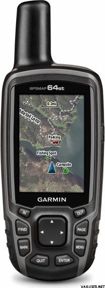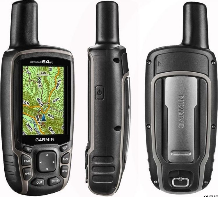
Garmin GPSMAP 64st
Αυτό το προϊόν δεν είναι προς πώληση αυτή τη στιγμή.
Λεπτομερής διαθεσιμότητα
Αξιολογήσεις
| Συνολική βαθμολογία | (20 αξιολογήσεις) |
Περιγραφή προϊόντος
Rugged, Full-featured Handheld with GPS, GLONASS and Wireless Connectivity
2.6" sunlight-readable color screen
High-sensitivity GPS and GLONASS receiver with quad helix antenna
1-year BirdsEye Satellite Imagery subscription
3-axis compass with barometric altimeter
Wireless connectivity via Bluetooth® technology¹ or ANT+™
GPSMAP 64s
GPSMAP 64s features a 2.6” sunlight-readable color screen and a high-sensitivity GPS and GLONASS receiver with a quad helix antenna for superior reception. GPSMAP 64s includes a 3-axis electronic compass with barometric altimeter, wireless connectivity and a 1-year BirdsEye Satellite Imagery subscription.
Get Your Bearings
GPSMAP 64s has a built-in 3-axis tilt-compensated electronic compass, which shows your heading even when you’re standing still, without holding it level. Its barometric altimeter tracks changes in pressure to pinpoint your precise altitude, and you can even use it to plot barometric pressure over time, which can help you keep an eye on changing weather conditions.
Share Wirelessly
Share your waypoints, tracks, routes and geocaches wirelessly with other compatible devices. Your friends can enjoy your favorite hike or cache without waiting for you to plug in to your computer — simply press “send” to transfer your information to another Garmin handheld.
GPSMAP 64st also connects to compatible Garmin devices, including VIRB™ and accessory sensors, including tempe™, foot pod and heart rate monitor.
Stay Connected
With Smart Notification you can wirelessly receive email, texts and alerts from your compatible iPhone® 4s or later. Stay connected without having to dig into your backpack for your smartphone.
Explore the Terrain
GPSMAP 64s comes with a built-in worldwide basemap with shaded relief plus a 1-year BirdsEye Satellite Imagery subscription, so you can navigate anywhere with ease. With photo navigation, you can download geotagged pictures from the Internet and navigate to them.
Keep Your Fix
With its quad helix antenna and high-sensitivity, GPS and GLONASS, receiver, GPSMAP 64s locates your position quickly and precisely and maintains its location even in heavy cover and deep canyons. The advantage is clear — whether you’re in deep woods or just near tall buildings and trees, you can count on GPSMAP 64s to help you find your way when you need it the most.
Add Maps
GPSMAP 64s comes with a built-in worldwide basemap with shaded relief and a 1-year subscription of BirdsEye Satellite Imagery for a photo-realistic view. Adding more maps is easy with our array of detailed topographic, marine and road maps. With 4 GB of onboard memory and microSD™ card slot, you can conveniently download TOPO 24K and 100K maps and hit the trail, plug in BlueChart® g2 preloaded cards for a great day on the water or City Navigator NT® map data for turn-by-turn routing on roads (see maps tab for compatibility). In addition, the 64s is compatible with Garmin Custom Maps, a map format that allows you to transform paper and electronic maps easily into downloadable maps for your device, for free.
Find Fun
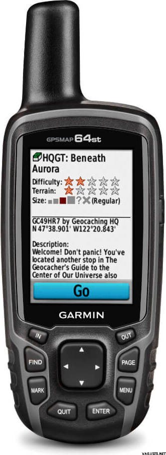
GPSMAP 64s supports paperless geocaching with 250,000 preloaded caches with hints and descriptions from Geocaching.com, and has a 16-hour battery life. By going paperless, you're not only helping the environment, but also improving efficiency. GPSMAP 64s stores and displays key information, including location, terrain, difficulty, hints and descriptions, which means there’s no more manually entering coordinates and paper printouts! Slim and lightweight, 64s is the perfect companion for all your outdoor pursuits.
Plan Your Next Trip
Take charge of your next adventure with BaseCamp™, software that lets you view and organize maps, waypoints, routes and tracks. This free trip-planning software even allows you to create Garmin Adventures that you can share with friends, family or fellow explorers. BaseCamp displays topographic map data in 2-D or 3-D on your computer screen, including contour lines and elevation profiles. It also can transfer an unlimited amount of satellite images to your device when paired with a BirdsEye Satellite Imagery subscription.
Αυτό το προϊόν μπορεί να παραδοθεί μόνο με τις παρακάτω μεθόδους:
- Παραλαβή από το κατάστημα
- Ειδική παλέτα
- Ευρωπαλέτα, κατά τις ώρες εργασίας
- Ευρωπαλέτα, στον συμφωνημένο χρόνο
- Καρότσι rolltainer, κατά τις ώρες εργασίας
- Καρότσι rolltainer, στον συμφωνημένο χρόνο
- Παράδοση στο κατώφλι όπως συμφωνήθηκε (Matkahuolto Kotijakelu)
- Παράδοση στο κατώφλι όπως συμφωνήθηκε (Posti Home Parcel)
- Παράδοση στο κατώφλι (DB Schenker)
- Παράδοση στο κατώφλι (Matkahuolto Jakopaketti)
- Παράδοση στο κατώφλι (Posti)
- Παράδοση στο κατώφλι (Posti πρωί)
- Παραλαβή από ντουλάπι δεμάτων (Posti)
- Παραλαβή από ντουλάπι δεμάτων (PostNord)
- Παραλαβή από το σημείο παράδοσης (Matkahuolto)
- Παραλαβή από το σημείο παράδοσης Posti
- Παραλαβή από το σημείο παράδοσης (PostNord)
- Παραλαβή από το R-kioski ή το K-Market Parcel Point (DB Schenker)
- Ταχεία παράδοση στη διεύθυνση του παραλήπτη (DHL Express Worldwide)
- Φάκελος με παρακολούθηση
- Posti freight to doorstep
Ανάλυση οθόνης
160 x 240
Βαρομετρικό υψόμετρο
Ναι
Battery life max (h)
16
Satellite communication
Όχι
Screen size (inches)
2,6
Suitable for geocaching
Ναι
Βάρος
0,45 kg
(με το πακέτο πωλήσεων 0,8 kg)
Εγγύηση
24 μήνες
Χώρα προέλευσης
Σχόλια
 — Εμφάνιση πρωτότυπου
Είμαι πολύ ικανοποιημένος με το Garmin, το έχω ήδη χρησιμοποιήσει πολύ και γνώρισα πώς να το χρησιμοποιώ. Σας το παρήγγειλα λίγες μέρες αργότερα
μπαταρία και είναι πραγματικά λυπηρό όταν διαρκεί μόνο τρεις ώρες και ο χρόνος φόρτισης διαρκεί έως και επτά ώρες. Έχει την ημερομηνία
18/10 που αν είναι η τελευταία μέρα χρήσης, δεν εκπλήσσομαι καθόλου.
ΤΗΛΕΟΡΑΣΗ. Jukka Hakala Suomussalmi| Συνολική βαθμολογία |
Το χρησιμοποιώ για απόκρυψη, και έχω πάει σε μερικές αποθήκες και ήταν ακριβές. Η χρήση απαιτεί μάθηση και ακόμα δεν τα ξέρω όλα. Έτσι τον χειμώνα καλό είναι να χρησιμοποιείτε τα κλειδιά ακόμα και με γάντια. Η οθόνη είναι μικρή, αλλά κάνει τη δουλειά. Έκανα την αντιστοίχιση με το κινητό τηλέφωνο, αλλά δεν κατάφερα να μεταφέρω με επιτυχία τα δεδομένα!Αποκτήθηκε ως συνοδός του παλιού gpasmap60 επειδή ολόκληρος ο χάρτης εδάφους της Φινλανδίας δεν μπορούσε να εγκατασταθεί στο παλιό μοντέλο. Από πολλές απόψεις, η συσκευή περιέχει ακριβώς τις ίδιες λειτουργίες, αλλά στο παλιό μοντέλο 60, κατά τη γνώμη μου, οι λειτουργίες είναι πιο εύκολο να βρεθούν από τη σκοπιά του χρήστη, δηλαδή η διεπαφή χρήστη πριν δεν ήταν όμορφη, αλλά απλώς μαγική . Καταρχήν, η ακρίβεια έχει βελτιωθεί (;) λόγω και του glonass, αλλά όταν εκεί, ο μετρητής μερικές φορές συσσωρεύει χιλιόμετρα, ο λόγος δεν έχει διευκρινιστεί ακόμη οριστικά. Ας ελπίσουμε ότι θα υπάρξει ενημέρωση λογισμικού για αυτό.Μάρκα
Δείτε επίσης


 αξιολογήσεις


