

Garmin
196 продукти

Popular Handheld GPS with Enhanced Display and Preloaded Mapping
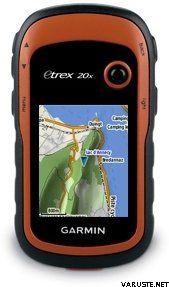
2.2 inch crystal clear colour display
Preloaded Western Europe Garmin ActiveMap with shaded relief
High-sensitivity, GPS receiver with HotFix® and GLONASS support
4GB internal memory. Expand further with a microSD™ card (not included).
Worldwide basemap with shaded relief
eTrex 20x is our upgraded version of the popular eTrex 20, with enhanced screen resolution and extended internal memory to hold more maps. The preloaded Garmin ActiveMap supports and enhances a range of outdoor activities, such as hiking, geocaching, cycling, mountaineering and fishing. eTrex 20x has enhanced features compared to eTrex 20, while maintaining its ease-of-use, affordability and legendary durability.
See the Way
eTrex 20x has an enhanced 2.2 inch, 65K colour, sunlight-readable display. Durable and water-resistant, eTrex 20x is built to withstand the elements. It has an upgraded interface yet retains its toughness to withstand dust, dirt, humidity or water.
Go Anywhere
Fit your eTrex 20x just about anywhere, using an array of compatible mounts. Use the auto mount capability and City Navigator NT® maps for turn-by-turn driving directions, or the rugged mount for your bike or quad. You can even mount to a boat for fishing or sailing trips.
Go Global
The eTrex series can track both GPS and GLONASS satellites simultaneously – it has the ability to lock on to 24 more satellites than using just GPS. What’s more, the time it takes to “lock on” to a position is (on average) 20% faster than using GPS alone. With its high-sensitivity EGNOS-enabled GPS receiver and HotFix satellite prediction, eTrex locates your position quickly and precisely and maintains its GPS location even in heavy cover and deep valleys.
Preloaded Garmin ActiveMap
eTrex 20x comes preloaded with the new Garmin ActiveMap of Western Europe, a perfect starting point for your first recreational activity with GPS. The map provides relevant useful information for activities like hiking and cycling, it's routable and shows elevation changes*. Garmin ActiveMap Western Europe covers the following 23 countries: Andorra, Austria, Belgium, Denmark, Finland, France, Germany, Iceland, Ireland, Italy, Liechtenstein, Luxembourg, Malta, Monaco, Netherlands, Norway, Portugal, San Marino, Spain, Sweden, Switzerland, United Kingdom, Vatican City.
Use the microSD™ card slot to load additional advanced maps – like Topo maps, BlueChart® g2 marine maps or City Navigator® NT maps. eTrex 20x also supports BirdsEye Satellite Imagery (subscription required) to download and integrate with your maps.
* Garmin ActiveMap is based on OSM mapping data, map quality depends heavily on local mapping coverage, Garmin cannot guarantee the quality and completeness of mapping data
Find Fun
eTrex 20x supports paperless geocaching GPX files for endless geocaching adventures. Just visit Geocaching.com to download geocaches straight to your device, then start hunting for caches! eTrex 20x stores all the key information, including location, terrain, difficulty, hints and descriptions. By going paperless, you're not only helping the environment but also avoiding the bother of manually entering co-ordinates.
Plan Your Next Trip
Take control of your next adventure with BaseCamp™. The free, trip-planning software allows you to view and organise maps, routes and more, and even create Garmin Adventures to share with friends, family or fellow explorers. BaseCamp displays topographic map data in 2D or 3D on your computer screen, as well as a vast array of satellite images when paired with a BirdsEye Satellite Imagery subscription.
*Garmin ActiveMap is based on OSM mapping data, map quality depends heavily on local mapping coverage, Garmin cannot guarantee the quality and completeness of mapping data
Physical & Performance
Physical dimensions5.4 x 10.3 x 3.3 cm
Display size, WxH3.5 x 4.4 cm; 5.6 cm diag
Display resolution, WxH240 x 320 pixels
Display type2.2" transflective, 65K colour TFT
Weight141.7 g with batteries
Battery2 AA batteries (not included); NiMH or Lithium recommended
Battery lifeUp to 25 hours
Water ratingIPX7
High-sensitivity receiver
InterfaceUSB
Camera
No
Maps & Memory
Basemap
Preloaded maps
Yes - Garmin ActiveMap of Western or Eastern Europe
Ability to add maps
Built-in memory3.7 GB including preloaded maps
Accepts data cardsmicroSD™ card (not included)
Custom POIs (ability to add additional points of interest)
Waypoints/favorites/locations2000
Routes200
Track log10,000 points, 200 saved tracks
Outdoor Features
Automatic routing (turn by turn routing on roads)Yes (with optional mapping for detailed roads)
Geocaching-friendlyYes (Paperless)
Custom maps compatible
Sun and moon information
Tide tablesYes (with optional Bluechart)
Area calculation
Picture viewer
Garmin Connect®
Garmin Connect™ compatible (online community where you analyze, categorize and share data)
 Китай
Китай — Покажи оригинала